M5.2 earthquake 22 km SSW of Adak, Alaska
A magnitude 5.2 earthquake struck 22 km SSW of Adak, Alaska on Thu, Feb 15, 2018, 2:00 PM HAST (00:00 UTC), 51 km (32 mi) below the surface.
Map
Where this earthquake was located, with the others nearby. Select one for its page.
The earthquake
- Magnitude
- 5.2 (Mww, W-phase moment), moderate
- Magnitude from
- USGS National Earthquake Information Center
- Local time
- UTC
- 2018-02-16 00:00:15 UTC
- Depth
- 50.8 km (31.6 mi), shallow
- Epicenter
- 51.690° N, 176.778° W
- Region
- Alaska
- Felt reports
- 1
- Strongest shaking
- IV, light shaking
- Tsunami flag
- Yes: a large quake in an oceanic region
- Status
- Reviewed by a seismologist
Magnitude estimates
Different scales measure different things and differ by a few tenths. The USGS marks one as preferred, and it is the one this page uses.
| Mag. | Scale | Computed by | Notes |
|---|---|---|---|
| 5.2 | Mww, W-phase moment | USGS National Earthquake Information Center | Preferred · Reviewed · ±0.05 · 39 stations |
| 5.22 | Mw, moment | ISC-GEM global catalog | Final · ±0.1 |
| 5.2 | Mw, moment | Alaska Earthquake Center | Preliminary |
| 5.0 | ML, local (Richter) | NOAA National Tsunami Warning Center | Reviewed · 5 stations |
What happened
The USGS’s account of the effects of this earthquake.
Felt strongly on Adak.
From the USGS event page for us2000d2yz. U.S. Geological Survey text and figures are in the public domain.
Tsunami
The USGS flags a quake this large in an oceanic region. The flag does not mean a tsunami happened; the tsunami warning centers decide that, and their messages are below when they issued any.
Current tsunami warnings: tsunami.gov. Warnings in force in the US also appear on our alerts pages.
Shaking
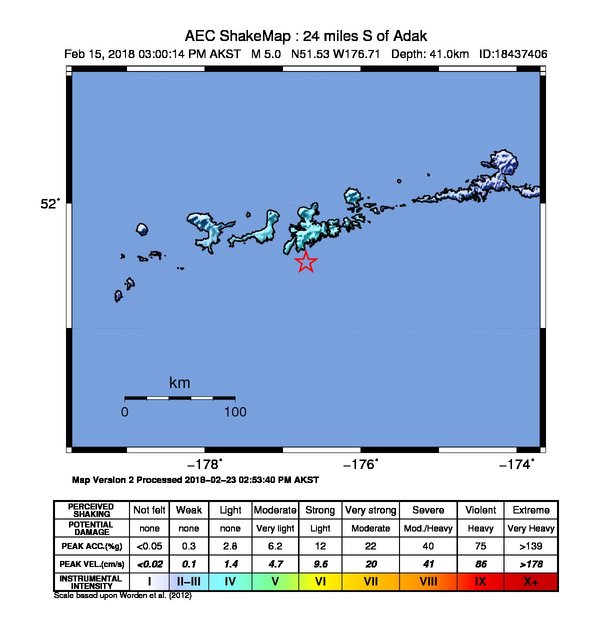
The USGS ShakeMap: shaking estimated from seismic stations and the quake’s size, on the Modified Mercalli intensity scale.
- Strongest estimated
- IV, light shaking
- Map
- Automatic
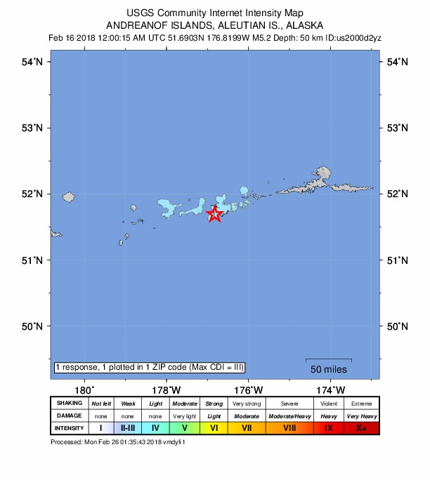
Did you feel it?
1 person reported to the USGS what they felt; the strongest reported shaking was III, weak shaking.
Fault motion and ground failure
How the rock slipped, from the moment tensor, and the USGS estimate of landslides and liquefaction.
- Faulting
- Oblique reverse
- Moment magnitude
- 5.2 Mww
- Nodal plane 1
- Strike 278°, dip 39°, rake 120°
- Nodal plane 2
- Strike 61°, dip 57°, rake 68°
How well it is located
Reviewed by a seismologist.
- Location uncertainty
- About 6.1 km horizontally, 3.9 km in depth
- Magnitude uncertainty
- ±0.05
- Depth from
- From location
- Station coverage gap
- 84°
- Stations used
- 217
Nearby
Within 100 km, magnitude 2.2 and up: 59 in the 60 days after this one and 46 in the 30 days before it.
After
- 2.437 km ESE of Adak, Alaska · 3150 days ago · 61 km deep · 43 km away
- 2.8118 km SW of Adak, Alaska · 3150 days ago · 35 km deep · 98 km away
- 2.451 km SE of Adak, Alaska · 3149 days ago · 35 km deep · 45 km away
- 2.462 km ESE of Adak, Alaska · 3145 days ago · 50 km deep · 69 km away
- 2.4110 km SW of Adak, Alaska · 3145 days ago · 52 km deep · 91 km away
- 2.343 km S of Adak, Alaska · 3142 days ago · 40 km deep · 24 km away
- 3.7111 km SW of Adak, Alaska · 3142 days ago · 40 km deep · 92 km away
- 2.674 km WSW of Adak, Alaska · 3140 days ago · 45 km deep · 58 km away
- 2.7102 km SW of Adak, Alaska · 3140 days ago · 26 km deep · 82 km away
- 2.894 km W of Adak, Alaska · 3140 days ago · 112 km deep · 88 km away
- 2.239 km WSW of Adak, Alaska · 3140 days ago · 79 km deep · 31 km away
- 2.261 km W of Adak, Alaska · 3140 days ago · 84 km deep · 59 km away
- 2.250 km SSE of Adak, Alaska · 3139 days ago · 15 km deep · 36 km away
- 3.443 km E of Adak, Alaska · 3137 days ago · 135 km deep · 57 km away
- 2.240 km SE of Adak, Alaska · 3134 days ago · 52 km deep · 42 km away
- 2.255 km S of Adak, Alaska · 3134 days ago · 24 km deep · 37 km away
- 2.341 km ESE of Adak, Alaska · 3133 days ago · 51 km deep · 45 km away
- 2.533 km NNW of Adak, Alaska · 3133 days ago · 164 km deep · 51 km away
- 2.8Andreanof Islands, Aleutian Islands, Alaska · 3131 days ago · 34 km deep · 33 km away
- 2.670 km E of Adak, Alaska · 3130 days ago · 75 km deep · 82 km away
- 4.6111 km SW of Adak, Alaska · 3130 days ago · 48 km deep · 90 km away
- 2.656 km SE of Adak, Alaska · 3129 days ago · 35 km deep · 50 km away
- 2.8108 km SW of Adak, Alaska · 3128 days ago · 53 km deep · 90 km away
- 2.536 km S of Adak, Alaska · 3128 days ago · 56 km deep · 22 km away
- 3.938 km SSW of Adak, Alaska · 3125 days ago · 34 km deep · 16 km away
- 2.243 km SSE of Adak, Alaska · 3125 days ago · 26 km deep · 35 km away
- 2.218 km NNW of Adak, Alaska · 3125 days ago · 89 km deep · 38 km away
- 2.7116 km SW of Adak, Alaska · 3124 days ago · 38 km deep · 95 km away
- 2.460 km SSW of Adak, Alaska · 3123 days ago · 28 km deep · 39 km away
- 2.2110 km WSW of Adak, Alaska · 3122 days ago · 48 km deep · 93 km away
- 2.386 km SSE of Adak, Alaska · 3122 days ago · 18 km deep · 71 km away
- 2.2102 km S of Adak, Alaska · 3122 days ago · 25 km deep · 81 km away
- 2.7114 km SW of Adak, Alaska · 3122 days ago · 45 km deep · 94 km away
- 2.321 km SSW of Adak, Alaska · 3121 days ago · 69 km deep · 3 km away
- 2.490 km SE of Adak, Alaska · 3121 days ago · 26 km deep · 89 km away
- 2.632 km S of Adak, Alaska · 3120 days ago · 42 km deep · 14 km away
- 2.333 km NNW of Adak, Alaska · 3118 days ago · 176 km deep · 53 km away
- 2.3102 km WSW of Adak, Alaska · 3117 days ago · 13 km deep · 89 km away
- 2.482 km WNW of Adak, Alaska · 3117 days ago · 103 km deep · 82 km away
- 2.484 km W of Adak, Alaska · 3116 days ago · 73 km deep · 75 km away
- 3.795 km SW of Adak, Alaska · 3113 days ago · 40 km deep · 76 km away
- 2.530 km WSW of Adak, Alaska · 3112 days ago · 79 km deep · 24 km away
- 2.658 km SE of Adak, Alaska · 3112 days ago · 41 km deep · 52 km away
- 3.476 km SSE of Adak, Alaska · 3108 days ago · 15 km deep · 62 km away
- 2.263 km SE of Adak, Alaska · 3108 days ago · 53 km deep · 64 km away
- 2.327 km SSE of Adak, Alaska · 3108 days ago · 48 km deep · 23 km away
- 2.557 km E of Adak, Alaska · 3107 days ago · 214 km deep · 73 km away
- 2.556 km ESE of Adak, Alaska · 3107 days ago · 52 km deep · 59 km away
- 2.2111 km WSW of Adak, Alaska · 3106 days ago · 39 km deep · 97 km away
- 2.7111 km S of Adak, Alaska · 3104 days ago · 10 km deep · 94 km away
- 2.938 km S of Adak, Alaska · 3103 days ago · 31 km deep · 18 km away
- 2.263 km SE of Adak, Alaska · 3100 days ago · 45 km deep · 64 km away
- 2.450 km SSE of Adak, Alaska · 3100 days ago · 24 km deep · 43 km away
- 2.596 km SW of Adak, Alaska · 3098 days ago · 40 km deep · 76 km away
- 3.242 km ENE of Adak, Alaska · 3097 days ago · 155 km deep · 59 km away
- 2.686 km WSW of Adak, Alaska · 3097 days ago · 72 km deep · 70 km away
- 2.661 km SSE of Adak, Alaska · 3096 days ago · 39 km deep · 50 km away
- 3.079 km S of Adak, Alaska · 3096 days ago · 57 km deep · 62 km away
- 2.971 km SSW of Adak, Alaska · 3095 days ago · 22 km deep · 49 km away
Before
- 2.830 km SSE of Adak, Alaska · 3151 days ago · 36 km deep · 27 km away
- 2.472 km W of Adak, Alaska · 3151 days ago · 73 km deep · 65 km away
- 2.263 km SSW of Adak, Alaska · 3152 days ago · 36 km deep · 41 km away
- 2.446 km SSE of Adak, Alaska · 3152 days ago · 26 km deep · 39 km away
- 2.285 km SW of Adak, Alaska · 3153 days ago · 35 km deep · 67 km away
- 2.653 km SSW of Adak, Alaska · 3154 days ago · 45 km deep · 31 km away
- 2.368 km SSW of Adak, Alaska · 3154 days ago · 44 km deep · 46 km away
- 2.544 km E of Adak, Alaska · 3154 days ago · 198 km deep · 60 km away
- 2.419 km ENE of Adak, Alaska · 3155 days ago · 104 km deep · 40 km away
- 2.459 km SSW of Adak, Alaska · 3156 days ago · 24 km deep · 36 km away
- 2.271 km WSW of Adak, Alaska · 3156 days ago · 80 km deep · 61 km away
- 2.536 km SSW of Adak, Alaska · 3157 days ago · 56 km deep · 14 km away
- 2.493 km WSW of Adak, Alaska · 3157 days ago · 29 km deep · 78 km away
- 2.4106 km WSW of Adak, Alaska · 3159 days ago · 28 km deep · 94 km away
- 3.189 km SW of Adak, Alaska · 3161 days ago · 30 km deep · 70 km away
- 2.252 km SSE of Adak, Alaska · 3161 days ago · 17 km deep · 40 km away
- 2.531 km SSW of Adak, Alaska · 3162 days ago · 69 km deep · 10 km away
- 2.547 km SE of Adak, Alaska · 3162 days ago · 40 km deep · 44 km away
- 3.420 km WSW of Adak, Alaska · 3163 days ago · 7 km deep · 16 km away
- 3.420 km W of Adak, Alaska · 3163 days ago · 10 km deep · 21 km away
Earthquakes todayAlaska earthquakesLive radar here
Sources
From the USGS Earthquake Hazards Program and its partner networks, event us2000d2yz (also filed as ak18437406, ak01825q9cac, at00p47uof, iscgem611689076). Read Fri, Oct 2, 2026, 12:40 AM UTC.