M6.3 earthquake 97 km SW of Adak, Alaska
A magnitude 6.3 earthquake struck 97 km SW of Adak, Alaska on Wed, Aug 22, 2018, 6:35 PM HADT (03:35 UTC), 20 km (12 mi) below the surface.
Map
Where this earthquake was located, with the others nearby. Select one for its page.
The earthquake
- Magnitude
- 6.3 (Mww, W-phase moment), strong
- Magnitude from
- USGS National Earthquake Information Center
- Local time
- UTC
- 2018-08-23 03:35:12 UTC
- Depth
- 20.0 km (12.4 mi), shallow
- Epicenter
- 51.350° N, 177.760° W
- Region
- Alaska
- Strongest shaking
- V, moderate shaking
- PAGER alert
- Green
- Tsunami flag
- Yes: a large quake in an oceanic region
- Status
- Reviewed by a seismologist
Magnitude estimates
Different scales measure different things and differ by a few tenths. The USGS marks one as preferred, and it is the one this page uses.
| Mag. | Scale | Computed by | Notes |
|---|---|---|---|
| 6.3 | Mww, W-phase moment | USGS National Earthquake Information Center | Preferred · Reviewed · ±0.045 · 47 stations |
| 6.32 | Mw, moment | ISC-GEM global catalog | Final · ±0.1 |
| 6.3 | Mw, moment | Alaska Earthquake Center | Preliminary |
| 6.1 | Mi | NOAA National Tsunami Warning Center | Reviewed · 12 stations |
| 6.2 | Mwb, body-wave moment | USGS National Earthquake Information Center | Moment tensor · Reviewed |
What happened
The USGS’s account of the effects of this earthquake.
Felt on Adak.
From the USGS event page for us1000gfvg. U.S. Geological Survey text and figures are in the public domain.
Tsunami
The USGS flags a quake this large in an oceanic region. The flag does not mean a tsunami happened; the tsunami warning centers decide that, and their messages are below when they issued any.
Current tsunami warnings: tsunami.gov. Warnings in force in the US also appear on our alerts pages.
Shaking
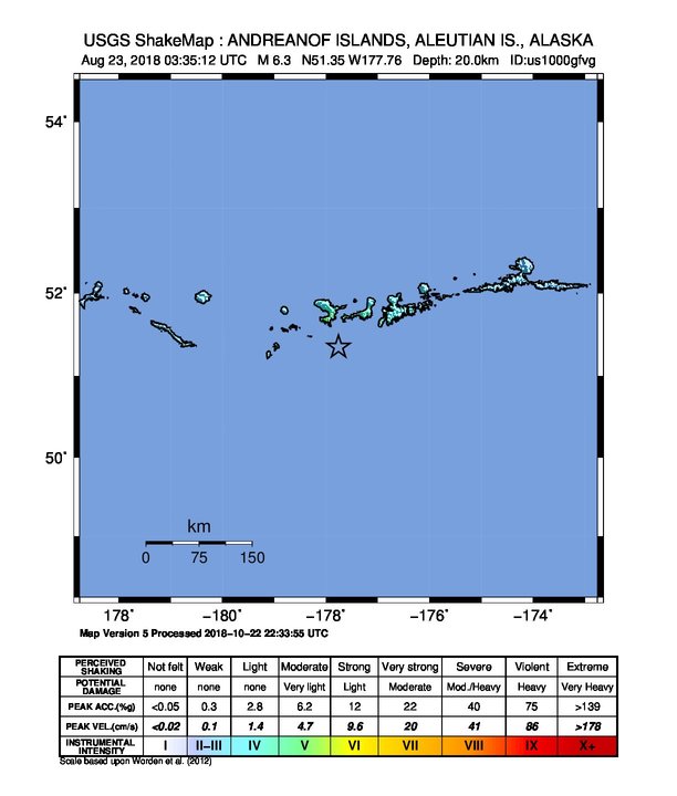
The USGS ShakeMap: shaking estimated from seismic stations and the quake’s size, on the Modified Mercalli intensity scale.
- Strongest estimated
- V, moderate shaking
- Peak ground acceleration
- 1091.0% of gravity
- Peak ground velocity
- 6.4 cm/s
- Map
- Automatic
Did you feel it?
No one has reported feeling this quake to the USGS.
Estimated impact
The USGS PAGER system estimates deaths and economic losses from the shaking and the population and buildings exposed to it.
- Alert level
- Green: little or no damage or loss of life expected
| Range | Chance |
|---|---|
| Under 1 | 69% |
| 1 to 10 | 29% |
| 10 to 100 | 2% |
| 100 to 1,000 | Under 1% |
| 1,000 to 10,000 | Under 1% |
| 10,000 to 100,000 | Under 1% |
| 100,000 to 10,000,000 | Under 1% |
| Range, million USD | Chance |
|---|---|
| Under 1 | 65% |
| 1 to 10 | 30% |
| 10 to 100 | 4% |
| 100 to 1,000 | Under 1% |
| 1,000 to 10,000 | Under 1% |
| 10,000 to 100,000 | Under 1% |
| 100,000 to 10,000,000 | Under 1% |
Fault motion and ground failure
How the rock slipped, from the moment tensor, and the USGS estimate of landslides and liquefaction.
- Faulting
- Oblique reverse
- Moment magnitude
- 6.3 Mww
- Nodal plane 1
- Strike 270°, dip 29°, rake 121°
- Nodal plane 2
- Strike 56°, dip 65°, rake 74°
How well it is located
Reviewed by a seismologist.
- Location uncertainty
- About 4.7 km horizontally, 1.8 km in depth
- Magnitude uncertainty
- ±0.04
- Depth from
- Operator assigned
- Station coverage gap
- 34°
- Stations used
- 425
Nearby
Within 100 km, magnitude 3.3 and up: 15 in the 60 days after this one and 20 in the 30 days before it.
After
- 3.7127 km WSW of Adak, Alaska · 2962 days ago · 10 km deep · 44 km away
- 5.194 km SW of Adak, Alaska · 2952 days ago · 35 km deep · 6 km away
- 3.395 km SW of Adak, Alaska · 2952 days ago · 29 km deep · 13 km away
- 3.6161 km SW of Adak, Alaska · 2952 days ago · 34 km deep · 66 km away
- 3.8165 km W of Adak, Alaska · 2950 days ago · 11 km deep · 99 km away
- 3.3114 km SW of Adak, Alaska · 2950 days ago · 42 km deep · 17 km away
- 3.360 km SSE of Adak, Alaska · 2950 days ago · 35 km deep · 99 km away
- 3.8102 km WSW of Adak, Alaska · 2948 days ago · 6 km deep · 33 km away
- 3.7168 km SW of Adak, Alaska · 2942 days ago · 10 km deep · 74 km away
- 4.092 km SW of Adak, Alaska · 2941 days ago · 42 km deep · 6 km away
- 3.6158 km SSW of Adak, Alaska · 2935 days ago · 10 km deep · 84 km away
- 4.547 km WSW of Adak, Alaska · 2932 days ago · 56 km deep · 51 km away
- 3.9124 km W of Adak, Alaska · 2931 days ago · 15 km deep · 62 km away
- 4.8126 km WSW of Adak, Alaska · 2927 days ago · 10 km deep · 53 km away
- 4.180 km SW of Adak, Alaska · 2914 days ago · 40 km deep · 17 km away
Before
- 3.799 km SW of Adak, Alaska · 2962 days ago · 34 km deep · 8 km away
- 3.4105 km SW of Adak, Alaska · 2966 days ago · 30 km deep · 21 km away
- 3.5Andreanof Islands, Aleutian Islands, Alaska · 2967 days ago · 35 km deep · 20 km away
- 3.8102 km SW of Adak, Alaska · 2968 days ago · 27 km deep · 18 km away
- 4.0107 km SW of Adak, Alaska · 2968 days ago · 35 km deep · 10 km away
- 5.4123 km WSW of Adak, Alaska · 2968 days ago · 32 km deep · 28 km away · tsunami flag
- 4.5101 km SW of Adak, Alaska · 2969 days ago · 39 km deep · 6 km away
- 3.9113 km WSW of Adak, Alaska · 2969 days ago · 50 km deep · 25 km away
- 3.5116 km SW of Adak, Alaska · 2969 days ago · 43 km deep · 19 km away
- 3.8114 km SW of Adak, Alaska · 2969 days ago · 30 km deep · 18 km away
- 4.3108 km SW of Adak, Alaska · 2969 days ago · 35 km deep · 12 km away
- 4.2125 km SW of Adak, Alaska · 2969 days ago · 31 km deep · 33 km away
- 6.5108 km WSW of Adak, Alaska · 2969 days ago · 34 km deep · 20 km away · felt by 8 · tsunami flag
- 4.0163 km SW of Adak, Alaska · 2971 days ago · 10 km deep · 66 km away
- 4.244 km SW of Adak, Alaska · 2971 days ago · 72 km deep · 54 km away
- 3.3126 km WSW of Adak, Alaska · 2972 days ago · 18 km deep · 58 km away
- 3.6133 km WSW of Adak, Alaska · 2975 days ago · 3 km deep · 45 km away
- 3.6130 km W of Adak, Alaska · 2977 days ago · 35 km deep · 64 km away
- 3.3128 km WSW of Adak, Alaska · 2982 days ago · 16 km deep · 48 km away
- 3.359 km SSW of Adak, Alaska · 2991 days ago · 35 km deep · 48 km away
Earthquakes todayAlaska earthquakesLive radar here
Sources
From the USGS Earthquake Hazards Program and its partner networks, event us1000gfvg (also filed as ak20156243, ak018aspadoe, at00pdw9ys, iscgem612634106). Read Fri, Oct 2, 2026, 1:52 AM UTC.