M4.4 earthquake 9 km NNE of Sterling, Alaska
A magnitude 4.4 earthquake struck 9 km NNE of Sterling, Alaska on Fri, Nov 17, 2017, 12:16 PM AKST (21:16 UTC), 49 km (31 mi) below the surface.
Map
Where this earthquake was located, with the others nearby. Select one for its page.
The earthquake
- Magnitude
- 4.4 (Mw, moment), light
- Magnitude from
- Alaska Earthquake Center
- Local time
- UTC
- 2017-11-17 21:16:35 UTC
- Depth
- 49.1 km (30.5 mi), shallow
- Epicenter
- 60.620° N, 150.711° W
- Region
- Alaska
- Felt reports
- 217
- Tsunami flag
- Yes: a large quake in an oceanic region
- Status
- Reviewed by a seismologist
Magnitude estimates
Different scales measure different things and differ by a few tenths. The USGS marks one as preferred, and it is the one this page uses.
| Mag. | Scale | Computed by | Notes |
|---|---|---|---|
| 4.4 | Mw, moment | Alaska Earthquake Center | Preferred · Preliminary |
| 4.4 | Mwr, regional moment | USGS National Earthquake Information Center | Reviewed · ±0.031 · 100 stations |
| 4.4 | ML, local (Richter) | NOAA National Tsunami Warning Center | Reviewed · 13 stations |
Tsunami
The USGS flags a quake this large in an oceanic region. The flag does not mean a tsunami happened; the tsunami warning centers decide that, and their messages are below when they issued any.
Current tsunami warnings: tsunami.gov. Warnings in force in the US also appear on our alerts pages.
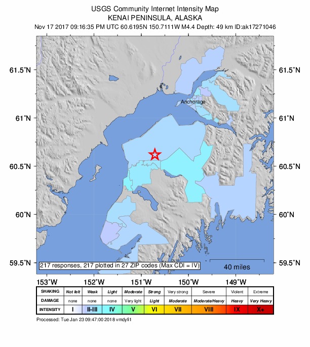
Did you feel it?
217 people reported to the USGS what they felt; the strongest reported shaking was IV, light shaking.
Fault motion and ground failure
How the rock slipped, from the moment tensor, and the USGS estimate of landslides and liquefaction.
- Faulting
- Oblique normal
- Moment magnitude
- 4.4 Mwr
- Nodal plane 1
- Strike 172°, dip 58°, rake -55°
- Nodal plane 2
- Strike 300°, dip 46°, rake -132°
How well it is located
Reviewed by a seismologist.
- Stations used
- 303
Nearest places
Distance and direction from each place to the epicenter, with its forecast.
Nearby
Within 100 km, magnitude 1.5 and up: at least 199 in the 60 days after this one and 111 in the 30 days before it.
After
- 2.18 km N of Sterling, Alaska · 3242 days ago · 55 km deep · 3 km away
- 1.99 km N of Sterling, Alaska · 3242 days ago · 48 km deep · 3 km away
- 1.511 km N of Sterling, Alaska · 3242 days ago · 47 km deep · 4 km away
- 1.610 km N of Sterling, Alaska · 3242 days ago · 45 km deep · 5 km away
- 1.811 km N of Sterling, Alaska · 3242 days ago · 45 km deep · 4 km away
- 1.550 km WNW of Salamatof, Alaska · 3242 days ago · 87 km deep · 82 km away
- 1.611 km WNW of Tyonek, Alaska · 3242 days ago · 73 km deep · 64 km away
- 2.629 km N of Fox River, Alaska · 3241 days ago · 40 km deep · 56 km away
- 1.643 km W of Salamatof, Alaska · 3241 days ago · 80 km deep · 77 km away
- 2.122 km SW of Tyonek, Alaska · 3241 days ago · 72 km deep · 53 km away
- 1.615 km ESE of Kasilof, Alaska · 3240 days ago · 53 km deep · 41 km away
- 1.57 km SSE of Soldotna, Alaska · 3239 days ago · 42 km deep · 27 km away
- 2.513 km ESE of Nikiski, Alaska · 3239 days ago · 61 km deep · 19 km away
- 1.520 km N of Beluga, Alaska · 3239 days ago · 69 km deep · 81 km away
- 1.625 km NE of Point Possession, Alaska · 3239 days ago · 38 km deep · 55 km away
- 1.645 km WNW of Beluga, Alaska · 3239 days ago · 89 km deep · 94 km away
- 1.546 km WNW of Beluga, Alaska · 3239 days ago · 87 km deep · 99 km away
- 1.68 km SSE of Soldotna, Alaska · 3239 days ago · 45 km deep · 26 km away
- 1.635 km NW of Ninilchik, Alaska · 3239 days ago · 89 km deep · 92 km away
- 1.613 km ESE of Clam Gulch, Alaska · 3238 days ago · 58 km deep · 55 km away
- 2.314 km W of Anchorage, Alaska · 3238 days ago · 15 km deep · 74 km away
- 1.512 km E of Kasilof, Alaska · 3238 days ago · 56 km deep · 38 km away
- 1.539 km NW of Ninilchik, Alaska · 3238 days ago · 81 km deep · 92 km away
- 3.12 km ESE of Ninilchik, Alaska · 3238 days ago · 70 km deep · 82 km away
- 1.525 km ESE of Kasilof, Alaska · 3238 days ago · 46 km deep · 40 km away
- 1.660 km W of Salamatof, Alaska · 3238 days ago · 93 km deep · 94 km away
- 2.110 km N of Sterling, Alaska · 3237 days ago · 46 km deep · 3 km away
- 2.09 km WSW of Clam Gulch, Alaska · 3237 days ago · 64 km deep · 65 km away
- 1.620 km W of Hope, Alaska · 3236 days ago · 39 km deep · 52 km away
- 2.138 km WNW of Clam Gulch, Alaska · 3236 days ago · 87 km deep · 78 km away · felt by 1
- 2.024 km W of Point MacKenzie, Alaska · 3235 days ago · 45 km deep · 79 km away
- 1.632 km WNW of Tyonek, Alaska · 3235 days ago · 78 km deep · 81 km away
- 1.818 km N of Nikiski, Alaska · 3235 days ago · 76 km deep · 40 km away
- 1.515 km ESE of Clam Gulch, Alaska · 3234 days ago · 64 km deep · 56 km away
- 1.614 km NW of Beluga, Alaska · 3234 days ago · 67 km deep · 75 km away
- 1.513 km W of Tyonek, Alaska · 3234 days ago · 70 km deep · 61 km away
- 2.114 km WNW of Tyonek, Alaska · 3234 days ago · 75 km deep · 68 km away
- 2.16 km NE of Moose Pass, Alaska · 3234 days ago · 27 km deep · 78 km away
- 3.044 km NW of Ninilchik, Alaska · 3233 days ago · 89 km deep · 96 km away · felt by 1
- 1.544 km WNW of Clam Gulch, Alaska · 3233 days ago · 77 km deep · 83 km away
- 1.763 km WNW of Nikiski, Alaska · 3233 days ago · 106 km deep · 95 km away
- 1.542 km NW of Beluga, Alaska · 3232 days ago · 78 km deep · 100 km away
- 1.555 km W of Salamatof, Alaska · 3232 days ago · 89 km deep · 89 km away
- 1.514 km ESE of Point Possession, Alaska · 3232 days ago · 42 km deep · 31 km away
- 1.815 km S of Hope, Alaska · 3232 days ago · 32 km deep · 60 km away
- 1.621 km ENE of Beluga, Alaska · 3232 days ago · 15 km deep · 66 km away
- 1.520 km SSW of Point Possession, Alaska · 3231 days ago · 58 km deep · 17 km away
- 1.515 km SE of Funny River, Alaska · 3231 days ago · 43 km deep · 25 km away
- 1.541 km W of Nikiski, Alaska · 3231 days ago · 85 km deep · 74 km away
- 1.836 km WNW of Nikiski, Alaska · 3231 days ago · 83 km deep · 68 km away
- 1.69 km W of Moose Pass, Alaska · 3231 days ago · 32 km deep · 66 km away
- 1.636 km WNW of Tyonek, Alaska · 3231 days ago · 78 km deep · 86 km away
- 1.519 km SW of Tyonek, Alaska · 3231 days ago · 62 km deep · 52 km away
- 2.017 km ESE of Ninilchik, Alaska · 3231 days ago · 68 km deep · 79 km away
- 3.113 km E of Ninilchik, Alaska · 3230 days ago · 78 km deep · 73 km away
- 2.035 km W of Nikiski, Alaska · 3230 days ago · 86 km deep · 68 km away
- 1.66 km ESE of Crown Point, Alaska · 3230 days ago · 15 km deep · 83 km away
- 1.639 km W of Salamatof, Alaska · 3230 days ago · 89 km deep · 73 km away
- 1.821 km W of Salamatof, Alaska · 3229 days ago · 77 km deep · 55 km away
- 1.812 km S of Tyonek, Alaska · 3229 days ago · 71 km deep · 44 km away
The first 60 of at least 199.
Before
- 1.530 km WSW of Tyonek, Alaska · 3243 days ago · 81 km deep · 61 km away
- 1.614 km WSW of Tyonek, Alaska · 3243 days ago · 77 km deep · 56 km away
- 1.519 km NE of Point Possession, Alaska · 3243 days ago · 19 km deep · 49 km away
- 1.822 km E of Sterling, Alaska · 3244 days ago · 38 km deep · 21 km away
- 1.639 km W of Kalifornsky, Alaska · 3244 days ago · 91 km deep · 72 km away
- 1.515 km NW of Nikiski, Alaska · 3245 days ago · 69 km deep · 47 km away
- 1.614 km NW of Point Possession, Alaska · 3245 days ago · 53 km deep · 46 km away
- 1.920 km NE of Nikiski, Alaska · 3245 days ago · 57 km deep · 31 km away
- 2.223 km S of Funny River, Alaska · 3245 days ago · 67 km deep · 37 km away
- 1.966 km WNW of Nikiski, Alaska · 3245 days ago · 125 km deep · 99 km away
- 1.652 km NW of Ninilchik, Alaska · 3245 days ago · 92 km deep · 99 km away
- 1.60 km WNW of Ridgeway, Alaska · 3245 days ago · 47 km deep · 23 km away
- 1.532 km W of Salamatof, Alaska · 3245 days ago · 77 km deep · 66 km away
- 1.98 km S of Clam Gulch, Alaska · 3245 days ago · 47 km deep · 64 km away
- 1.611 km SE of Anchorage, Alaska · 3246 days ago · 36 km deep · 79 km away
- 2.610 km SE of Anchorage, Alaska · 3246 days ago · 25 km deep · 77 km away · felt by 2
- 1.57 km SSW of Kenai, Alaska · 3246 days ago · 57 km deep · 35 km away
- 1.852 km W of Salamatof, Alaska · 3246 days ago · 85 km deep · 85 km away
- 1.622 km W of Cooper Landing, Alaska · 3246 days ago · 43 km deep · 32 km away
- 1.639 km WNW of Ninilchik, Alaska · 3246 days ago · 92 km deep · 97 km away
Earthquakes todayAlaska earthquakesLive radar here
Sources
From the USGS Earthquake Hazards Program and its partner networks, event ak017er840ds (also filed as ak17271046, at00ozkz3n, us2000bqq7). Read Sun, Oct 4, 2026, 6:21 AM UTC.