M4.1 earthquake 4 km WNW of Rincón Moreno, Mexico
A magnitude 4.1 earthquake struck 4 km WNW of Rincón Moreno, Mexico on Sun, Dec 31, 2017, 5:42 AM CST (11:42 UTC), 10 km (6 mi) below the surface.
A larger quake followed: M5.0 43 km SSE of El Coyul, Mexico. This one was a foreshock.
Map
Where this earthquake was located, with the others nearby. Select one for its page.
The earthquake
- Magnitude
- 4.1 (mb, body-wave), light
- Magnitude from
- USGS National Earthquake Information Center
- Local time
- UTC
- 2017-12-31 11:42:32 UTC
- Depth
- 10.0 km (6.2 mi), shallow
- Epicenter
- 16.240° N, 95.359° W
- Region
- Mexico
- Felt reports
- 1
- Tsunami flag
- No
- Status
- Reviewed by a seismologist
Did you feel it?
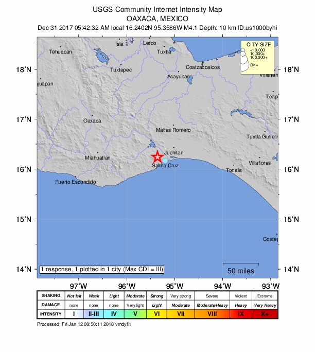
1 person reported to the USGS what they felt; the strongest reported shaking was III, weak shaking.
How well it is located
Reviewed by a seismologist.
- Location uncertainty
- About 8.0 km horizontally, 2.0 km in depth
- Magnitude uncertainty
- ±0.12
- Depth from
- Operator assigned
- Station coverage gap
- 122°
- Stations used
- 36
Nearest places
Distance and direction from each place to the epicenter, with its forecast.
Nearby
Within 100 km, magnitude 1.5 and up: 14 in the 60 days after this one and 6 in the 30 days before it.
After
- 4.635 km SSE of San Mateo del Mar, Mexico · 3196 days ago · 48 km deep · 66 km away · felt by 2
- 4.414 km SSE of Cuauhtémoc, Mexico · 3180 days ago · 112 km deep · 100 km away
- 4.181 km SSE of El Carrizal, Mexico · 3177 days ago · 10 km deep · 96 km away
- 4.241 km S of Colonia Juárez, Mexico · 3177 days ago · 29 km deep · 59 km away · felt by 1
- 4.449 km S of San Mateo del Mar, Mexico · 3169 days ago · 41 km deep · 70 km away · felt by 1
- 4.210 km N of Las Amilpas, Mexico · 3167 days ago · 91 km deep · 82 km away · felt by 1
- 4.361 km S of San Mateo del Mar, Mexico · 3167 days ago · 35 km deep · 82 km away
- 4.39 km SSE of Huazantlán del Río, Mexico · 3165 days ago · 35 km deep · 30 km away
- 5.043 km SSE of El Coyul, Mexico · 3153 days ago · 16 km deep · 86 km away
- 4.662 km SE of El Carrizal, Mexico · 3151 days ago · 39 km deep · 77 km away · felt by 7
- 4.979 km S of San Mateo del Mar, Mexico · 3147 days ago · 35 km deep · 99 km away · felt by 3
- 4.266 km SSE of San Mateo del Mar, Mexico · 3147 days ago · 35 km deep · 88 km away
- 4.220 km SE of Salina Cruz, Mexico · 3142 days ago · 69 km deep · 38 km away
- 4.013 km SSE of El Coyul, Mexico · 3141 days ago · 31 km deep · 67 km away
Before
- 4.06 km NNW of Santo Domingo Chihuitán, Mexico · 3199 days ago · 20 km deep · 48 km away
- 4.05 km W of Santa María Mixtequilla, Mexico · 3200 days ago · 57 km deep · 17 km away
- 4.049 km SSE of San Mateo del Mar, Mexico · 3204 days ago · 35 km deep · 77 km away · felt by 2
- 4.51 km E of Santiago Laollaga, Mexico · 3211 days ago · 19 km deep · 42 km away · felt by 3
- 4.133 km S of El Coyul, Mexico · 3211 days ago · 29 km deep · 82 km away
- 4.515 km SSE of El Carrizal, Mexico · 3216 days ago · 35 km deep · 34 km away
Earthquakes todayMexico earthquakesLive radar here
Sources
From the USGS Earthquake Hazards Program and its partner networks, event us1000byhi. Read Sat, Oct 3, 2026, 12:11 AM UTC.