M4.7 earthquake 83 km ENE of Nikolski, Alaska
A magnitude 4.7 earthquake struck 83 km ENE of Nikolski, Alaska on Sat, Nov 11, 2017, 7:14 AM AKST (16:14 UTC), 68 km (42 mi) below the surface.
Map
Where this earthquake was located, with the others nearby. Select one for its page.
The earthquake
- Magnitude
- 4.7 (mb, body-wave), light
- Magnitude from
- USGS National Earthquake Information Center
- Local time
- UTC
- 2017-11-11 16:14:14 UTC
- Depth
- 67.6 km (42.0 mi), shallow
- Epicenter
- 53.184° N, 167.690° W
- Region
- Alaska
- Felt reports
- 1
- Tsunami flag
- No
- Status
- Reviewed by a seismologist
Magnitude estimates
Different scales measure different things and differ by a few tenths. The USGS marks one as preferred, and it is the one this page uses.
| Mag. | Scale | Computed by | Notes |
|---|---|---|---|
| 4.7 | mb, body-wave | USGS National Earthquake Information Center | Preferred · Reviewed · ±0.046 · 142 stations |
| 4.7 | mb, body-wave | Alaska Earthquake Center | Preliminary |
Did you feel it?
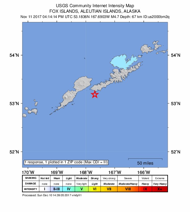
1 person reported to the USGS what they felt; the strongest reported shaking was III, weak shaking.
How well it is located
Reviewed by a seismologist.
- Location uncertainty
- About 5.4 km horizontally, 5.5 km in depth
- Magnitude uncertainty
- ±0.05
- Depth from
- From location
- Station coverage gap
- 93°
- Stations used
- 111
Nearest places
Distance and direction from each place to the epicenter, with its forecast.
Nearby
Within 100 km, magnitude 1.7 and up: 66 in the 60 days after this one and 36 in the 30 days before it.
After
- 1.795 km E of Nikolski, Alaska · 3246 days ago · 14 km deep · 31 km away
- 1.784 km SW of Unalaska, Alaska · 3246 days ago · 18 km deep · 26 km away
- 1.896 km E of Nikolski, Alaska · 3244 days ago · 22 km deep · 25 km away
- 2.424 km S of Unalaska, Alaska · 3244 days ago · 76 km deep · 95 km away
- 2.2103 km E of Nikolski, Alaska · 3243 days ago · 38 km deep · 42 km away
- 2.5102 km E of Nikolski, Alaska · 3243 days ago · 41 km deep · 47 km away
- 2.185 km S of Unalaska, Alaska · 3243 days ago · 15 km deep · 69 km away
- 1.991 km ENE of Nikolski, Alaska · 3239 days ago · 79 km deep · 12 km away
- 1.886 km SW of Unalaska, Alaska · 3239 days ago · 68 km deep · 23 km away
- 4.449 km SE of Nikolski, Alaska · 3235 days ago · 49 km deep · 72 km away
- 2.772 km ENE of Nikolski, Alaska · 3235 days ago · 77 km deep · 15 km away
- 2.480 km S of Unalaska, Alaska · 3233 days ago · 26 km deep · 69 km away
- 2.350 km SE of Nikolski, Alaska · 3232 days ago · 22 km deep · 69 km away
- 1.8Fox Islands, Aleutian Islands, Alaska · 3232 days ago · 15 km deep · 60 km away
- 2.2132 km S of Unalaska, Alaska · 3232 days ago · 5 km deep · 89 km away
- 2.444 km ESE of Nikolski, Alaska · 3231 days ago · 42 km deep · 64 km away
- 3.184 km S of Unalaska, Alaska · 3229 days ago · 49 km deep · 73 km away
- 2.572 km E of Nikolski, Alaska · 3228 days ago · 35 km deep · 34 km away
- 2.860 km SW of Unalaska, Alaska · 3227 days ago · 14 km deep · 48 km away
- 2.666 km NE of Nikolski, Alaska · 3227 days ago · 140 km deep · 40 km away
- 1.721 km WSW of Unalaska, Alaska · 3226 days ago · 9 km deep · 87 km away
- 2.016 km SW of Unalaska, Alaska · 3225 days ago · 7 km deep · 92 km away
- 2.015 km SW of Unalaska, Alaska · 3224 days ago · 5 km deep · 93 km away
- 2.1Fox Islands, Aleutian Islands, Alaska · 3223 days ago · 81 km deep · 77 km away
- 3.947 km SE of Nikolski, Alaska · 3221 days ago · 39 km deep · 71 km away
- 2.387 km SSW of Unalaska, Alaska · 3220 days ago · 26 km deep · 60 km away
- 3.790 km SSW of Unalaska, Alaska · 3220 days ago · 37 km deep · 56 km away
- 2.192 km S of Unalaska, Alaska · 3220 days ago · 26 km deep · 61 km away
- 2.284 km SSW of Unalaska, Alaska · 3220 days ago · 48 km deep · 54 km away
- 3.390 km S of Unalaska, Alaska · 3219 days ago · 28 km deep · 62 km away
- 2.287 km SSW of Unalaska, Alaska · 3219 days ago · 26 km deep · 56 km away
- 2.187 km SSW of Unalaska, Alaska · 3218 days ago · 26 km deep · 58 km away
- 4.080 km E of Nikolski, Alaska · 3217 days ago · 40 km deep · 27 km away
- 2.357 km ESE of Nikolski, Alaska · 3217 days ago · 23 km deep · 60 km away
- 2.168 km SSW of Unalaska, Alaska · 3214 days ago · 62 km deep · 60 km away
- 2.090 km SW of Unalaska, Alaska · 3214 days ago · 77 km deep · 23 km away
- 2.268 km E of Nikolski, Alaska · 3208 days ago · 53 km deep · 24 km away
- 2.185 km SSW of Unalaska, Alaska · 3208 days ago · 26 km deep · 50 km away
- 2.588 km ENE of Nikolski, Alaska · 3207 days ago · 52 km deep · 7 km away
- 2.272 km E of Nikolski, Alaska · 3207 days ago · 38 km deep · 41 km away
- 1.812 km SW of Unalaska, Alaska · 3203 days ago · 82 km deep · 96 km away
- 2.1150 km ESE of Nikolski, Alaska · 3202 days ago · 17 km deep · 98 km away
- 2.0123 km ESE of Nikolski, Alaska · 3201 days ago · 26 km deep · 95 km away
- 2.1130 km S of Unalaska, Alaska · 3201 days ago · 4 km deep · 87 km away
- 2.071 km SSW of Unalaska, Alaska · 3201 days ago · 50 km deep · 63 km away
- 2.382 km SE of Nikolski, Alaska · 3200 days ago · 14 km deep · 87 km away
- 1.774 km SW of Unalaska, Alaska · 3198 days ago · 68 km deep · 35 km away
- 3.196 km S of Unalaska, Alaska · 3198 days ago · 49 km deep · 97 km away
- 3.065 km SSW of Unalaska, Alaska · 3198 days ago · 7 km deep · 52 km away
- 2.084 km SSW of Unalaska, Alaska · 3198 days ago · 18 km deep · 51 km away
- 1.983 km SSW of Unalaska, Alaska · 3197 days ago · 62 km deep · 35 km away
- 2.1106 km SSW of Unalaska, Alaska · 3197 days ago · 12 km deep · 48 km away
- 2.4149 km ESE of Nikolski, Alaska · 3195 days ago · 26 km deep · 100 km away
- 1.776 km SSW of Unalaska, Alaska · 3194 days ago · 56 km deep · 39 km away
- 2.613 km N of Nikolski, Alaska · 3194 days ago · 104 km deep · 77 km away
- 1.767 km SW of Unalaska, Alaska · 3194 days ago · 16 km deep · 42 km away
- 2.129 km SSE of Nikolski, Alaska · 3194 days ago · 44 km deep · 82 km away
- 2.289 km ENE of Nikolski, Alaska · 3192 days ago · 66 km deep · 13 km away
- 2.084 km S of Unalaska, Alaska · 3190 days ago · 13 km deep · 87 km away
- 2.787 km S of Unalaska, Alaska · 3190 days ago · 47 km deep · 63 km away
The first 60 of 66.
Before
- 2.585 km SW of Unalaska, Alaska · 3247 days ago · 70 km deep · 26 km away
- 2.258 km ESE of Nikolski, Alaska · 3248 days ago · 26 km deep · 60 km away
- 1.816 km WSW of Dutch Harbor, Alaska · 3250 days ago · 5 km deep · 95 km away
- 4.2119 km S of Unalaska, Alaska · 3250 days ago · 32 km deep · 74 km away
- 1.992 km SSW of Unalaska, Alaska · 3251 days ago · 26 km deep · 40 km away
- 2.892 km S of Unalaska, Alaska · 3251 days ago · 34 km deep · 61 km away
- 2.0134 km ESE of Nikolski, Alaska · 3251 days ago · 17 km deep · 77 km away
- 1.757 km WSW of Unalaska, Alaska · 3252 days ago · 13 km deep · 53 km away
- 3.689 km SE of Nikolski, Alaska · 3253 days ago · 18 km deep · 97 km away
- 2.3124 km S of Unalaska, Alaska · 3253 days ago · 1 km deep · 81 km away
- 3.6126 km S of Unalaska, Alaska · 3254 days ago · 10 km deep · 85 km away
- 2.6125 km S of Unalaska, Alaska · 3254 days ago · 2 km deep · 83 km away
- 2.0129 km S of Unalaska, Alaska · 3254 days ago · 13 km deep · 87 km away
- 2.1134 km S of Unalaska, Alaska · 3254 days ago · 4 km deep · 83 km away
- 2.2124 km S of Unalaska, Alaska · 3254 days ago · 5 km deep · 88 km away
- 4.6109 km S of Unalaska, Alaska · 3254 days ago · 31 km deep · 68 km away
- 1.894 km ENE of Nikolski, Alaska · 3256 days ago · 86 km deep · 13 km away
- 1.950 km S of Unalaska, Alaska · 3257 days ago · 59 km deep · 80 km away
- 2.053 km SW of Unalaska, Alaska · 3257 days ago · 72 km deep · 56 km away
- 2.7144 km S of Unalaska, Alaska · 3259 days ago · 23 km deep · 95 km away
Earthquakes todayAlaska earthquakesLive radar here
Sources
From the USGS Earthquake Hazards Program and its partner networks, event us2000bm2q (also filed as ak17181672, ak017eh7wafc). Read Thu, Oct 1, 2026, 1:48 PM UTC.