M4.4 earthquake 52 km SW of La Gloria, Mexico
A magnitude 4.4 earthquake struck 52 km SW of La Gloria, Mexico on Sat, Sep 9, 2017, 1:50 PM CDT (18:50 UTC), 57 km (36 mi) below the surface.
A larger quake followed: M5.8 92 km S of San Francisco del Mar Viejo, Mexico. This one was a foreshock.
Map
Where this earthquake was located, with the others nearby. Select one for its page.
The earthquake
- Magnitude
- 4.4 (mb), light
- Local time
- UTC
- 2017-09-09 18:50:43 UTC
- Depth
- 57.4 km (35.6 mi), shallow
- Epicenter
- 15.785° N, 94.426° W
- Region
- Mexico
- Felt reports
- 1
- Tsunami flag
- No
- Status
- Reviewed by a seismologist
Did you feel it?
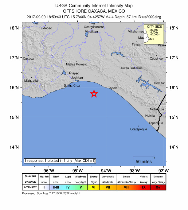
1 person reported to the USGS what they felt; the strongest reported shaking was I, not felt shaking.
How well it is located
Reviewed by a seismologist.
- Location uncertainty
- About 12.2 km horizontally, 10.1 km in depth
- Magnitude uncertainty
- ±0.06
- Depth from
- From location
- Station coverage gap
- 187°, poorly surrounded by stations
- Stations used
- 101
Nearest places
Distance and direction from each place to the epicenter, with its forecast.
Nearby
Within 100 km, magnitude 1.5 and up: at least 199 in the 60 days after this one and 151 in the 30 days before it.
After
- 4.882 km SSE of San Mateo del Mar, Mexico · 3308 days ago · 41 km deep · 52 km away · felt by 2
- 4.273 km S of San Mateo del Mar, Mexico · 3308 days ago · 34 km deep · 56 km away
- 4.4125 km SW of Cabeza de Toro, Mexico · 3308 days ago · 36 km deep · 80 km away
- 4.267 km SSE of El Carrizal, Mexico · 3308 days ago · 20 km deep · 76 km away
- 4.046 km SSE of Salina Cruz, Mexico · 3308 days ago · 35 km deep · 68 km away
- 4.497 km SSW of La Gloria, Mexico · 3308 days ago · 47 km deep · 49 km away
- 4.387 km S of San Francisco del Mar Viejo, Mexico · 3308 days ago · 59 km deep · 44 km away
- 4.391 km S of San Francisco del Mar Viejo, Mexico · 3308 days ago · 32 km deep · 52 km away
- 4.2127 km SSW of Cabeza de Toro, Mexico · 3308 days ago · 28 km deep · 93 km away
- 3.954 km SSE of San Francisco del Mar Viejo, Mexico · 3308 days ago · 42 km deep · 2 km away
- 4.0106 km SSE of El Carrizal, Mexico · 3308 days ago · 60 km deep · 89 km away
- 5.892 km S of San Francisco del Mar Viejo, Mexico · 3308 days ago · 29 km deep · 45 km away · felt by 8
- 4.1107 km SSE of San Mateo del Mar, Mexico · 3308 days ago · 44 km deep · 67 km away
- 4.092 km S of San Mateo del Mar, Mexico · 3308 days ago · 48 km deep · 61 km away
- 4.1104 km S of San Mateo del Mar, Mexico · 3308 days ago · 38 km deep · 73 km away
- 4.147 km SE of El Carrizal, Mexico · 3308 days ago · 34 km deep · 71 km away
- 4.0106 km SW of Doctor Belisario Domínguez (La Barra), Mexico · 3308 days ago · 47 km deep · 78 km away
- 4.3124 km SW of Cabeza de Toro, Mexico · 3308 days ago · 39 km deep · 79 km away
- 4.5124 km S of San Francisco del Mar Viejo, Mexico · 3308 days ago · 25 km deep · 77 km away
- 5.253 km SSE of San Francisco del Mar Viejo, Mexico · 3308 days ago · 58 km deep · 9 km away
- 4.195 km SSE of El Carrizal, Mexico · 3308 days ago · 1 km deep · 71 km away
- 4.957 km SSE of San Mateo del Mar, Mexico · 3308 days ago · 37 km deep · 39 km away
- 4.598 km SW of Cabeza de Toro, Mexico · 3307 days ago · 53 km deep · 55 km away
- 4.2120 km SW of Manuel Ávila Camacho (Ponte Duro), Mexico · 3307 days ago · 13 km deep · 96 km away
- 4.699 km SW of Cabeza de Toro, Mexico · 3307 days ago · 43 km deep · 54 km away
- 4.372 km SE of El Carrizal, Mexico · 3307 days ago · 29 km deep · 65 km away
- 4.360 km SSE of San Francisco del Mar Viejo, Mexico · 3307 days ago · 35 km deep · 13 km away
- 4.334 km S of San Mateo del Mar, Mexico · 3307 days ago · 43 km deep · 59 km away
- 4.5110 km SW of Doctor Belisario Domínguez (La Barra), Mexico · 3307 days ago · 54 km deep · 82 km away
- 4.558 km SE of El Carrizal, Mexico · 3307 days ago · 24 km deep · 73 km away
- 4.3110 km SW of Cabeza de Toro, Mexico · 3307 days ago · 35 km deep · 75 km away
- 4.0117 km SSW of Cabeza de Toro, Mexico · 3307 days ago · 35 km deep · 83 km away
- 4.990 km SSW of Cabeza de Toro, Mexico · 3307 days ago · 59 km deep · 61 km away
- 4.249 km SW of La Gloria, Mexico · 3307 days ago · 57 km deep · 3 km away
- 4.762 km S of San Mateo del Mar, Mexico · 3307 days ago · 52 km deep · 53 km away
- 4.272 km SSE of San Mateo del Mar, Mexico · 3307 days ago · 47 km deep · 50 km away
- 4.290 km SSE of El Carrizal, Mexico · 3307 days ago · 67 km deep · 97 km away
- 4.0106 km SSW of Manuel Ávila Camacho (Ponte Duro), Mexico · 3307 days ago · 39 km deep · 94 km away
- 4.3119 km SSW of La Gloria, Mexico · 3307 days ago · 46 km deep · 71 km away
- 4.497 km SSW of Cabeza de Toro, Mexico · 3307 days ago · 36 km deep · 71 km away
- 4.4100 km S of San Francisco del Mar Viejo, Mexico · 3307 days ago · 38 km deep · 54 km away
- 4.4102 km SW of Cabeza de Toro, Mexico · 3307 days ago · 35 km deep · 68 km away
- 4.288 km SSW of La Gloria, Mexico · 3306 days ago · 50 km deep · 42 km away
- 4.2102 km S of San Francisco del Mar Viejo, Mexico · 3306 days ago · 29 km deep · 61 km away
- 5.089 km SW of Cabeza de Toro, Mexico · 3306 days ago · 33 km deep · 48 km away
- 4.385 km SW of Manuel Ávila Camacho (Ponte Duro), Mexico · 3306 days ago · 46 km deep · 80 km away
- 4.187 km S of San Francisco del Mar Viejo, Mexico · 3306 days ago · 31 km deep · 47 km away
- 5.049 km S of San Mateo del Mar, Mexico · 3306 days ago · 48 km deep · 57 km away
- 4.267 km S of San Francisco del Mar Viejo, Mexico · 3306 days ago · 39 km deep · 29 km away
- 4.497 km SSW of La Gloria, Mexico · 3306 days ago · 42 km deep · 49 km away
- 4.6102 km SW of Manuel Ávila Camacho (Ponte Duro), Mexico · 3306 days ago · 67 km deep · 88 km away
- 5.1101 km SSW of La Gloria, Mexico · 3306 days ago · 17 km deep · 54 km away · felt by 2
- 4.699 km SW of Cabeza de Toro, Mexico · 3306 days ago · 49 km deep · 62 km away
- 4.7near the coast of Oaxaca, Mexico · 3306 days ago · 28 km deep · 74 km away
- 4.5near the coast of Oaxaca, Mexico · 3306 days ago · 35 km deep · 47 km away
- 5.487 km SSW of Manuel Ávila Camacho (Ponte Duro), Mexico · 3306 days ago · 42 km deep · 89 km away · felt by 8
- 4.6103 km SW of Manuel Ávila Camacho (Ponte Duro), Mexico · 3306 days ago · 35 km deep · 90 km away
- 4.4105 km S of San Francisco del Mar Viejo, Mexico · 3306 days ago · 40 km deep · 58 km away
- 4.0132 km S of San Francisco del Mar Viejo, Mexico · 3306 days ago · 28 km deep · 88 km away
- 4.072 km S of San Mateo del Mar, Mexico · 3306 days ago · 22 km deep · 57 km away
The first 60 of at least 199.
Before
- 4.4100 km SW of Cabeza de Toro, Mexico · 3308 days ago · 36 km deep · 55 km away
- 4.297 km SSW of Doctor Belisario Domínguez (La Barra), Mexico · 3308 days ago · 20 km deep · 75 km away
- 4.2108 km SSE of El Carrizal, Mexico · 3308 days ago · 36 km deep · 82 km away
- 4.4115 km S of San Francisco del Mar Viejo, Mexico · 3308 days ago · 39 km deep · 67 km away · felt by 1
- 5.354 km S of San Mateo del Mar, Mexico · 3308 days ago · 32 km deep · 57 km away · felt by 2
- 4.8126 km S of San Francisco del Mar Viejo, Mexico · 3308 days ago · 47 km deep · 79 km away
- 4.673 km SW of Manuel Ávila Camacho (Ponte Duro), Mexico · 3308 days ago · 62 km deep · 73 km away
- 4.285 km S of San Mateo del Mar, Mexico · 3308 days ago · 10 km deep · 63 km away
- 4.1119 km S of San Francisco del Mar Viejo, Mexico · 3308 days ago · 35 km deep · 73 km away
- 4.25 km SE of Chahuite, Mexico · 3308 days ago · 107 km deep · 62 km away
- 4.8102 km SW of Cabeza de Toro, Mexico · 3308 days ago · 31 km deep · 69 km away
- 4.796 km SSW of Cabeza de Toro, Mexico · 3308 days ago · 50 km deep · 66 km away
- 4.396 km SSW of Doctor Belisario Domínguez (La Barra), Mexico · 3308 days ago · 55 km deep · 73 km away
- 4.593 km S of San Francisco del Mar Viejo, Mexico · 3308 days ago · 25 km deep · 54 km away
- 4.724 km SSW of San Francisco del Mar Viejo, Mexico · 3308 days ago · 52 km deep · 44 km away
- 4.971 km S of San Francisco del Mar Viejo, Mexico · 3308 days ago · 47 km deep · 35 km away
- 4.059 km SSW of San Francisco del Mar Viejo, Mexico · 3309 days ago · 26 km deep · 38 km away
- 4.155 km SSE of San Francisco del Mar Viejo, Mexico · 3309 days ago · 68 km deep · 9 km away
- 4.197 km S of San Francisco del Mar Viejo, Mexico · 3309 days ago · 54 km deep · 49 km away
- 4.874 km SW of Manuel Ávila Camacho (Ponte Duro), Mexico · 3309 days ago · 54 km deep · 72 km away
Earthquakes todayMexico earthquakesLive radar here
Sources
From the USGS Earthquake Hazards Program and its partner networks, event us2000aizg. Read Wed, Sep 30, 2026, 11:17 PM UTC.