M3.8 earthquake 9 km NNW of Georgetown, Idaho
A magnitude 3.8 earthquake struck 9 km NNW of Georgetown, Idaho on Tue, Sep 5, 2017, 5:00 PM MDT (23:00 UTC), 6 km (4 mi) below the surface.
A larger quake followed: M5.0 9 km NNW of Georgetown, Idaho. This one was a foreshock.
Map
Where this earthquake was located, with the others nearby. Select one for its page.
The earthquake
- Magnitude
- 3.8 (Mwr, regional moment), minor
- Magnitude from
- USGS National Earthquake Information Center
- Local time
- UTC
- 2017-09-05 23:00:16 UTC
- Depth
- 5.7 km (3.6 mi), shallow
- Epicenter
- 42.560° N, 111.416° W
- Region
- Idaho
- Strongest shaking
- IV, light shaking
- Tsunami flag
- No
- Status
- Reviewed by a seismologist
Magnitude estimates
Different scales measure different things and differ by a few tenths. The USGS marks one as preferred, and it is the one this page uses.
| Mag. | Scale | Computed by | Notes |
|---|---|---|---|
| 3.8 | Mwr, regional moment | USGS National Earthquake Information Center | Preferred · Reviewed · ±0.04 · 59 stations |
| 3.67 | ML, local (Richter) | University of Utah Seismograph Stations | Final · ±0.191 · 13 stations |
Shaking
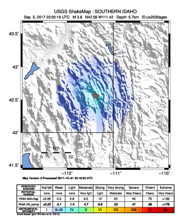
The USGS ShakeMap: shaking estimated from seismic stations and the quake’s size, on the Modified Mercalli intensity scale.
- Strongest estimated
- IV, light shaking
- Peak ground acceleration
- 236.0% of gravity
- Peak ground velocity
- 1.0 cm/s
- Map
- Automatic
Did you feel it?
No one has reported feeling this quake to the USGS.
Fault motion and ground failure
How the rock slipped, from the moment tensor, and the USGS estimate of landslides and liquefaction.
- Faulting
- Normal
- Moment magnitude
- 3.8 Mwr
- Nodal plane 1
- Strike 352°, dip 68°, rake -108°
- Nodal plane 2
- Strike 213°, dip 28°, rake -53°
How well it is located
Reviewed by a seismologist.
- Location uncertainty
- About 1.7 km horizontally, 0.8 km in depth
- Magnitude uncertainty
- ±0.04
- Depth from
- From location
- Station coverage gap
- 116°
- Stations used
- 25
Nearest places
Distance and direction from each place to the epicenter, with its forecast.
Nearby
Within 100 km, magnitude 1.5 and up: at least 200 in the 60 days after this one and at least 200 in the 30 days before it.
After
- 2.710 km NNW of Georgetown, Idaho · 3314 days ago · 11 km deep · 1 km away
- 2.86 km NNW of Georgetown, Idaho · 3314 days ago · 10 km deep · 3 km away
- 2.810 km NNW of Georgetown, Idaho · 3314 days ago · 7 km deep · 1 km away
- 2.97 km NNW of Georgetown, Idaho · 3314 days ago · 14 km deep · 2 km away
- 2.613 km NNW of Georgetown, Idaho · 3314 days ago · 10 km deep · 4 km away
- 1.811 km NNW of Georgetown, Idaho · 3313 days ago · 6 km deep · 2 km away
- 3.212 km NNW of Georgetown, Idaho · 3313 days ago · 7 km deep · 3 km away · felt by 2
- 3.014 km ESE of Soda Springs, Idaho · 3313 days ago · 7 km deep · 5 km away
- 2.611 km NNW of Georgetown, Idaho · 3313 days ago · 2 km deep · 3 km away
- 2.812 km NNW of Georgetown, Idaho · 3313 days ago · 6 km deep · 3 km away
- 2.411 km NNW of Georgetown, Idaho · 3313 days ago · 7 km deep · 2 km away
- 2.612 km NNW of Georgetown, Idaho · 3313 days ago · 10 km deep · 4 km away
- 3.112 km NNW of Georgetown, Idaho · 3313 days ago · 10 km deep · 3 km away
- 3.212 km NNW of Georgetown, Idaho · 3313 days ago · 10 km deep · 3 km away · felt by 3
- 3.013 km ESE of Soda Springs, Idaho · 3313 days ago · 10 km deep · 6 km away
- 2.0southern Idaho · 3313 days ago · 5 km deep · 8 km away
- 3.012 km ESE of Soda Springs, Idaho · 3313 days ago · 7 km deep · 7 km away
- 2.113 km ESE of Soda Springs, Idaho · 3313 days ago · 6 km deep · 8 km away
- 3.413 km ESE of Soda Springs, Idaho · 3313 days ago · 10 km deep · 6 km away · felt by 1
- 4.611 km NNW of Georgetown, Idaho · 3313 days ago · 10 km deep · 3 km away · felt by 69
- 3.013 km ESE of Soda Springs, Idaho · 3313 days ago · 10 km deep · 5 km away
- 2.413 km NNW of Georgetown, Idaho · 3313 days ago · 15 km deep · 4 km away
- 2.510 km NNW of Georgetown, Idaho · 3313 days ago · 3 km deep · 2 km away
- 2.510 km NNW of Georgetown, Idaho · 3313 days ago · 7 km deep · 1 km away
- 2.314 km ESE of Soda Springs, Idaho · 3313 days ago · 6 km deep · 5 km away
- 2.312 km ESE of Soda Springs, Idaho · 3313 days ago · 11 km deep · 7 km away
- 2.810 km NNW of Georgetown, Idaho · 3313 days ago · 10 km deep · 1 km away
- 2.014 km ESE of Soda Springs, Idaho · 3313 days ago · 6 km deep · 6 km away
- 2.613 km NNW of Georgetown, Idaho · 3313 days ago · 10 km deep · 4 km away
- 2.614 km E of Soda Springs, Idaho · 3313 days ago · 10 km deep · 9 km away
- 3.813 km ESE of Soda Springs, Idaho · 3313 days ago · 6 km deep · 5 km away
- 4.213 km NNW of Georgetown, Idaho · 3313 days ago · 7 km deep · 4 km away
- 2.714 km ESE of Soda Springs, Idaho · 3313 days ago · 6 km deep · 6 km away
- 2.613 km NNW of Georgetown, Idaho · 3313 days ago · 10 km deep · 4 km away
- 3.712 km ESE of Soda Springs, Idaho · 3313 days ago · 2 km deep · 7 km away · felt by 2
- 3.812 km NNW of Georgetown, Idaho · 3313 days ago · 10 km deep · 3 km away
- 4.213 km ESE of Soda Springs, Idaho · 3313 days ago · 1 km deep · 6 km away · felt by 12
- 2.413 km ESE of Soda Springs, Idaho · 3313 days ago · 2 km deep · 6 km away
- 2.912 km NNW of Georgetown, Idaho · 3313 days ago · 10 km deep · 3 km away
- 2.813 km ESE of Soda Springs, Idaho · 3313 days ago · 10 km deep · 5 km away
- 2.914 km ESE of Soda Springs, Idaho · 3313 days ago · 6 km deep · 5 km away
- 4.110 km ESE of Soda Springs, Idaho · 3313 days ago · 10 km deep · 8 km away · felt by 2
- 3.912 km NNW of Georgetown, Idaho · 3313 days ago · 5 km deep · 3 km away
- 2.812 km NNW of Georgetown, Idaho · 3313 days ago · 3 km deep · 3 km away
- 2.313 km ESE of Soda Springs, Idaho · 3313 days ago · 5 km deep · 6 km away
- 2.411 km NNW of Georgetown, Idaho · 3313 days ago · 11 km deep · 2 km away
- 1.913 km ESE of Soda Springs, Idaho · 3313 days ago · 6 km deep · 7 km away
- 3.713 km ESE of Soda Springs, Idaho · 3313 days ago · 10 km deep · 6 km away · felt by 2
- 2.310 km NNW of Georgetown, Idaho · 3313 days ago · 7 km deep · 1 km away
- 2.415 km E of Soda Springs, Idaho · 3313 days ago · 6 km deep · 13 km away
- 3.113 km ESE of Soda Springs, Idaho · 3313 days ago · 3 km deep · 5 km away
- 3.012 km E of Soda Springs, Idaho · 3313 days ago · 10 km deep · 13 km away
- 2.714 km ENE of Soda Springs, Idaho · 3313 days ago · 10 km deep · 14 km away
- 2.814 km NNW of Georgetown, Idaho · 3313 days ago · 9 km deep · 5 km away
- 2.410 km NNW of Georgetown, Idaho · 3313 days ago · 7 km deep · 1 km away
- 2.610 km NNW of Georgetown, Idaho · 3313 days ago · 3 km deep · 1 km away
- 3.08 km NNW of Georgetown, Idaho · 3313 days ago · 10 km deep · 2 km away
- 3.214 km NNW of Georgetown, Idaho · 3313 days ago · 6 km deep · 5 km away · felt by 2
- 2.414 km ESE of Soda Springs, Idaho · 3313 days ago · 10 km deep · 7 km away
- 2.612 km NNW of Georgetown, Idaho · 3313 days ago · 2 km deep · 3 km away
The first 60 of at least 200.
Before
- 3.09 km NNW of Georgetown, Idaho · 3314 days ago · 12 km deep · 1 km away
- 2.412 km NNW of Georgetown, Idaho · 3314 days ago · 2 km deep · 3 km away
- 3.812 km NNW of Georgetown, Idaho · 3314 days ago · 5 km deep · 3 km away · felt by 1
- 2.47 km ENE of Soda Springs, Idaho · 3314 days ago · 8 km deep · 16 km away
- 3.013 km NNW of Georgetown, Idaho · 3314 days ago · 12 km deep · 4 km away · felt by 1
- 3.410 km NNW of Georgetown, Idaho · 3314 days ago · 10 km deep · 2 km away
- 4.313 km NNW of Georgetown, Idaho · 3314 days ago · 6 km deep · 4 km away · felt by 16
- 2.49 km NNW of Georgetown, Idaho · 3314 days ago · 11 km deep · 1 km away
- 2.414 km ESE of Soda Springs, Idaho · 3314 days ago · 6 km deep · 7 km away
- 2.911 km NNW of Georgetown, Idaho · 3314 days ago · 13 km deep · 2 km away
- 2.814 km ESE of Soda Springs, Idaho · 3314 days ago · 10 km deep · 5 km away
- 3.214 km ESE of Soda Springs, Idaho · 3314 days ago · 9 km deep · 6 km away
- 3.410 km NNW of Georgetown, Idaho · 3314 days ago · 10 km deep · 2 km away
- 4.312 km NNW of Georgetown, Idaho · 3314 days ago · 10 km deep · 3 km away · felt by 35
- 2.612 km NNW of Georgetown, Idaho · 3314 days ago · 10 km deep · 4 km away
- 2.512 km ESE of Soda Springs, Idaho · 3314 days ago · 10 km deep · 6 km away · felt by 1
- 1.710 km NNW of Georgetown, Idaho · 3314 days ago · -2 km deep · 2 km away
- 2.114 km NNW of Georgetown, Idaho · 3314 days ago · 9 km deep · 5 km away
- 2.112 km NNW of Georgetown, Idaho · 3314 days ago · 1 km deep · 3 km away
- 2.79 km ESE of Soda Springs, Idaho · 3314 days ago · 10 km deep · 10 km away
Earthquakes todayIdaho earthquakesLive radar here
Sources
From the USGS Earthquake Hazards Program and its partner networks, event us2000ages (also filed as uu60235422). Read Fri, Oct 2, 2026, 1:05 PM UTC.