M3.0 earthquake Central Alaska
A magnitude 3.0 earthquake struck in Central Alaska on Tue, Jan 10, 2017, 5:12 AM AKST (14:12 UTC), 22 km (14 mi) below the surface.
A larger quake followed: M3.6 30 km WNW of Minto, Alaska. This one was a foreshock.
Map
Where this earthquake was located, with the others nearby. Select one for its page.
The earthquake
- Magnitude
- 3.0 (ML, local (Richter)), minor
- Magnitude from
- Alaska Earthquake Center
- Local time
- UTC
- 2017-01-10 14:12:10 UTC
- Depth
- 22.3 km (13.9 mi), shallow
- Epicenter
- 64.840° N, 151.022° W
- Region
- Alaska
- Felt reports
- 1
- Tsunami flag
- No
- Status
- Reviewed by a seismologist
Magnitude estimates
Different scales measure different things and differ by a few tenths. The USGS marks one as preferred, and it is the one this page uses.
| Mag. | Scale | Computed by | Notes |
|---|---|---|---|
| 3.0 | ML, local (Richter) | Alaska Earthquake Center | Preferred · Preliminary |
| 3.0 | ML, local (Richter) | USGS National Earthquake Information Center | Reviewed |
What happened
The USGS’s account of the effects of this earthquake.
Felt at Manley Hot Springs.
From the USGS event page for ak017grs4u0. U.S. Geological Survey text and figures are in the public domain.
Did you feel it?
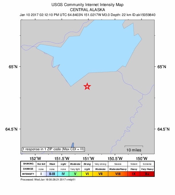
1 person reported to the USGS what they felt; the strongest reported shaking was III, weak shaking.
How well it is located
Reviewed by a seismologist.
- Stations used
- 103
Nearest places
Distance and direction from each place to the epicenter, with its forecast.
Nearby
Within 100 km, magnitude 1.5 and up: 20 in the 60 days after this one and 16 in the 30 days before it.
After
- 1.56 km ENE of Rampart, Alaska · 3552 days ago · 12 km deep · 89 km away
- 1.628 km SE of Minto, Alaska · 3546 days ago · 16 km deep · 96 km away
- 1.626 km NNE of Four Mile Road, Alaska · 3546 days ago · 21 km deep · 96 km away
- 2.947 km SW of Manley Hot Springs, Alaska · 3544 days ago · 22 km deep · 22 km away
- 2.638 km SSE of Manley Hot Springs, Alaska · 3538 days ago · 21 km deep · 34 km away · felt by 1
- 1.836 km SSE of Manley Hot Springs, Alaska · 3537 days ago · 22 km deep · 33 km away
- 1.538 km SSE of Manley Hot Springs, Alaska · 3533 days ago · 22 km deep · 36 km away
- 3.038 km SSE of Manley Hot Springs, Alaska · 3533 days ago · 21 km deep · 33 km away
- 1.736 km SSE of Manley Hot Springs, Alaska · 3533 days ago · 22 km deep · 34 km away
- 3.568 km N of Lake Minchumina, Alaska · 3531 days ago · 20 km deep · 77 km away
- 1.558 km W of Clear, Alaska, Alaska · 3527 days ago · 11 km deep · 73 km away
- 0.7Central Alaska · 3526 days ago · 17 km deep · 28 km away
- 2.627 km SE of Tanana, Alaska · 3526 days ago · 24 km deep · 37 km away
- 1.815 km E of Minto, Alaska · 3526 days ago · 12 km deep · 100 km away
- 3.630 km WNW of Minto, Alaska · 3514 days ago · 18 km deep · 67 km away · felt by 11
- 2.130 km SSE of Rampart, Alaska · 3514 days ago · 10 km deep · 67 km away
- 1.628 km SSE of Rampart, Alaska · 3513 days ago · 16 km deep · 69 km away
- 1.640 km WSW of Clear, Alaska, Alaska · 3513 days ago · 19 km deep · 89 km away
- 1.56 km W of Four Mile Road, Alaska · 3512 days ago · 23 km deep · 88 km away
- 1.517 km NW of Anderson, Alaska · 3502 days ago · 11 km deep · 86 km away
Before
- 1.519 km NW of Four Mile Road, Alaska · 3557 days ago · 18 km deep · 80 km away
- 1.545 km W of Anderson, Alaska · 3561 days ago · 3 km deep · 68 km away
- 3.270 km SSW of Tanana, Alaska · 3561 days ago · 8 km deep · 81 km away
- 1.728 km SSE of Minto, Alaska · 3562 days ago · 19 km deep · 95 km away
- 3.265 km W of Ferry, Alaska · 3563 days ago · 11 km deep · 98 km away
- 1.959 km SSW of Tanana, Alaska · 3563 days ago · 16 km deep · 69 km away
- 2.36 km W of Four Mile Road, Alaska · 3568 days ago · 21 km deep · 88 km away
- 1.926 km W of Anderson, Alaska · 3568 days ago · 19 km deep · 85 km away
- 2.042 km W of Clear, Alaska, Alaska · 3570 days ago · 12 km deep · 87 km away
- 1.927 km W of Anderson, Alaska · 3573 days ago · 17 km deep · 80 km away
- 1.819 km N of Four Mile Road, Alaska · 3577 days ago · 23 km deep · 93 km away
- 2.643 km WSW of Manley Hot Springs, Alaska · 3577 days ago · 17 km deep · 20 km away
- 1.7Central Alaska · 3582 days ago · 13 km deep · 18 km away
- 1.95 km S of Manley Hot Springs, Alaska · 3582 days ago · 16 km deep · 21 km away
- 2.06 km SW of Manley Hot Springs, Alaska · 3582 days ago · 18 km deep · 19 km away
- 2.613 km SSE of Rampart, Alaska · 3584 days ago · 14 km deep · 78 km away
Earthquakes todayAlaska earthquakesLive radar here
Sources
From the USGS Earthquake Hazards Program and its partner networks, event ak017grs4u0 (also filed as ak15059840, us10007scx). Read Mon, Oct 5, 2026, 5:37 AM UTC.