M2.3 earthquake 38 km WNW of Augusta, Montana
A magnitude 2.3 earthquake struck 38 km WNW of Augusta, Montana on Sun, May 14, 2017, 11:33 PM MDT (05:33 UTC), 18 km (11 mi) below the surface.
A larger quake followed: M5.8 11 km SE of Lincoln, Montana. This one was a foreshock.
Map
Where this earthquake was located, with the others nearby. Select one for its page.
The earthquake
- Magnitude
- 2.3 (ML, local (Richter)), micro
- Magnitude from
- USGS National Earthquake Information Center
- Local time
- UTC
- 2017-05-15 05:33:46 UTC
- Depth
- 17.6 km (10.9 mi), shallow
- Epicenter
- 47.623° N, 112.861° W
- Region
- Montana
- Felt reports
- 1
- Tsunami flag
- No
- Status
- Reviewed by a seismologist
Magnitude estimates
Different scales measure different things and differ by a few tenths. The USGS marks one as preferred, and it is the one this page uses.
| Mag. | Scale | Computed by | Notes |
|---|---|---|---|
| 2.3 | ML, local (Richter) | USGS National Earthquake Information Center | Preferred · Reviewed · ±0.091 · 16 stations |
| 2.5 | ML, local (Richter) | Montana Bureau of Mines and Geology | Final · ±0.173 · 11 stations |
Did you feel it?
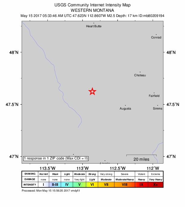
1 person reported to the USGS what they felt; the strongest reported shaking was II, weak shaking.
How well it is located
Reviewed by a seismologist.
- Location uncertainty
- About 4.7 km horizontally, 2.7 km in depth
- Magnitude uncertainty
- ±0.09
- Station coverage gap
- 93°
- Stations used
- 33
Nearest places
Distance and direction from each place to the epicenter, with its forecast.
Nearby
Within 100 km, magnitude 1.5 and up: 120 in the 60 days after this one and 0 in the 30 days before it.
After
- 1.522 km SSE of Swan Lake, Montana · 3421 days ago · 4 km deep · 66 km away
- 2.029 km S of Augusta, Montana · 3415 days ago · 18 km deep · 54 km away
- 1.630 km SSW of Augusta, Montana · 3406 days ago · 22 km deep · 49 km away
- 2.013 km SE of Turtle Lake, Montana · 3400 days ago · 16 km deep · 81 km away
- 1.710 km ESE of Lincoln, Montana · 3392 days ago · 5 km deep · 83 km away
- 1.86 km ENE of Rollins, Montana · 3390 days ago · 1 km deep · 100 km away
- 2.313 km SE of Lincoln, MT · 3379 days ago · 12 km deep · 85 km away
- 5.811 km SE of Lincoln, Montana · 3378 days ago · 12 km deep · 85 km away · felt by 13,377
- 5.015 km S of Lincoln, Montana · 3378 days ago · 15 km deep · 91 km away · felt by 171
- 3.115 km SE of Lincoln, Montana · 3378 days ago · 11 km deep · 88 km away · felt by 3
- 3.311 km ESE of Lincoln, Montana · 3378 days ago · 8 km deep · 84 km away · felt by 6
- 3.514 km SE of Lincoln, Montana · 3378 days ago · 10 km deep · 87 km away
- 4.014 km SSE of Lincoln, Montana · 3378 days ago · 9 km deep · 90 km away · felt by 308
- 3.412 km SE of Lincoln, Montana · 3378 days ago · 10 km deep · 85 km away · felt by 6
- 3.512 km SE of Lincoln, Montana · 3378 days ago · 10 km deep · 87 km away
- 2.67 km NW of Lincoln, Montana · 3378 days ago · 10 km deep · 70 km away · felt by 1
- 4.414 km SE of Lincoln, Montana · 3378 days ago · 10 km deep · 88 km away · felt by 107
- 3.414 km NW of Marysville, Montana · 3378 days ago · 11 km deep · 93 km away · felt by 48
- 2.416 km SE of Lincoln, Montana · 3378 days ago · 13 km deep · 88 km away
- 2.411 km ESE of Lincoln, Montana · 3378 days ago · 7 km deep · 82 km away
- 2.511 km SSE of Lincoln, Montana · 3378 days ago · 13 km deep · 87 km away · felt by 3
- 2.413 km SE of Lincoln, Montana · 3378 days ago · 6 km deep · 86 km away
- 3.39 km SE of Lincoln, Montana · 3378 days ago · 8 km deep · 84 km away
- 2.7Western Montana · 3378 days ago · 9 km deep · 91 km away · felt by 1
- 3.214 km ESE of Lincoln, Montana · 3378 days ago · 20 km deep · 84 km away · felt by 10
- 2.611 km SSE of Lincoln, Montana · 3378 days ago · 9 km deep · 87 km away · felt by 5
- 2.313 km SE of Lincoln, Montana · 3378 days ago · 11 km deep · 88 km away · felt by 9
- 3.312 km SE of Lincoln, Montana · 3378 days ago · 10 km deep · 85 km away · felt by 46
- 2.513 km WNW of Marysville, Montana · 3378 days ago · 11 km deep · 97 km away · felt by 1
- 2.312 km SE of Lincoln, Montana · 3378 days ago · 10 km deep · 85 km away · felt by 6
- 3.712 km ESE of Lincoln, Montana · 3378 days ago · 16 km deep · 84 km away · felt by 122
- 2.314 km ESE of Lincoln, Montana · 3377 days ago · 11 km deep · 84 km away · felt by 4
- 2.413 km SE of Lincoln, Montana · 3377 days ago · 9 km deep · 87 km away · felt by 4
- 2.214 km ESE of Lincoln, Montana · 3377 days ago · 5 km deep · 86 km away
- 2.213 km ESE of Lincoln, Montana · 3377 days ago · 11 km deep · 85 km away
- 2.514 km SE of Lincoln, Montana · 3377 days ago · 11 km deep · 89 km away
- 3.314 km SSE of Lincoln, Montana · 3377 days ago · 9 km deep · 89 km away · felt by 37
- 3.1Western Montana · 3377 days ago · 7 km deep · 81 km away · felt by 6
- 2.212 km ESE of Lincoln, Montana · 3377 days ago · 10 km deep · 84 km away
- 2.37 km SW of Lincoln, Montana · 3377 days ago · 10 km deep · 80 km away · felt by 7
- 2.413 km SE of Lincoln, Montana · 3377 days ago · 10 km deep · 85 km away
- 2.414 km SE of Lincoln, Montana · 3377 days ago · 12 km deep · 88 km away · felt by 3
- 1.813 km SE of Lincoln, Montana · 3376 days ago · 10 km deep · 86 km away
- 2.013 km ESE of Lincoln, Montana · 3376 days ago · 10 km deep · 85 km away · felt by 1
- 2.813 km SE of Lincoln, Montana · 3376 days ago · 8 km deep · 88 km away
- 3.611 km SE of Lincoln, Montana · 3376 days ago · 7 km deep · 85 km away · felt by 63
- 2.614 km SE of Lincoln, Montana · 3376 days ago · 12 km deep · 87 km away
- 3.57 km SE of Lincoln, Montana · 3376 days ago · 9 km deep · 82 km away · felt by 4
- 2.7Western Montana · 3375 days ago · 14 km deep · 89 km away
- 1.97 km SE of Lincoln, Montana · 3375 days ago · 15 km deep · 81 km away
- 2.916 km SE of Lincoln, Montana · 3375 days ago · 15 km deep · 89 km away
- 2.411 km S of Lincoln, Montana · 3375 days ago · 11 km deep · 87 km away
- 3.013 km SE of Lincoln, Montana · 3375 days ago · 9 km deep · 86 km away · felt by 1
- 2.912 km SE of Lincoln, Montana · 3375 days ago · 11 km deep · 86 km away · felt by 1
- 2.513 km SSE of Lincoln, Montana · 3375 days ago · 10 km deep · 88 km away
- 2.514 km SE of Lincoln, Montana · 3375 days ago · 9 km deep · 88 km away
- 2.614 km SE of Lincoln, Montana · 3374 days ago · 14 km deep · 86 km away
- 2.415 km SE of Lincoln, Montana · 3374 days ago · 14 km deep · 88 km away · felt by 2
- 2.79 km NNW of Ovando, Montana · 3374 days ago · 11 km deep · 62 km away · felt by 3
- 2.315 km SE of Lincoln, Montana · 3374 days ago · 14 km deep · 87 km away
The first 60 of 120.
Earthquakes todayMontana earthquakesLive radar here
Sources
From the USGS Earthquake Hazards Program and its partner networks, event us10008shz (also filed as mb80209194). Read Mon, Oct 5, 2026, 3:51 AM UTC.