M4.9 earthquake 82 km SW of Atka, Alaska
A magnitude 4.9 earthquake struck 82 km SW of Atka, Alaska on Sat, Dec 9, 2017, 8:37 AM HAST (18:37 UTC), 52 km (33 mi) below the surface.
Map
Where this earthquake was located, with the others nearby. Select one for its page.
The earthquake
- Magnitude
- 4.9 (mb, body-wave), light
- Magnitude from
- USGS National Earthquake Information Center
- Local time
- UTC
- 2017-12-09 18:37:36 UTC
- Depth
- 52.5 km (32.6 mi), shallow
- Epicenter
- 51.739° N, 175.139° W
- Region
- Alaska
- Strongest shaking
- III, weak shaking
- Tsunami flag
- No
- Status
- Reviewed by a seismologist
Magnitude estimates
Different scales measure different things and differ by a few tenths. The USGS marks one as preferred, and it is the one this page uses.
| Mag. | Scale | Computed by | Notes |
|---|---|---|---|
| 4.9 | mb, body-wave | USGS National Earthquake Information Center | Preferred · Reviewed · ±0.027 · 433 stations |
| 5.1 | Mw, moment | ISC-GEM global catalog | Final · ±0.1 |
| 4.9 | mb, body-wave | Alaska Earthquake Center | Preliminary |
Shaking
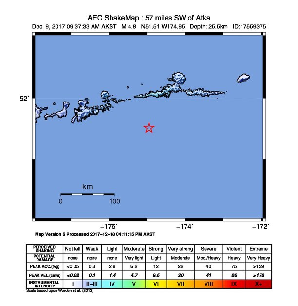
The USGS ShakeMap: shaking estimated from seismic stations and the quake’s size, on the Modified Mercalli intensity scale.
- Strongest estimated
- III, weak shaking
- Map
- Automatic
Did you feel it?
No one has reported feeling this quake to the USGS.
How well it is located
Reviewed by a seismologist.
- Location uncertainty
- About 4.9 km horizontally, 5.4 km in depth
- Magnitude uncertainty
- ±0.03
- Depth from
- From location
- Station coverage gap
- 78°
- Stations used
- 288
Nearby
Within 100 km, magnitude 1.9 and up: 121 in the 60 days after this one and 52 in the 30 days before it.
After
- 2.585 km SW of Atka, Alaska · 3218 days ago · 31 km deep · 16 km away
- 2.588 km SW of Atka, Alaska · 3218 days ago · 26 km deep · 20 km away
- 2.2Andreanof Islands, Aleutian Islands, Alaska · 3218 days ago · 40 km deep · 26 km away
- 2.186 km SW of Atka, Alaska · 3218 days ago · 49 km deep · 18 km away
- 2.3102 km SSE of Adak, Alaska · 3216 days ago · 6 km deep · 95 km away
- 2.228 km SSW of Atka, Alaska · 3215 days ago · 57 km deep · 59 km away
- 2.3Andreanof Islands, Aleutian Islands, Alaska · 3215 days ago · 23 km deep · 91 km away
- 2.244 km SSE of Adak, Alaska · 3215 days ago · 26 km deep · 85 km away
- 2.153 km ESE of Adak, Alaska · 3214 days ago · 54 km deep · 58 km away
- 3.072 km SW of Atka, Alaska · 3214 days ago · 53 km deep · 9 km away
- 2.196 km SSW of Atka, Alaska · 3214 days ago · 26 km deep · 34 km away
- 2.280 km ESE of Adak, Alaska · 3214 days ago · 25 km deep · 44 km away
- 2.817 km SW of Atka, Alaska · 3213 days ago · 206 km deep · 65 km away
- 2.260 km SE of Adak, Alaska · 3212 days ago · 28 km deep · 66 km away
- 2.388 km ESE of Adak, Alaska · 3212 days ago · 49 km deep · 43 km away
- 2.057 km ESE of Adak, Alaska · 3212 days ago · 55 km deep · 52 km away
- 4.196 km SSE of Adak, Alaska · 3211 days ago · 34 km deep · 100 km away
- 3.789 km SW of Atka, Alaska · 3206 days ago · 55 km deep · 11 km away
- 3.340 km SSE of Adak, Alaska · 3206 days ago · 38 km deep · 89 km away
- 2.540 km SE of Atka, Alaska · 3204 days ago · 167 km deep · 99 km away
- 3.087 km SSW of Atka, Alaska · 3203 days ago · 9 km deep · 58 km away
- 2.578 km SSE of Adak, Alaska · 3203 days ago · 41 km deep · 98 km away
- 2.170 km SW of Atka, Alaska · 3203 days ago · 53 km deep · 18 km away
- 3.933 km NW of Atka, Alaska · 3203 days ago · 160 km deep · 87 km away
- 2.484 km ESE of Adak, Alaska · 3203 days ago · 64 km deep · 41 km away
- 2.786 km NE of Adak, Alaska · 3202 days ago · 151 km deep · 100 km away
- 2.936 km SE of Atka, Alaska · 3202 days ago · 172 km deep · 98 km away
- 2.678 km ESE of Adak, Alaska · 3202 days ago · 50 km deep · 36 km away
- 2.038 km SE of Atka, Alaska · 3201 days ago · 6 km deep · 99 km away
- 2.289 km S of Atka, Alaska · 3201 days ago · 7 km deep · 63 km away
- 2.164 km ESE of Adak, Alaska · 3201 days ago · 37 km deep · 52 km away
- 2.2119 km SSW of Atka, Alaska · 3201 days ago · 17 km deep · 54 km away
- 2.448 km W of Atka, Alaska · 3200 days ago · 23 km deep · 52 km away
- 3.0113 km SSW of Atka, Alaska · 3200 days ago · 13 km deep · 45 km away
- 2.269 km NE of Adak, Alaska · 3200 days ago · 175 km deep · 85 km away
- 2.260 km SSW of Atka, Alaska · 3199 days ago · 41 km deep · 39 km away
- 2.1117 km SSW of Atka, Alaska · 3197 days ago · 2 km deep · 51 km away
- 2.068 km SSE of Atka, Alaska · 3197 days ago · 19 km deep · 93 km away
- 1.9Andreanof Islands, Aleutian Islands, Alaska · 3196 days ago · 7 km deep · 97 km away
- 3.852 km SE of Adak, Alaska · 3196 days ago · 38 km deep · 74 km away
- 2.067 km SSE of Adak, Alaska · 3196 days ago · 12 km deep · 95 km away
- 2.193 km S of Atka, Alaska · 3196 days ago · 41 km deep · 73 km away
- 2.046 km SE of Adak, Alaska · 3194 days ago · 7 km deep · 79 km away
- 1.953 km SSE of Adak, Alaska · 3194 days ago · 13 km deep · 81 km away
- 2.934 km SSW of Atka, Alaska · 3193 days ago · 51 km deep · 59 km away
- 2.152 km SE of Adak, Alaska · 3193 days ago · 54 km deep · 76 km away
- 2.043 km SSW of Atka, Alaska · 3193 days ago · 39 km deep · 56 km away
- 3.977 km SE of Adak, Alaska · 3193 days ago · 30 km deep · 53 km away
- 2.743 km SE of Adak, Alaska · 3193 days ago · 47 km deep · 77 km away
- 2.568 km SSE of Atka, Alaska · 3193 days ago · 22 km deep · 97 km away
- 2.3Andreanof Islands, Aleutian Islands, Alaska · 3192 days ago · 59 km deep · 21 km away
- 2.3112 km SSE of Adak, Alaska · 3190 days ago · 2 km deep · 93 km away
- 2.248 km SE of Adak, Alaska · 3189 days ago · 25 km deep · 78 km away
- 2.3138 km SE of Adak, Alaska · 3189 days ago · 3 km deep · 83 km away
- 2.426 km SE of Atka, Alaska · 3189 days ago · 68 km deep · 86 km away
- 2.246 km S of Adak, Alaska · 3187 days ago · 42 km deep · 99 km away
- 2.095 km ESE of Adak, Alaska · 3187 days ago · 42 km deep · 39 km away
- 2.062 km SE of Adak, Alaska · 3187 days ago · 52 km deep · 58 km away
- 2.163 km SSE of Adak, Alaska · 3186 days ago · 22 km deep · 95 km away
- 1.9118 km SE of Adak, Alaska · 3186 days ago · 25 km deep · 58 km away
The first 60 of 121.
Before
- 2.459 km SSE of Adak, Alaska · 3218 days ago · 22 km deep · 81 km away
- 4.042 km SE of Adak, Alaska · 3218 days ago · 47 km deep · 70 km away
- 2.761 km SW of Atka, Alaska · 3219 days ago · 46 km deep · 22 km away
- 1.975 km SSE of Adak, Alaska · 3220 days ago · 25 km deep · 93 km away
- 2.076 km SSE of Adak, Alaska · 3220 days ago · 9 km deep · 99 km away
- 2.488 km S of Atka, Alaska · 3220 days ago · 17 km deep · 82 km away
- 2.366 km SSE of Adak, Alaska · 3221 days ago · 26 km deep · 83 km away
- 2.5112 km S of Atka, Alaska · 3221 days ago · 25 km deep · 92 km away
- 4.173 km ESE of Adak, Alaska · 3221 days ago · 39 km deep · 44 km away
- 2.988 km S of Atka, Alaska · 3221 days ago · 204 km deep · 70 km away
- 2.370 km SE of Adak, Alaska · 3222 days ago · 26 km deep · 73 km away
- 2.060 km SE of Adak, Alaska · 3222 days ago · 26 km deep · 77 km away
- 2.044 km SSE of Atka, Alaska · 3222 days ago · 52 km deep · 88 km away
- 3.662 km NE of Adak, Alaska · 3222 days ago · 239 km deep · 73 km away
- 3.997 km S of Atka, Alaska · 3222 days ago · 27 km deep · 86 km away
- 2.479 km E of Adak, Alaska · 3223 days ago · 59 km deep · 24 km away
- 2.143 km S of Atka, Alaska · 3224 days ago · 59 km deep · 58 km away
- 2.1145 km SE of Adak, Alaska · 3225 days ago · 2 km deep · 89 km away
- 4.288 km NE of Adak, Alaska · 3225 days ago · 164 km deep · 96 km away
- 2.287 km ESE of Adak, Alaska · 3225 days ago · 57 km deep · 41 km away
Earthquakes todayAlaska earthquakesLive radar here
Sources
From the USGS Earthquake Hazards Program and its partner networks, event us2000c2f3 (also filed as ak17559375, ak017frk9udb, iscgem611594790). Read Thu, Oct 1, 2026, 6:47 PM UTC.