M4.1 earthquake 50 km ENE of Atka, Alaska
A magnitude 4.1 earthquake struck 50 km ENE of Atka, Alaska on Mon, Sep 11, 2017, 11:40 AM HADT (20:40 UTC), 66 km (41 mi) below the surface.
Map
Where this earthquake was located, with the others nearby. Select one for its page.
The earthquake
- Magnitude
- 4.1 (mb, body-wave), light
- Magnitude from
- USGS National Earthquake Information Center
- Local time
- UTC
- 2017-09-11 20:40:50 UTC
- Depth
- 65.7 km (40.8 mi), shallow
- Epicenter
- 52.290° N, 173.477° W
- Region
- Alaska
- Strongest shaking
- III, weak shaking
- Tsunami flag
- No
- Status
- Reviewed by a seismologist
Magnitude estimates
Different scales measure different things and differ by a few tenths. The USGS marks one as preferred, and it is the one this page uses.
| Mag. | Scale | Computed by | Notes |
|---|---|---|---|
| 4.1 | mb, body-wave | USGS National Earthquake Information Center | Preferred · Reviewed · ±0.057 · 86 stations |
| 4.1 | mb, body-wave | Alaska Earthquake Center | Preliminary |
Shaking
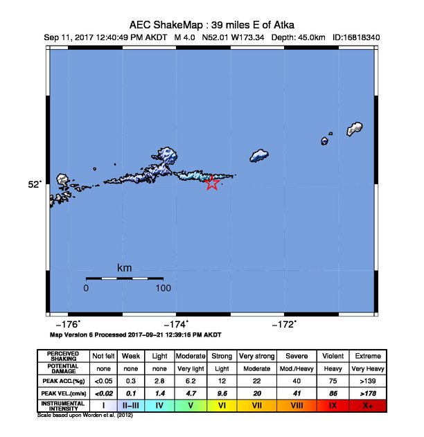
The USGS ShakeMap: shaking estimated from seismic stations and the quake’s size, on the Modified Mercalli intensity scale.
- Strongest estimated
- III, weak shaking
- Map
- Automatic
Did you feel it?
No one has reported feeling this quake to the USGS.
How well it is located
Reviewed by a seismologist.
- Location uncertainty
- About 9.0 km horizontally, 7.2 km in depth
- Magnitude uncertainty
- ±0.06
- Depth from
- From location
- Station coverage gap
- 107°
- Stations used
- 122
Nearby
Within 100 km, magnitude 1.5 and up: 39 in the 60 days after this one and 22 in the 30 days before it.
After
- 1.967 km SE of Atka, Alaska · 3307 days ago · 33 km deep · 51 km away
- 3.4100 km ENE of Atka, Alaska · 3307 days ago · 220 km deep · 55 km away
- 3.010 km SSW of Atka, Alaska · 3307 days ago · 229 km deep · 58 km away
- 1.851 km SSW of Atka, Alaska · 3305 days ago · 29 km deep · 88 km away
- 1.849 km WSW of Atka, Alaska · 3305 days ago · 7 km deep · 98 km away
- 2.811 km SSW of Atka, Alaska · 3305 days ago · 79 km deep · 59 km away
- 3.6118 km NE of Atka, Alaska · 3298 days ago · 22 km deep · 75 km away
- 3.181 km ENE of Atka, Alaska · 3295 days ago · 183 km deep · 35 km away
- 1.545 km WSW of Atka, Alaska · 3293 days ago · 25 km deep · 95 km away
- 2.426 km WNW of Atka, Alaska · 3291 days ago · 175 km deep · 73 km away
- 2.359 km SSW of Atka, Alaska · 3289 days ago · 3 km deep · 94 km away
- 1.8101 km SE of Atka, Alaska · 3289 days ago · 13 km deep · 81 km away
- 1.631 km S of Atka, Alaska · 3289 days ago · 68 km deep · 69 km away
- 1.637 km SE of Atka, Alaska · 3287 days ago · 28 km deep · 40 km away
- 1.644 km SSW of Atka, Alaska · 3287 days ago · 19 km deep · 87 km away
- 2.442 km S of Atka, Alaska · 3286 days ago · 90 km deep · 71 km away
- 2.018 km SW of Atka, Alaska · 3281 days ago · 5 km deep · 66 km away
- 2.762 km S of Atka, Alaska · 3278 days ago · 21 km deep · 85 km away
- 3.325 km N of Atka, Alaska · 3278 days ago · 155 km deep · 52 km away
- 1.949 km WSW of Atka, Alaska · 3277 days ago · 13 km deep · 99 km away
- 1.653 km S of Atka, Alaska · 3275 days ago · 21 km deep · 78 km away
- 2.397 km SE of Atka, Alaska · 3274 days ago · 15 km deep · 72 km away
- 2.161 km SSE of Atka, Alaska · 3273 days ago · 38 km deep · 68 km away
- 2.689 km SSE of Atka, Alaska · 3272 days ago · 28 km deep · 87 km away
- 1.930 km S of Atka, Alaska · 3271 days ago · 64 km deep · 66 km away
- 2.879 km SSE of Atka, Alaska · 3266 days ago · 25 km deep · 78 km away
- 2.634 km NNW of Atka, Alaska · 3262 days ago · 166 km deep · 66 km away
- 2.958 km E of Atka, Alaska · 3261 days ago · 179 km deep · 13 km away
- 4.060 km E of Atka, Alaska · 3257 days ago · 63 km deep · 23 km away
- 2.542 km SW of Atka, Alaska · 3257 days ago · 41 km deep · 86 km away
- 2.218 km WNW of Atka, Alaska · 3256 days ago · 168 km deep · 67 km away
- 1.952 km ESE of Atka, Alaska · 3255 days ago · 67 km deep · 24 km away
- 2.027 km SSE of Atka, Alaska · 3255 days ago · 61 km deep · 54 km away
- 1.866 km ESE of Atka, Alaska · 3255 days ago · 62 km deep · 32 km away
- 2.029 km ESE of Atka, Alaska · 3254 days ago · 19 km deep · 31 km away
- 3.037 km ENE of Atka, Alaska · 3250 days ago · 194 km deep · 17 km away
- 2.053 km SSW of Atka, Alaska · 3249 days ago · 41 km deep · 95 km away
- 3.055 km SE of Atka, Alaska · 3248 days ago · 35 km deep · 51 km away
- 2.455 km WNW of Atka, Alaska · 3247 days ago · 218 km deep · 100 km away
Before
- 3.470 km ENE of Atka, Alaska · 3308 days ago · 96 km deep · 29 km away
- 4.032 km NNW of Atka, Alaska · 3308 days ago · 238 km deep · 63 km away
- 2.077 km SE of Atka, Alaska · 3310 days ago · 13 km deep · 59 km away
- 1.945 km SE of Atka, Alaska · 3311 days ago · 12 km deep · 52 km away
- 2.437 km W of Atka, Alaska · 3311 days ago · 13 km deep · 87 km away
- 2.840 km ESE of Atka, Alaska · 3315 days ago · 168 km deep · 23 km away
- 2.458 km SSE of Atka, Alaska · 3315 days ago · 7 km deep · 72 km away
- 3.979 km S of Atka, Alaska · 3318 days ago · 43 km deep · 97 km away
- 1.746 km SSW of Atka, Alaska · 3321 days ago · 31 km deep · 89 km away
- 3.929 km ESE of Atka, Alaska · 3321 days ago · 71 km deep · 27 km away
- 2.045 km E of Atka, Alaska · 3322 days ago · 13 km deep · 15 km away
- 2.945 km E of Atka, Alaska · 3324 days ago · 174 km deep · 7 km away
- 2.064 km SSE of Atka, Alaska · 3324 days ago · 22 km deep · 69 km away
- 4.247 km NNW of Atka, Alaska · 3326 days ago · 174 km deep · 70 km away
- 3.317 km ESE of Atka, Alaska · 3330 days ago · 66 km deep · 39 km away
- 2.340 km NE of Atka, Alaska · 3331 days ago · 195 km deep · 34 km away
- 1.872 km SE of Atka, Alaska · 3334 days ago · 16 km deep · 69 km away
- 2.5102 km SE of Atka, Alaska · 3334 days ago · 21 km deep · 90 km away
- 2.417 km SE of Atka, Alaska · 3334 days ago · 154 km deep · 44 km away
- 2.133 km SE of Atka, Alaska · 3335 days ago · 2 km deep · 39 km away
Earthquakes todayAlaska earthquakesLive radar here
Sources
From the USGS Earthquake Hazards Program and its partner networks, event us2000akbz (also filed as ak16818340, ak017boenhz7). Read Fri, Oct 2, 2026, 12:01 AM UTC.