M4.3 earthquake 33 km N of Aleneva, Alaska
A magnitude 4.3 earthquake struck 33 km N of Aleneva, Alaska on Wed, Oct 4, 2017, 6:03 PM AKDT (02:03 UTC), 51 km (32 mi) below the surface.
Map
Where this earthquake was located, with the others nearby. Select one for its page.
The earthquake
- Magnitude
- 4.3 (ML, local (Richter)), light
- Magnitude from
- Alaska Earthquake Center
- Local time
- UTC
- 2017-10-05 02:03:58 UTC
- Depth
- 51.1 km (31.8 mi), shallow
- Epicenter
- 58.361° N, 152.868° W
- Region
- Alaska
- Felt reports
- 2
- Strongest shaking
- III, weak shaking
- PAGER alert
- Green
- Tsunami flag
- Yes: a large quake in an oceanic region
- Status
- Reviewed by a seismologist
Magnitude estimates
Different scales measure different things and differ by a few tenths. The USGS marks one as preferred, and it is the one this page uses.
| Mag. | Scale | Computed by | Notes |
|---|---|---|---|
| 4.3 | ML, local (Richter) | Alaska Earthquake Center | Preferred · Preliminary |
| 4.4 | mb, body-wave | USGS National Earthquake Information Center | Reviewed · ±0.06 · 81 stations |
| 4.3 | ML, local (Richter) | NOAA National Tsunami Warning Center | Reviewed · 18 stations |
What happened
The USGS’s account of the effects of this earthquake.
Also felt at Homer.
From the USGS event page for ak017crsm45v. U.S. Geological Survey text and figures are in the public domain.
Tsunami
The USGS flags a quake this large in an oceanic region. The flag does not mean a tsunami happened; the tsunami warning centers decide that, and their messages are below when they issued any.
Current tsunami warnings: tsunami.gov. Warnings in force in the US also appear on our alerts pages.
Shaking
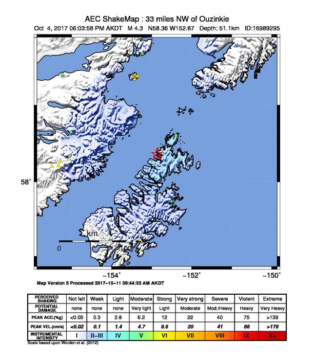
The USGS ShakeMap: shaking estimated from seismic stations and the quake’s size, on the Modified Mercalli intensity scale.
- Strongest estimated
- III, weak shaking
- Map
- Automatic
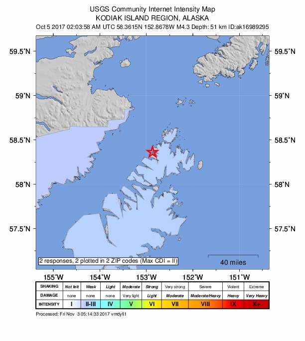
Did you feel it?
2 people reported to the USGS what they felt; the strongest reported shaking was II, weak shaking.
Estimated impact
The USGS PAGER system estimates deaths and economic losses from the shaking and the population and buildings exposed to it.
- Alert level
- Green: little or no damage or loss of life expected
| Range | Chance |
|---|---|
| Under 1 | 69% |
| 1 to 10 | 29% |
| 10 to 100 | 2% |
| 100 to 1,000 | Under 1% |
| 1,000 to 10,000 | Under 1% |
| 10,000 to 100,000 | Under 1% |
| 100,000 to 10,000,000 | Under 1% |
| Range, million USD | Chance |
|---|---|
| Under 1 | 65% |
| 1 to 10 | 30% |
| 10 to 100 | 4% |
| 100 to 1,000 | Under 1% |
| 1,000 to 10,000 | Under 1% |
| 10,000 to 100,000 | Under 1% |
| 100,000 to 10,000,000 | Under 1% |
How well it is located
Reviewed by a seismologist.
- Stations used
- 204
Nearest places
Distance and direction from each place to the epicenter, with its forecast.
Nearby
Within 100 km, magnitude 1.5 and up: 94 in the 60 days after this one and 50 in the 30 days before it.
After
- 1.787 km WSW of Nanwalek, Alaska · 3283 days ago · 74 km deep · 72 km away
- 1.872 km WNW of Aleneva, Alaska · 3282 days ago · 69 km deep · 72 km away
- 1.992 km NW of Aleneva, Alaska · 3282 days ago · 83 km deep · 78 km away
- 1.875 km SSE of Kokhanok, Alaska · 3282 days ago · 102 km deep · 93 km away
- 1.961 km SW of Nanwalek, Alaska · 3281 days ago · 67 km deep · 70 km away
- 1.558 km N of Karluk, Alaska · 3280 days ago · 60 km deep · 88 km away
- 1.662 km NNW of Aleneva, Alaska · 3275 days ago · 64 km deep · 39 km away
- 1.663 km SE of Kokhanok, Alaska · 3274 days ago · 109 km deep · 100 km away
- 1.869 km WSW of Nanwalek, Alaska · 3273 days ago · 80 km deep · 98 km away
- 1.769 km NW of Aleneva, Alaska · 3272 days ago · 73 km deep · 53 km away
- 1.751 km S of Port Graham, Alaska · 3272 days ago · 47 km deep · 87 km away
- 1.660 km NNE of Karluk, Alaska · 3271 days ago · 72 km deep · 86 km away
- 1.922 km WSW of Port Lions, Alaska · 3271 days ago · 57 km deep · 64 km away
- 2.0Southern Alaska · 3270 days ago · 3 km deep · 91 km away
- 2.737 km SW of Nanwalek, Alaska · 3270 days ago · 62 km deep · 90 km away
- 2.536 km SW of Nanwalek, Alaska · 3270 days ago · 61 km deep · 91 km away
- 2.087 km SW of Nanwalek, Alaska · 3269 days ago · 68 km deep · 58 km away
- 1.530 km WSW of Nanwalek, Alaska · 3269 days ago · 70 km deep · 98 km away
- 1.574 km SW of Nanwalek, Alaska · 3269 days ago · 71 km deep · 65 km away
- 1.678 km N of Karluk, Alaska · 3268 days ago · 80 km deep · 79 km away
- 1.776 km N of Aleneva, Alaska · 3267 days ago · 72 km deep · 42 km away
- 1.688 km SW of Nanwalek, Alaska · 3267 days ago · 66 km deep · 59 km away
- 1.673 km WNW of Aleneva, Alaska · 3265 days ago · 68 km deep · 63 km away
- 1.677 km N of Karluk, Alaska · 3264 days ago · 86 km deep · 81 km away
- 2.076 km NNE of Aleneva, Alaska · 3264 days ago · 72 km deep · 44 km away
- 1.697 km NW of Aleneva, Alaska · 3263 days ago · 93 km deep · 85 km away
- 1.793 km NW of Aleneva, Alaska · 3263 days ago · 77 km deep · 70 km away
- 2.283 km N of Aleneva, Alaska · 3263 days ago · 66 km deep · 50 km away
- 1.686 km NW of Aleneva, Alaska · 3262 days ago · 87 km deep · 73 km away
- 2.193 km WSW of Nanwalek, Alaska · 3261 days ago · 66 km deep · 69 km away
- 2.066 km SSE of Kokhanok, Alaska · 3260 days ago · 104 km deep · 98 km away
- 2.052 km SW of Nanwalek, Alaska · 3260 days ago · 56 km deep · 78 km away
- 2.069 km SSE of Port Graham, Alaska · 3259 days ago · 59 km deep · 91 km away
- 2.248 km S of Port Graham, Alaska · 3257 days ago · 46 km deep · 82 km away
- 2.083 km SW of Nanwalek, Alaska · 3257 days ago · 67 km deep · 53 km away
- 2.285 km WSW of Nanwalek, Alaska · 3257 days ago · 70 km deep · 72 km away
- 1.568 km SW of Nanwalek, Alaska · 3256 days ago · 63 km deep · 59 km away
- 2.184 km ENE of Ouzinkie, Alaska · 3255 days ago · 7 km deep · 94 km away
- 2.494 km N of Karluk, Alaska · 3255 days ago · 2 km deep · 91 km away
- 1.690 km NNW of Aleneva, Alaska · 3255 days ago · 74 km deep · 61 km away
- 1.663 km W of Aleneva, Alaska · 3254 days ago · 53 km deep · 70 km away
- 1.758 km NW of Aleneva, Alaska · 3251 days ago · 68 km deep · 44 km away
- 2.165 km ENE of Ouzinkie, Alaska · 3251 days ago · 32 km deep · 80 km away
- 1.776 km WNW of Aleneva, Alaska · 3250 days ago · 86 km deep · 66 km away
- 1.519 km WNW of Aleneva, Alaska · 3250 days ago · 47 km deep · 35 km away
- 4.123 km SW of Womens Bay, Alaska · 3249 days ago · 42 km deep · 93 km away · felt by 5 · tsunami flag
- 2.026 km SW of Womens Bay, Alaska · 3249 days ago · 26 km deep · 95 km away
- 2.026 km SW of Womens Bay, Alaska · 3249 days ago · 30 km deep · 94 km away
- 2.127 km SW of Womens Bay, Alaska · 3249 days ago · 30 km deep · 96 km away
- 2.125 km SSW of Womens Bay, Alaska · 3248 days ago · 38 km deep · 97 km away
- 1.879 km SE of Kokhanok, Alaska · 3248 days ago · 88 km deep · 83 km away
- 2.025 km SW of Womens Bay, Alaska · 3248 days ago · 28 km deep · 94 km away
- 3.524 km SW of Womens Bay, Alaska · 3248 days ago · 30 km deep · 90 km away
- 2.083 km NNW of Aleneva, Alaska · 3248 days ago · 11 km deep · 58 km away
- 2.754 km WSW of Nanwalek, Alaska · 3247 days ago · 69 km deep · 90 km away
- 1.586 km NNW of Aleneva, Alaska · 3247 days ago · 14 km deep · 61 km away
- 2.05 km N of Kodiak Station, Alaska · 3247 days ago · 40 km deep · 62 km away
- 1.868 km NNE of Aleneva, Alaska · 3245 days ago · 7 km deep · 40 km away
- 2.229 km WSW of Aleneva, Alaska · 3244 days ago · 42 km deep · 54 km away
- 1.860 km N of Karluk, Alaska · 3244 days ago · 67 km deep · 88 km away
The first 60 of 94.
Before
- 1.579 km SW of Nanwalek, Alaska · 3285 days ago · 59 km deep · 48 km away
- 1.928 km N of Ouzinkie, Alaska · 3285 days ago · 27 km deep · 34 km away
- 1.840 km SW of Nanwalek, Alaska · 3285 days ago · 73 km deep · 86 km away
- 1.679 km ENE of Ouzinkie, Alaska · 3286 days ago · 13 km deep · 87 km away
- 2.989 km SSE of Kokhanok, Alaska · 3287 days ago · 101 km deep · 82 km away
- 1.939 km N of Larsen Bay, Alaska · 3288 days ago · 54 km deep · 78 km away
- 1.765 km SE of Kokhanok, Alaska · 3288 days ago · 113 km deep · 97 km away
- 1.670 km SE of Kokhanok, Alaska · 3289 days ago · 105 km deep · 93 km away
- 2.047 km WSW of Nanwalek, Alaska · 3289 days ago · 16 km deep · 99 km away
- 1.792 km SE of Kokhanok, Alaska · 3290 days ago · 6 km deep · 71 km away · felt by 1
- 1.791 km SE of Kokhanok, Alaska · 3290 days ago · 7 km deep · 72 km away
- 2.569 km SE of Kokhanok, Alaska · 3290 days ago · 104 km deep · 94 km away
- 1.880 km NW of Aleneva, Alaska · 3290 days ago · 85 km deep · 68 km away
- 1.992 km NNW of Aleneva, Alaska · 3291 days ago · 8 km deep · 64 km away
- 1.672 km SW of Nanwalek, Alaska · 3292 days ago · 67 km deep · 67 km away
- 1.645 km NE of Ouzinkie, Alaska · 3293 days ago · 22 km deep · 48 km away
- 1.681 km N of Aleneva, Alaska · 3293 days ago · 68 km deep · 49 km away
- 1.569 km NW of Aleneva, Alaska · 3294 days ago · 73 km deep · 53 km away
- 1.892 km SSE of Kokhanok, Alaska · 3294 days ago · 84 km deep · 75 km away
- 1.646 km NNE of Aleneva, Alaska · 3295 days ago · 46 km deep · 24 km away
Earthquakes todayAlaska earthquakesLive radar here
Sources
From the USGS Earthquake Hazards Program and its partner networks, event ak017crsm45v (also filed as ak16989295, us2000b19u, at00oxbv2m). Read Fri, Oct 2, 2026, 4:52 PM UTC.