M5.1 earthquake 126 km SE of Akutan, Alaska
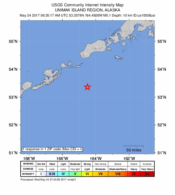
A magnitude 5.1 earthquake struck 126 km SE of Akutan, Alaska on Tue, May 23, 2017, 10:35 PM AKDT (06:35 UTC), 10 km (6 mi) below the surface.
Map
Where this earthquake was located, with the others nearby. Select one for its page.
The earthquake
- Magnitude
- 5.1 (Mww, W-phase moment), moderate
- Magnitude from
- USGS National Earthquake Information Center
- Local time
- UTC
- 2017-05-24 06:35:17 UTC
- Depth
- 10.0 km (6.2 mi), shallow
- Epicenter
- 53.307° N, 164.454° W
- Region
- Alaska
- Felt reports
- 1
- Tsunami flag
- Yes: a large quake in an oceanic region
- Status
- Reviewed by a seismologist
Magnitude estimates
Different scales measure different things and differ by a few tenths. The USGS marks one as preferred, and it is the one this page uses.
| Mag. | Scale | Computed by | Notes |
|---|---|---|---|
| 5.1 | Mww, W-phase moment | USGS National Earthquake Information Center | Preferred · Reviewed · ±0.073 · 18 stations |
| 5.2 | Mw, moment | ISC-GEM global catalog | Final · ±0.1 |
| 5.2 | Mw, moment | Alaska Earthquake Center | Preliminary |
| 5.0 | Mi | NOAA National Tsunami Warning Center | Reviewed · 7 stations |
| 5.2 | Mwb, body-wave moment | USGS National Earthquake Information Center | Moment tensor · Reviewed |
Tsunami
The USGS flags a quake this large in an oceanic region. The flag does not mean a tsunami happened; the tsunami warning centers decide that, and their messages are below when they issued any.
Current tsunami warnings: tsunami.gov. Warnings in force in the US also appear on our alerts pages.
Did you feel it?
1 person reported to the USGS what they felt; the strongest reported shaking was I, not felt shaking.
Fault motion and ground failure
How the rock slipped, from the moment tensor, and the USGS estimate of landslides and liquefaction.
- Faulting
- Reverse (thrust)
- Moment magnitude
- 5.1 Mww
- Nodal plane 1
- Strike 242°, dip 34°, rake 94°
- Nodal plane 2
- Strike 58°, dip 56°, rake 87°
How well it is located
Reviewed by a seismologist.
- Location uncertainty
- About 5.6 km horizontally, 1.8 km in depth
- Magnitude uncertainty
- ±0.07
- Depth from
- Operator assigned
- Station coverage gap
- 132°
- Stations used
- 195
Nearest places
Distance and direction from each place to the epicenter, with its forecast.
Nearby
Within 100 km, magnitude 2.1 and up: 79 in the 60 days after this one and 30 in the 30 days before it.
After
- 2.5130 km SE of Akutan, Alaska · 3418 days ago · 80 km deep · 7 km away
- 2.6140 km SE of Akutan, Alaska · 3418 days ago · 26 km deep · 14 km away
- 2.5133 km SE of Akutan, Alaska · 3418 days ago · 7 km deep · 8 km away
- 2.593 km S of False Pass, Alaska · 3418 days ago · 36 km deep · 98 km away
- 2.8137 km SE of Akutan, Alaska · 3418 days ago · 59 km deep · 11 km away
- 2.7133 km SE of Akutan, Alaska · 3418 days ago · 62 km deep · 7 km away
- 2.286 km SE of Akutan, Alaska · 3417 days ago · 52 km deep · 44 km away
- 3.0133 km SE of Akutan, Alaska · 3417 days ago · 42 km deep · 10 km away
- 3.1133 km SE of Akutan, Alaska · 3416 days ago · 37 km deep · 8 km away
- 2.4148 km SE of Akutan, Alaska · 3416 days ago · 25 km deep · 24 km away
- 2.5151 km SE of Akutan, Alaska · 3416 days ago · 35 km deep · 25 km away
- 2.3130 km SE of Akutan, Alaska · 3416 days ago · 17 km deep · 8 km away
- 2.2140 km SE of Akutan, Alaska · 3416 days ago · 25 km deep · 13 km away
- 2.353 km ESE of Akutan, Alaska · 3416 days ago · 144 km deep · 84 km away
- 2.5136 km SE of Akutan, Alaska · 3415 days ago · 10 km deep · 10 km away
- 2.2147 km SE of Akutan, Alaska · 3415 days ago · 21 km deep · 21 km away
- 2.5147 km SE of Akutan, Alaska · 3415 days ago · 21 km deep · 20 km away
- 2.1140 km SE of Akutan, Alaska · 3414 days ago · 12 km deep · 14 km away
- 2.9161 km S of False Pass, Alaska · 3414 days ago · 15 km deep · 56 km away
- 2.5159 km S of False Pass, Alaska · 3414 days ago · 8 km deep · 55 km away
- 2.6167 km S of False Pass, Alaska · 3414 days ago · 25 km deep · 57 km away
- 2.2167 km ESE of Akutan, Alaska · 3414 days ago · 18 km deep · 56 km away
- 2.2162 km S of False Pass, Alaska · 3414 days ago · 6 km deep · 56 km away
- 2.4163 km S of False Pass, Alaska · 3414 days ago · 19 km deep · 57 km away
- 4.1159 km S of False Pass, Alaska · 3414 days ago · 10 km deep · 55 km away
- 4.2162 km S of False Pass, Alaska · 3414 days ago · 10 km deep · 58 km away
- 2.8165 km S of False Pass, Alaska · 3414 days ago · 10 km deep · 56 km away
- 2.1162 km ESE of Akutan, Alaska · 3414 days ago · 10 km deep · 53 km away
- 2.1166 km S of False Pass, Alaska · 3414 days ago · 23 km deep · 60 km away
- 2.2160 km S of False Pass, Alaska · 3414 days ago · 10 km deep · 55 km away
- 2.1160 km S of False Pass, Alaska · 3414 days ago · 26 km deep · 55 km away
- 2.5161 km S of False Pass, Alaska · 3414 days ago · 7 km deep · 60 km away
- 2.1188 km SE of Akutan, Alaska · 3413 days ago · 10 km deep · 63 km away
- 3.2169 km S of False Pass, Alaska · 3413 days ago · 10 km deep · 61 km away
- 2.4159 km S of False Pass, Alaska · 3412 days ago · 24 km deep · 65 km away
- 3.5159 km S of False Pass, Alaska · 3412 days ago · 32 km deep · 54 km away
- 3.7143 km ESE of Akutan, Alaska · 3412 days ago · 10 km deep · 50 km away
- 2.4161 km ESE of Akutan, Alaska · 3412 days ago · 37 km deep · 53 km away
- 2.2158 km ESE of Akutan, Alaska · 3412 days ago · 38 km deep · 52 km away
- 2.3145 km SE of Akutan, Alaska · 3412 days ago · 18 km deep · 19 km away
- 2.462 km ESE of Akutan, Alaska · 3407 days ago · 60 km deep · 72 km away
- 2.2157 km S of False Pass, Alaska · 3405 days ago · 19 km deep · 55 km away
- 3.2138 km SE of Akutan, Alaska · 3404 days ago · 10 km deep · 15 km away
- 2.1138 km SSE of Unalaska, Alaska · 3404 days ago · 23 km deep · 85 km away
- 3.2157 km S of False Pass, Alaska · 3402 days ago · 23 km deep · 55 km away
- 2.3154 km S of False Pass, Alaska · 3400 days ago · 6 km deep · 53 km away
- 2.5164 km S of False Pass, Alaska · 3400 days ago · 26 km deep · 59 km away
- 2.4165 km S of False Pass, Alaska · 3400 days ago · 26 km deep · 62 km away
- 2.376 km SE of Akutan, Alaska · 3400 days ago · 198 km deep · 51 km away
- 2.6127 km SSE of Unalaska, Alaska · 3399 days ago · 26 km deep · 96 km away
- 2.436 km SE of Akutan, Alaska · 3399 days ago · 64 km deep · 91 km away
- 2.188 km SE of Akutan, Alaska · 3399 days ago · 54 km deep · 38 km away
- 2.149 km SE of Akutan, Alaska · 3398 days ago · 55 km deep · 77 km away
- 2.277 km ESE of Akutan, Alaska · 3396 days ago · 57 km deep · 66 km away
- 2.4160 km ESE of Akutan, Alaska · 3395 days ago · 73 km deep · 54 km away
- 2.6167 km S of False Pass, Alaska · 3395 days ago · 37 km deep · 59 km away
- 2.164 km ESE of Akutan, Alaska · 3395 days ago · 99 km deep · 83 km away
- 2.2126 km S of False Pass, Alaska · 3395 days ago · 8 km deep · 73 km away
- 2.292 km SSW of False Pass, Alaska · 3394 days ago · 20 km deep · 94 km away
- 2.1117 km SSW of False Pass, Alaska · 3393 days ago · 19 km deep · 68 km away
The first 60 of 79.
Before
- 2.5101 km SE of Unalaska, Alaska · 3419 days ago · 10 km deep · 77 km away
- 2.6160 km ESE of Akutan, Alaska · 3419 days ago · 14 km deep · 53 km away
- 3.1170 km S of False Pass, Alaska · 3419 days ago · 25 km deep · 61 km away
- 2.4105 km S of False Pass, Alaska · 3425 days ago · 15 km deep · 99 km away
- 3.5185 km SSE of Unalaska, Alaska · 3427 days ago · 8 km deep · 97 km away
- 2.5122 km SSE of Unalaska, Alaska · 3428 days ago · 30 km deep · 98 km away
- 2.493 km S of False Pass, Alaska · 3430 days ago · 19 km deep · 96 km away
- 2.4141 km SE of Akutan, Alaska · 3431 days ago · 26 km deep · 17 km away
- 2.238 km ESE of Akutan, Alaska · 3431 days ago · 73 km deep · 90 km away
- 2.356 km ESE of Akutan, Alaska · 3431 days ago · 67 km deep · 74 km away
- 2.567 km ESE of Akutan, Alaska · 3433 days ago · 58 km deep · 65 km away
- 2.235 km ESE of Akutan, Alaska · 3434 days ago · 70 km deep · 94 km away
- 2.2106 km ESE of Akutan, Alaska · 3435 days ago · 50 km deep · 58 km away
- 2.2106 km SSW of False Pass, Alaska · 3435 days ago · 24 km deep · 79 km away
- 2.375 km SSE of Akutan, Alaska · 3436 days ago · 41 km deep · 62 km away
- 3.4114 km ESE of Akutan, Alaska · 3436 days ago · 24 km deep · 51 km away
- 2.175 km SSE of Akutan, Alaska · 3437 days ago · 21 km deep · 61 km away
- 2.191 km S of False Pass, Alaska · 3438 days ago · 19 km deep · 99 km away
- 2.189 km SE of Akutan, Alaska · 3439 days ago · 20 km deep · 38 km away
- 2.2205 km SSE of Akutan, Alaska · 3440 days ago · 9 km deep · 85 km away
Earthquakes todayAlaska earthquakesLive radar here
Sources
From the USGS Earthquake Hazards Program and its partner networks, event us10008usi (also filed as ak16119701, at00oqg2aw, ak0176m9646l, iscgem611833976). Read Fri, Oct 2, 2026, 9:54 AM UTC.