M4.7 earthquake 87 km E of Adak, Alaska
A magnitude 4.7 earthquake struck 87 km E of Adak, Alaska on Tue, May 30, 2017, 11:13 PM HADT (08:13 UTC), 50 km (31 mi) below the surface.
Map
Where this earthquake was located, with the others nearby. Select one for its page.
The earthquake
- Magnitude
- 4.7 (mb, body-wave), light
- Magnitude from
- USGS National Earthquake Information Center
- Local time
- UTC
- 2017-05-31 08:13:34 UTC
- Depth
- 50.1 km (31.1 mi), shallow
- Epicenter
- 51.885° N, 175.368° W
- Region
- Alaska
- Strongest shaking
- II, weak shaking
- Tsunami flag
- No
- Status
- Reviewed by a seismologist
Magnitude estimates
Different scales measure different things and differ by a few tenths. The USGS marks one as preferred, and it is the one this page uses.
| Mag. | Scale | Computed by | Notes |
|---|---|---|---|
| 4.7 | mb, body-wave | USGS National Earthquake Information Center | Preferred · Reviewed · ±0.031 · 313 stations |
| 4.7 | mb, body-wave | Alaska Earthquake Center | Preliminary |
Shaking
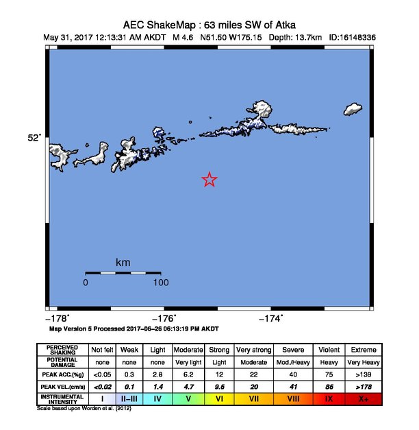
The USGS ShakeMap: shaking estimated from seismic stations and the quake’s size, on the Modified Mercalli intensity scale.
- Strongest estimated
- II, weak shaking
- Map
- Automatic
Did you feel it?
No one has reported feeling this quake to the USGS.
How well it is located
Reviewed by a seismologist.
- Location uncertainty
- About 8.3 km horizontally, 4.5 km in depth
- Magnitude uncertainty
- ±0.03
- Depth from
- From location
- Station coverage gap
- 139°
- Stations used
- 102
Nearby
Within 100 km, magnitude 1.7 and up: 76 in the 60 days after this one and 38 in the 30 days before it.
After
- 2.391 km SW of Atka, Alaska · 3411 days ago · 21 km deep · 30 km away
- 2.888 km E of Adak, Alaska · 3411 days ago · 52 km deep · 16 km away
- 2.092 km SW of Atka, Alaska · 3410 days ago · 18 km deep · 29 km away
- 2.598 km ESE of Adak, Alaska · 3408 days ago · 47 km deep · 32 km away
- 2.380 km ENE of Adak, Alaska · 3408 days ago · 89 km deep · 26 km away
- 2.034 km SSE of Adak, Alaska · 3407 days ago · 36 km deep · 80 km away
- 4.387 km WSW of Atka, Alaska · 3405 days ago · 48 km deep · 14 km away
- 2.028 km SE of Adak, Alaska · 3405 days ago · 56 km deep · 67 km away
- 2.166 km E of Adak, Alaska · 3404 days ago · 62 km deep · 23 km away
- 3.393 km SW of Atka, Alaska · 3404 days ago · 38 km deep · 23 km away
- 3.153 km SW of Atka, Alaska · 3404 days ago · 51 km deep · 45 km away
- 2.556 km WSW of Atka, Alaska · 3404 days ago · 66 km deep · 31 km away
- 2.948 km SE of Adak, Alaska · 3403 days ago · 28 km deep · 70 km away
- 1.920 km ENE of Adak, Alaska · 3402 days ago · 6 km deep · 69 km away
- 1.962 km W of Atka, Alaska · 3402 days ago · 7 km deep · 37 km away
- 1.755 km ESE of Adak, Alaska · 3402 days ago · 44 km deep · 42 km away
- 1.882 km E of Adak, Alaska · 3402 days ago · 21 km deep · 7 km away
- 3.656 km W of Atka, Alaska · 3400 days ago · 81 km deep · 36 km away
- 2.347 km E of Adak, Alaska · 3400 days ago · 70 km deep · 40 km away
- 2.729 km S of Adak, Alaska · 3399 days ago · 46 km deep · 97 km away
- 2.16 km ENE of Adak, Alaska · 3398 days ago · 86 km deep · 81 km away
- 2.2Andreanof Islands, Aleutian Islands, Alaska · 3398 days ago · 42 km deep · 74 km away
- 2.395 km SW of Atka, Alaska · 3396 days ago · 25 km deep · 35 km away
- 2.683 km W of Atka, Alaska · 3396 days ago · 235 km deep · 46 km away
- 1.722 km SSE of Adak, Alaska · 3396 days ago · 58 km deep · 80 km away
- 2.195 km ESE of Adak, Alaska · 3395 days ago · 35 km deep · 39 km away
- 2.695 km WNW of Atka, Alaska · 3393 days ago · 107 km deep · 75 km away
- 1.764 km SSE of Adak, Alaska · 3393 days ago · 41 km deep · 76 km away
- 2.296 km SW of Atka, Alaska · 3392 days ago · 31 km deep · 32 km away
- 1.9106 km SSW of Atka, Alaska · 3391 days ago · 26 km deep · 92 km away
- 1.886 km ESE of Adak, Alaska · 3390 days ago · 40 km deep · 21 km away
- 2.050 km SE of Adak, Alaska · 3389 days ago · 26 km deep · 73 km away
- 2.636 km NE of Adak, Alaska · 3388 days ago · 137 km deep · 72 km away
- 4.057 km NW of Atka, Alaska · 3387 days ago · 228 km deep · 77 km away
- 2.166 km SSE of Adak, Alaska · 3387 days ago · 16 km deep · 95 km away
- 1.787 km SW of Atka, Alaska · 3386 days ago · 26 km deep · 26 km away
- 1.951 km SE of Adak, Alaska · 3385 days ago · 41 km deep · 70 km away
- 1.867 km E of Adak, Alaska · 3382 days ago · 25 km deep · 23 km away
- 2.547 km SSE of Adak, Alaska · 3382 days ago · 35 km deep · 80 km away
- 2.997 km SSW of Atka, Alaska · 3382 days ago · 19 km deep · 85 km away
- 1.850 km SSE of Adak, Alaska · 3381 days ago · 26 km deep · 86 km away
- 2.357 km SSE of Adak, Alaska · 3379 days ago · 26 km deep · 83 km away
- 2.510 km WNW of Atka, Alaska · 3379 days ago · 178 km deep · 79 km away
- 1.853 km SE of Adak, Alaska · 3378 days ago · 26 km deep · 69 km away
- 2.5104 km SSW of Atka, Alaska · 3377 days ago · 23 km deep · 85 km away
- 2.091 km SW of Atka, Alaska · 3376 days ago · 47 km deep · 19 km away
- 2.431 km SSW of Atka, Alaska · 3375 days ago · 56 km deep · 65 km away
- 2.459 km SE of Adak, Alaska · 3375 days ago · 24 km deep · 73 km away
- 1.962 km SSE of Adak, Alaska · 3375 days ago · 19 km deep · 78 km away
- 2.069 km SW of Atka, Alaska · 3373 days ago · 26 km deep · 38 km away
- 1.948 km SE of Adak, Alaska · 3373 days ago · 24 km deep · 73 km away
- 3.723 km NW of Atka, Alaska · 3370 days ago · 191 km deep · 86 km away
- 3.764 km NE of Adak, Alaska · 3370 days ago · 172 km deep · 69 km away
- 2.5118 km SSW of Atka, Alaska · 3369 days ago · 12 km deep · 74 km away
- 2.073 km SW of Atka, Alaska · 3368 days ago · 26 km deep · 35 km away
- 3.254 km ESE of Adak, Alaska · 3368 days ago · 47 km deep · 45 km away
- 1.861 km SSE of Adak, Alaska · 3368 days ago · 29 km deep · 97 km away
- 2.460 km SE of Adak, Alaska · 3366 days ago · 19 km deep · 74 km away
- 1.735 km SSW of Atka, Alaska · 3366 days ago · 48 km deep · 67 km away
- 1.7Andreanof Islands, Aleutian Islands, Alaska · 3365 days ago · 47 km deep · 53 km away
The first 60 of 76.
Before
- 2.363 km SE of Adak, Alaska · 3411 days ago · 23 km deep · 51 km away
- 1.74 km NE of Adak, Alaska · 3412 days ago · 70 km deep · 83 km away
- 1.935 km ESE of Adak, Alaska · 3412 days ago · 64 km deep · 55 km away
- 3.389 km SW of Atka, Alaska · 3413 days ago · 48 km deep · 19 km away
- 2.487 km SW of Atka, Alaska · 3413 days ago · 26 km deep · 18 km away
- 2.724 km SSE of Adak, Alaska · 3414 days ago · 52 km deep · 83 km away
- 2.588 km SW of Atka, Alaska · 3414 days ago · 25 km deep · 19 km away
- 4.789 km E of Adak, Alaska · 3414 days ago · 35 km deep · 13 km away
- 3.092 km SW of Atka, Alaska · 3414 days ago · 26 km deep · 29 km away
- 5.388 km WSW of Atka, Alaska · 3414 days ago · 34 km deep · 15 km away · tsunami flag
- 2.153 km S of Adak, Alaska · 3415 days ago · 26 km deep · 96 km away
- 2.262 km SE of Adak, Alaska · 3417 days ago · 24 km deep · 60 km away
- 2.9Andreanof Islands, Aleutian Islands, Alaska · 3417 days ago · 5 km deep · 90 km away
- 2.539 km S of Adak, Alaska · 3418 days ago · 47 km deep · 95 km away
- 2.629 km NNW of Atka, Alaska · 3419 days ago · 166 km deep · 93 km away
- 4.025 km SSE of Adak, Alaska · 3422 days ago · 52 km deep · 83 km away
- 2.1115 km SSW of Atka, Alaska · 3422 days ago · 13 km deep · 71 km away
- 2.378 km SSW of Atka, Alaska · 3422 days ago · 4 km deep · 64 km away
- 2.439 km SSE of Adak, Alaska · 3423 days ago · 32 km deep · 81 km away
- 2.637 km N of Adak, Alaska · 3423 days ago · 170 km deep · 97 km away
Earthquakes todayAlaska earthquakesLive radar here
Sources
From the USGS Earthquake Hazards Program and its partner networks, event us10008wt8 (also filed as ak16148336, ak0176xuzq69). Read Fri, Oct 2, 2026, 2:01 PM UTC.