M6.9 earthquake 76 km SE of Mawlaik, Myanmar
A magnitude 6.9 earthquake struck 76 km SE of Mawlaik, Myanmar on Wed, Apr 13, 2016, 8:25 PM GMT+6:30 (13:55 UTC), 136 km (85 mi) below the surface.
Map
Where this earthquake was located, with the others nearby. Select one for its page.
The earthquake
- Magnitude
- 6.9 (Mww, W-phase moment), strong
- Magnitude from
- USGS National Earthquake Information Center
- Local time
- UTC
- 2016-04-13 13:55:17 UTC
- Depth
- 136.0 km (84.5 mi), intermediate-depth
- Epicenter
- 23.094° N, 94.865° E
- Region
- Myanmar
- Felt reports
- 289
- Strongest shaking
- VI, strong shaking
- PAGER alert
- Yellow
- Tsunami flag
- No
- Status
- Reviewed by a seismologist
Magnitude estimates
Different scales measure different things and differ by a few tenths. The USGS marks one as preferred, and it is the one this page uses.
| Mag. | Scale | Computed by | Notes |
|---|---|---|---|
| 6.9 | Mww, W-phase moment | USGS National Earthquake Information Center | Preferred · Reviewed |
| 6.93 | Mw, moment | ISC-GEM global catalog | Final · ±0.1 |
| 6.9 | Mwc, centroid moment | USGS National Earthquake Information Center | Moment tensor · Reviewed |
| 6.9 | Mwb, body-wave moment | USGS National Earthquake Information Center | Moment tensor · Reviewed |
Deaths and damage
From NOAA NCEI’s Significant Earthquake Database (record 10363), matched to this event by time and place.
- Deaths
- 2
- Injuries
- 170
- Damage
- Moderate (about $1 to $5 million)
- Houses damaged
- 4
Where the literature gives no number, NCEI records a description on a scale of 1 to 4, printed here in its words. Damage is in millions of US dollars of the year of the event, not adjusted for inflation.
From Wikipedia
A magnitude 6.9 earthquake struck Myanmar 135 km (84 mi) north-west of Mandalay on April 13 with a maximum Mercalli intensity of VI (Strong). It struck at 8:25 pm local time (13:55 UTC), and was centered in an isolated area. The estimated depth was 134 km. It lasted for around one minute according to Xinhua reporters.
Text from Wikipedia, “2016 Kani earthquake”, licensed CC BY-SA 4.0. Quoted as written; the full article has the rest.
The article is about the earthquake NOAA’s record describes, matched to this one by date, place and magnitude.
Wikidata records: 2 deaths and 120 injured. These are counts entered by Wikidata’s editors; they may differ from the official count, and this page never adds them to another figure. Q23809830, CC0.
What happened
The USGS’s account of the effects of this earthquake.
At least 2 people killed, 70 injured and power outages occurred in Assam, India. Felt (V) at Agartala, Bara Bazar and Chakdaha; (IV) at Bankra, Guwahati, Kolkata, Salt Lake City and Shiliguri. Felt in Assam, Bihar, Jharkhand, Manipur, Meghalaya, Mizoram, Nagaland, Odisha, Sikkim, Tripura, Uttar Pradesh, West Bengal and as far as Delhi. At least 50 people injured and 4 buildings damaged in the Chittagong area, and about 50 people were injured fleeing buildings at Dhaka and Sylhet, Bangladesh. Felt (VI) at Sylhet, (V) at Chittagong and (IV) at Barisal, Dhaka and Tungi. Felt (III) at Rangoon, Burma, at Thimphu, Bhutan and at Kathmandu, Nepal. Felt in other parts of Bangladesh, Bhutan, Burma and Nepal. Also felt at Dali, China.
From the USGS event page for us20005hqz. U.S. Geological Survey text and figures are in the public domain.
Shaking
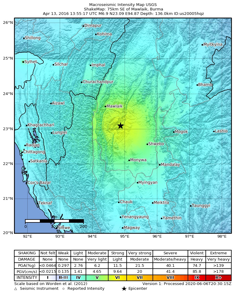
The USGS ShakeMap: shaking estimated from seismic stations and the quake’s size, on the Modified Mercalli intensity scale.
- Strongest estimated
- VI, strong shaking
- Peak ground acceleration
- 10.0% of gravity
- Peak ground velocity
- 2.0 cm/s
- Map
- Automatic
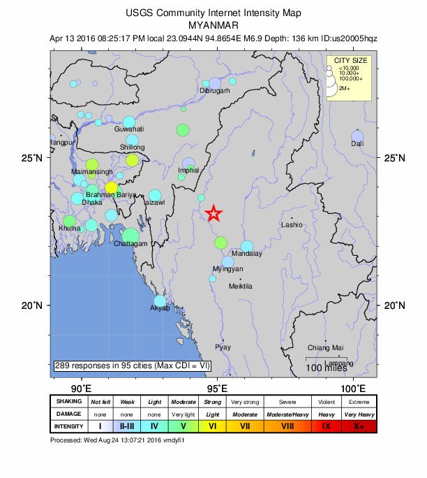
Did you feel it?
289 people reported to the USGS what they felt; the strongest reported shaking was VI, strong shaking.
Estimated impact
The USGS PAGER system estimates deaths and economic losses from the shaking and the population and buildings exposed to it.
- Alert level
- Yellow: some damage and deaths possible, a local or regional response
Fault motion and ground failure
How the rock slipped, from the moment tensor, and the USGS estimate of landslides and liquefaction.
- Faulting
- Reverse (thrust)
- Moment magnitude
- 6.9 Mww
- Nodal plane 1
- Strike 265°, dip 61°, rake 66°
- Nodal plane 2
- Strike 127°, dip 37°, rake 126°
Tectonic setting
Why earthquakes happen here, from the USGS tectonic summary.
The April 13, 2016 M 6.9 earthquake southeast of Mawlaik, Burma, occurred as the result of oblique reverse faulting at an intermediate depth, approximately 140 km beneath western Burma. The epicenter of the earthquake is located some 500 km to the northeast of the Sunda Trench, where lithosphere of the India plate begins subducting to the northeast beneath Sunda and Eurasia. Focal mechanisms indicate rupture occurred on either a west-striking fault dipping steeply to the north, or on a southeast striking structure dipping moderately to the southwest. The location, depth and faulting parameters all indicate this earthquake occurred within the lithosphere of the subducting India plate. At the location of this earthquake, the India plate moves north-northeast with respect to the Sunda and Eurasia plates, at a velocity of 44-49 mm/yr. Regionally, the subducted India plate is seismically active to a depth of about 150 km.
Earthquakes like this event, with focal depths between 70 and 300 km, are commonly termed "intermediate-depth" earthquakes. Intermediate-depth earthquakes represent deformation within subducted slabs rather than at the shallow plate interface between subducting and overriding tectonic plates. They typically cause less severe shaking on the ground surface directly above their foci than is the case with similar magnitude shallow-focus earthquakes, but large intermediate-depth earthquakes beneath populated regions may nonetheless cause damage and casualties, and they may be felt at great distance from their epicenters.
The Burma region experiences earthquakes somewhat regularly, and 38 other events of M 6 or larger have occurred within 400 km of the April 13, 2016 event over the preceding century. Eleven of these occurred at intermediate depths. The largest nearby earthquake was a M 8.0 event in September 1946, 130 km to the northeast of the April 2016 earthquake, whose epicenter has been calculated to be within the earth's crust. Little is known about the effects of that earthquake. At intermediate depths, the largest nearby event over the preceding century was a M 7.3 earthquake in August 1988 in northern Burma, 200 km to the north of the April 2016 event. The 1988 earthquake caused several fatalities and dozens more injuries.
From the USGS event page for us20005hqz. U.S. Geological Survey text and figures are in the public domain.
How well it is located
Reviewed by a seismologist.
- Location uncertainty
- About 7.1 km horizontally, 1.8 km in depth
- Depth from
- From modeling of broad-band P waveforms
- Station coverage gap
- 14°
- Stations used
- 334
Nearest places
Distance and direction from each place to the epicenter, with its forecast.
Nearby
Within 100 km, magnitude 3.9 and up: 4 in the 60 days after this one and 1 in the 30 days before it.
After
- 4.271 km NW of Monywa, Myanmar · 3806 days ago · 79 km deep · 55 km away
- 4.249 km WNW of Monywa, Myanmar · 3805 days ago · 120 km deep · 93 km away
- 4.127 km SSW of Mawlaik, Myanmar · 3801 days ago · 27 km deep · 70 km away
- 4.034 km NNE of Mawlaik, Myanmar · 3785 days ago · 84 km deep · 95 km away
Before
Earthquakes todayMyanmar earthquakesLive radar here
Sources
From the USGS Earthquake Hazards Program and its partner networks, event us20005hqz (also filed as gcmt20160413135517, iscgem611829306, atlas20160413135517). Read Fri, Oct 2, 2026, 7:12 AM UTC.