M2.0 earthquake 3 km E of Luther, Oklahoma
A magnitude 2.0 earthquake struck 3 km E of Luther, Oklahoma on Tue, Jul 12, 2016, 11:51 PM CDT (04:51 UTC), 3 km (2 mi) below the surface.
A larger quake followed: M5.8 14 km NW of Pawnee, Oklahoma. This one was a foreshock.
Map
Where this earthquake was located, with the others nearby. Select one for its page.
The earthquake
- Magnitude
- 2.0 (ML, local (Richter)), micro
- Magnitude from
- USGS National Earthquake Information Center
- Local time
- UTC
- 2016-07-13 04:51:45 UTC
- Depth
- 3.2 km (2.0 mi), shallow
- Epicenter
- 35.656° N, 97.153° W
- Region
- Oklahoma
- Felt reports
- 1
- Tsunami flag
- No
- Status
- Reviewed by a seismologist
What happened
The USGS’s account of the effects of this earthquake.
Felt at Luther.
From the USGS event page for us1000636i. U.S. Geological Survey text and figures are in the public domain.
Did you feel it?
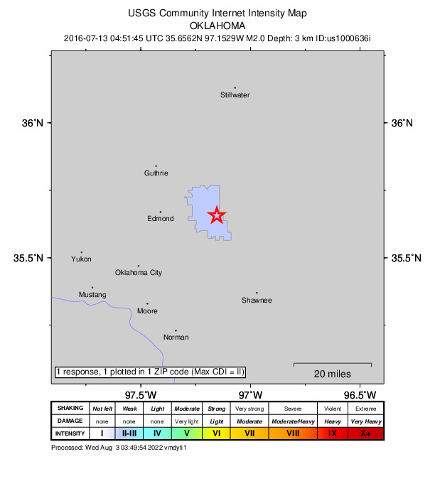
1 person reported to the USGS what they felt; the strongest reported shaking was II, weak shaking.
How well it is located
Reviewed by a seismologist.
- Location uncertainty
- About 1.2 km horizontally, 1.1 km in depth
- Magnitude uncertainty
- ±0.06
- Depth from
- From location
- Station coverage gap
- 49°
- Stations used
- 50
Nearest places
Distance and direction from each place to the epicenter, with its forecast.
Nearby
Within 100 km, magnitude 1.5 and up: at least 199 in the 60 days after this one and 91 in the 30 days before it.
After
- 3.43 km WSW of Nicoma Park, Oklahoma · 3735 days ago · 7 km deep · 27 km away · felt by 11
- 2.70 km NNE of Coyle, Oklahoma · 3734 days ago · 5 km deep · 34 km away
- 3.03 km ESE of Fairmont, Oklahoma · 3734 days ago · 6 km deep · 89 km away
- 2.84 km S of Meridian, Oklahoma · 3734 days ago · 7 km deep · 18 km away
- 2.64 km SSE of Covington, Oklahoma · 3734 days ago · 5 km deep · 78 km away
- 3.17 km ENE of Guthrie, Oklahoma · 3733 days ago · 5 km deep · 34 km away
- 2.64 km SSE of Covington, Oklahoma · 3732 days ago · 3 km deep · 78 km away
- 2.60 km NNW of Stillwater, Oklahoma · 3732 days ago · 6 km deep · 53 km away · felt by 1
- 4.25 km W of Lucien, Oklahoma · 3732 days ago · 5 km deep · 77 km away · felt by 970
- 3.55 km WNW of Lucien, Oklahoma · 3732 days ago · 6 km deep · 77 km away · felt by 1
- 2.55 km WNW of Lucien, Oklahoma · 3732 days ago · 6 km deep · 77 km away
- 2.85 km ESE of Covington, Oklahoma · 3732 days ago · 7 km deep · 78 km away
- 3.14 km WNW of Lucien, Oklahoma · 3732 days ago · 6 km deep · 77 km away · felt by 6
- 2.76 km WNW of Maramec, Oklahoma · 3731 days ago · 5 km deep · 76 km away
- 2.75 km W of Lucien, Oklahoma · 3731 days ago · 5 km deep · 77 km away · felt by 1
- 2.57 km WNW of Maramec, Oklahoma · 3731 days ago · 5 km deep · 76 km away
- 2.34 km E of Perry, Oklahoma · 3731 days ago · 5 km deep · 70 km away · felt by 3
- 2.69 km WNW of Red Rock, Oklahoma · 3731 days ago · 8 km deep · 95 km away
- 2.54 km SSE of Covington, Oklahoma · 3731 days ago · 5 km deep · 78 km away
- 3.210 km NE of Crescent, Oklahoma · 3730 days ago · 6 km deep · 52 km away
- 2.58 km SW of Perry, Oklahoma · 3730 days ago · 5 km deep · 66 km away
- 2.54 km NW of Orlando, Oklahoma · 3730 days ago · 8 km deep · 62 km away
- 3.2Oklahoma · 3729 days ago · 5 km deep · 77 km away
- 2.60 km ENE of Cimarron City, Oklahoma · 3729 days ago · 6 km deep · 47 km away · felt by 1
- 2.56 km ENE of Edmond, Oklahoma · 3729 days ago · 6 km deep · 23 km away · felt by 9
- 2.99 km E of Mulhall, Oklahoma · 3728 days ago · 5 km deep · 47 km away · felt by 2
- 2.53 km WNW of Stillwater, Oklahoma · 3728 days ago · 6 km deep · 53 km away · felt by 3
- 3.69 km NW of Morrison, Oklahoma · 3727 days ago · 10 km deep · 78 km away · felt by 3
- 2.48 km S of Perry, Oklahoma · 3727 days ago · 3 km deep · 63 km away
- 2.67 km NNE of Guthrie, Oklahoma · 3727 days ago · 6 km deep · 39 km away
- 2.66 km W of Arcadia, Oklahoma · 3727 days ago · 7 km deep · 22 km away · felt by 2
- 2.55 km W of Lucien, Oklahoma · 3726 days ago · 6 km deep · 77 km away
- 2.56 km W of Arcadia, Oklahoma · 3726 days ago · 7 km deep · 22 km away · felt by 3
- 3.03 km WNW of Stillwater, Oklahoma · 3725 days ago · 6 km deep · 53 km away · felt by 3
- 2.6Oklahoma · 3725 days ago · 6 km deep · 53 km away · felt by 1
- 2.54 km WNW of Stillwater, Oklahoma · 3725 days ago · 3 km deep · 53 km away
- 2.01 km NE of Cushing, Oklahoma · 3724 days ago · 5 km deep · 52 km away · felt by 1
- 2.65 km WNW of Lucien, Oklahoma · 3724 days ago · 6 km deep · 77 km away
- 2.63 km E of Luther, Oklahoma · 3723 days ago · 5 km deep · 0 km away · felt by 3
- 2.72 km W of Kendrick, Oklahoma · 3723 days ago · 6 km deep · 35 km away
- 2.53 km WNW of Stillwater, Oklahoma · 3722 days ago · 7 km deep · 53 km away · felt by 1
- 2.61 km NE of Meridian, Oklahoma · 3721 days ago · 5 km deep · 23 km away
- 2.71 km NE of Meridian, Oklahoma · 3721 days ago · 5 km deep · 23 km away
- 3.68 km NNE of Marshall, Oklahoma · 3720 days ago · 5 km deep · 73 km away · felt by 30
- 2.813 km NNW of Pawnee, Oklahoma · 3720 days ago · 8 km deep · 91 km away
- 2.6Oklahoma · 3720 days ago · 6 km deep · 73 km away
- 2.85 km ESE of Douglas, Oklahoma · 3719 days ago · 3 km deep · 77 km away · felt by 1
- 2.59 km W of Quay, Oklahoma · 3718 days ago · 5 km deep · 65 km away
- 3.13 km S of Cole, Oklahoma · 3717 days ago · 6 km deep · 75 km away · felt by 19
- 2.58 km W of Orlando, Oklahoma · 3717 days ago · 9 km deep · 62 km away
- 2.75 km NW of Orlando, Oklahoma · 3715 days ago · 6 km deep · 64 km away
- 2.37 km SSW of Guthrie, Oklahoma · 3715 days ago · 2 km deep · 32 km away
- 2.43 km ESE of Covington, Oklahoma · 3713 days ago · 5 km deep · 80 km away
- 2.55 km W of Lucien, Oklahoma · 3712 days ago · 6 km deep · 76 km away
- 2.84 km W of Lucien, Oklahoma · 3712 days ago · 5 km deep · 76 km away
- 2.98 km NE of Marshall, Oklahoma · 3712 days ago · 7 km deep · 73 km away
- 2.88 km NE of Marshall, Oklahoma · 3712 days ago · 6 km deep · 73 km away
- 3.04 km NW of Orlando, Oklahoma · 3711 days ago · 6 km deep · 63 km away · felt by 1
- 2.77 km NE of Lake Aluma, Oklahoma · 3710 days ago · 6 km deep · 23 km away · felt by 10
- 2.48 km NNE of Union City, Oklahoma · 3709 days ago · 6 km deep · 72 km away · felt by 1
The first 60 of at least 199.
Before
- 2.72 km ENE of Meridian, Oklahoma · 3736 days ago · 6 km deep · 23 km away
- 2.77 km W of Meeker, Oklahoma · 3737 days ago · 7 km deep · 24 km away · felt by 2
- 2.83 km NNE of Dibble, Oklahoma · 3737 days ago · 4 km deep · 78 km away · felt by 33
- 2.53 km S of Meridian, Oklahoma · 3737 days ago · 5 km deep · 19 km away
- 2.67 km S of Perry, Oklahoma · 3737 days ago · 4 km deep · 64 km away
- 3.14 km ENE of Coyle, Oklahoma · 3737 days ago · 6 km deep · 36 km away · felt by 2
- 2.510 km NE of Crescent, Oklahoma · 3738 days ago · 6 km deep · 52 km away
- 2.73 km NE of Dibble, Oklahoma · 3738 days ago · 4 km deep · 79 km away · felt by 3
- 2.59 km SW of Stillwater, Oklahoma · 3739 days ago · 5 km deep · 43 km away
- 2.43 km NE of Dibble, Oklahoma · 3739 days ago · 5 km deep · 78 km away · felt by 1
- 3.14 km S of Meridian, Oklahoma · 3739 days ago · 7 km deep · 18 km away · felt by 1
- 2.93 km NE of Coyle, Oklahoma · 3739 days ago · 6 km deep · 36 km away
- 3.63 km NE of Coyle, Oklahoma · 3739 days ago · 5 km deep · 36 km away · felt by 8
- 2.610 km NE of Crescent, Oklahoma · 3740 days ago · 6 km deep · 52 km away · felt by 5
- 3.06 km ENE of Covington, Oklahoma · 3740 days ago · 7 km deep · 81 km away · felt by 1
- 2.63 km E of Luther, Oklahoma · 3740 days ago · 5 km deep · 1 km away
- 3.43 km NE of Dibble, Oklahoma · 3740 days ago · 6 km deep · 78 km away · felt by 8
- 2.54 km NE of Coyle, Oklahoma · 3741 days ago · 5 km deep · 36 km away
- 2.53 km E of Luther, Oklahoma · 3741 days ago · 5 km deep · 0 km away
- 2.84 km E of Luther, Oklahoma · 3741 days ago · 5 km deep · 0 km away
Earthquakes todayOklahoma earthquakesLive radar here
Sources
From the USGS Earthquake Hazards Program and its partner networks, event us1000636i. Read Mon, Oct 5, 2026, 2:53 AM UTC.