M3.5 earthquake 32 km ESE of Lowell Point, Alaska
A magnitude 3.5 earthquake struck 32 km ESE of Lowell Point, Alaska on Tue, Oct 18, 2016, 4:16 PM AKDT (00:16 UTC), 11 km (7 mi) below the surface.
Map
Where this earthquake was located, with the others nearby. Select one for its page.
The earthquake
- Magnitude
- 3.5 (ML, local (Richter)), minor
- Magnitude from
- Alaska Earthquake Center
- Local time
- UTC
- 2016-10-19 00:16:30 UTC
- Depth
- 11.0 km (6.8 mi), shallow
- Epicenter
- 59.949° N, 148.919° W
- Region
- Alaska
- Felt reports
- 5
- Tsunami flag
- No
- Status
- Reviewed by a seismologist
Magnitude estimates
Different scales measure different things and differ by a few tenths. The USGS marks one as preferred, and it is the one this page uses.
| Mag. | Scale | Computed by | Notes |
|---|---|---|---|
| 3.5 | ML, local (Richter) | Alaska Earthquake Center | Preferred · Preliminary |
| 3.5 | ML, local (Richter) | USGS National Earthquake Information Center | Reviewed |
What happened
The USGS’s account of the effects of this earthquake.
Felt (III) at Seward.
From the USGS event page for ak016dgkk6il. U.S. Geological Survey text and figures are in the public domain.
Did you feel it?
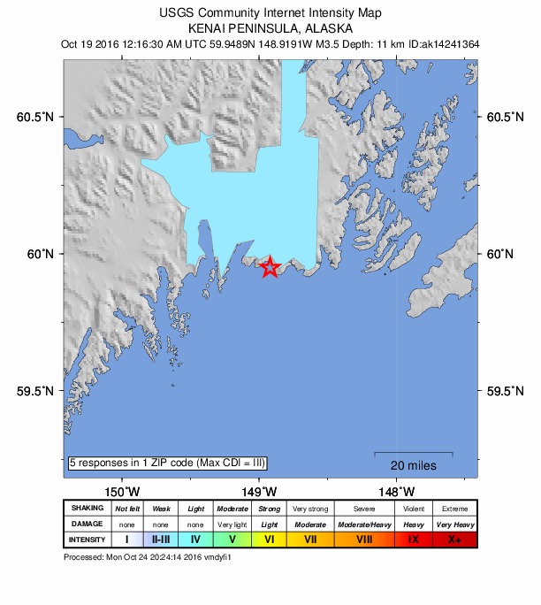
5 people reported to the USGS what they felt; the strongest reported shaking was IV, light shaking.
How well it is located
Reviewed by a seismologist.
- Stations used
- 165
Nearest places
Distance and direction from each place to the epicenter, with its forecast.
Nearby
Within 100 km, magnitude 1.5 and up: 54 in the 60 days after this one and 12 in the 30 days before it.
After
- 1.99 km W of Seward, Alaska · 3638 days ago · 36 km deep · 42 km away
- 1.718 km WSW of Cooper Landing, Alaska · 3636 days ago · 36 km deep · 85 km away
- 1.634 km NE of Fox River, Alaska · 3634 days ago · 43 km deep · 86 km away
- 2.320 km SE of Lowell Point, Alaska · 3634 days ago · 1 km deep · 14 km away
- 1.822 km E of Moose Pass, Alaska · 3631 days ago · 18 km deep · 61 km away
- 1.543 km NNE of Chenega, Alaska · 3631 days ago · 4 km deep · 82 km away
- 1.69 km E of Lowell Point, Alaska · 3630 days ago · 10 km deep · 23 km away
- 1.623 km SE of Whittier, Alaska · 3629 days ago · 8 km deep · 83 km away
- 1.535 km SE of Fox River, Alaska · 3629 days ago · 30 km deep · 94 km away
- 2.116 km NNW of Cooper Landing, Alaska · 3628 days ago · 37 km deep · 93 km away
- 1.523 km SSW of Whittier, Alaska · 3627 days ago · 11 km deep · 72 km away
- 2.217 km NNW of Moose Pass, Alaska · 3624 days ago · 10 km deep · 82 km away
- 1.539 km NNE of Chenega, Alaska · 3624 days ago · 13 km deep · 83 km away
- 1.631 km NE of Fox River, Alaska · 3622 days ago · 39 km deep · 90 km away
- 2.211 km S of Sunrise, Alaska · 3620 days ago · 35 km deep · 97 km away
- 2.433 km ENE of Fox River, Alaska · 3620 days ago · 11 km deep · 81 km away
- 2.047 km SE of Lowell Point, Alaska · 3619 days ago · 11 km deep · 25 km away
- 1.616 km N of Moose Pass, Alaska · 3616 days ago · 12 km deep · 81 km away
- 2.821 km SE of Sunrise, Alaska · 3615 days ago · 27 km deep · 88 km away · felt by 1
- 1.629 km SE of Fox River, Alaska · 3615 days ago · 11 km deep · 100 km away
- 1.747 km ESE of Whittier, Alaska · 3614 days ago · 8 km deep · 90 km away
- 1.645 km NNE of Chenega, Alaska · 3614 days ago · 7 km deep · 86 km away
- 2.014 km SE of Chenega, Alaska · 3613 days ago · 25 km deep · 59 km away
- 1.732 km SE of Fox River, Alaska · 3611 days ago · 38 km deep · 92 km away
- 1.75 km NE of Whittier, Alaska · 3611 days ago · 30 km deep · 97 km away
- 1.841 km NNE of Chenega, Alaska · 3610 days ago · 3 km deep · 83 km away
- 1.736 km NNE of Chenega, Alaska · 3610 days ago · 11 km deep · 80 km away
- 2.139 km NNE of Chenega, Alaska · 3609 days ago · 4 km deep · 81 km away
- 2.237 km E of Chenega, Alaska · 3609 days ago · 5 km deep · 89 km away
- 1.639 km SE of Whittier, Alaska · 3608 days ago · 14 km deep · 74 km away
- 1.643 km NNE of Chenega, Alaska · 3608 days ago · 15 km deep · 84 km away
- 1.531 km NNW of Chenega, Alaska · 3606 days ago · 2 km deep · 60 km away
- 1.637 km ESE of Fox River, Alaska · 3605 days ago · 6 km deep · 81 km away
- 1.742 km E of Primrose, Alaska · 3603 days ago · 15 km deep · 49 km away
- 1.520 km SE of Lowell Point, Alaska · 3602 days ago · 13 km deep · 14 km away
- 1.721 km SSE of Lowell Point, Alaska · 3601 days ago · 8 km deep · 21 km away
- 1.651 km N of Chenega, Alaska · 3600 days ago · 15 km deep · 88 km away
- 3.038 km NNW of Chenega, Alaska · 3599 days ago · 24 km deep · 59 km away
- 1.835 km ESE of Chenega, Alaska · 3599 days ago · 15 km deep · 83 km away
- 2.420 km SSW of Whittier, Alaska · 3598 days ago · 14 km deep · 74 km away
- 2.637 km SE of Funny River, Alaska · 3596 days ago · 56 km deep · 85 km away
- 1.538 km SSE of Whittier, Alaska · 3595 days ago · 4 km deep · 65 km away
- 1.718 km SE of Lowell Point, Alaska · 3591 days ago · 15 km deep · 15 km away
- 2.118 km W of Whittier, Alaska · 3591 days ago · 25 km deep · 91 km away
- 1.615 km E of Whittier, Alaska · 3590 days ago · 19 km deep · 98 km away
- 1.526 km ESE of Fox River, Alaska · 3589 days ago · 26 km deep · 93 km away
- 1.734 km SSE of Funny River, Alaska · 3588 days ago · 48 km deep · 95 km away
- 1.836 km ESE of Lowell Point, Alaska · 3588 days ago · 10 km deep · 5 km away
- 1.6Southern Alaska · 3587 days ago · 8 km deep · 85 km away
- 1.646 km NNE of Chenega, Alaska · 3586 days ago · 9 km deep · 87 km away
- 1.626 km NNE of Chenega, Alaska · 3584 days ago · 10 km deep · 70 km away
- 1.742 km NNE of Chenega, Alaska · 3584 days ago · 7 km deep · 84 km away
- 1.642 km NNE of Chenega, Alaska · 3581 days ago · 4 km deep · 81 km away
- 1.744 km NNE of Chenega, Alaska · 3579 days ago · 4 km deep · 85 km away
Before
- 1.646 km NNE of Chenega, Alaska · 3639 days ago · 3 km deep · 88 km away
- 1.66 km WNW of Cooper Landing, Alaska · 3640 days ago · 43 km deep · 84 km away
- 1.59 km ENE of Chenega, Alaska · 3640 days ago · 9 km deep · 61 km away
- 1.616 km SW of Chenega, Alaska · 3642 days ago · 4 km deep · 41 km away
- 1.624 km SW of Lowell Point, Alaska · 3643 days ago · 6 km deep · 45 km away
- 1.5Kenai Peninsula, Alaska · 3652 days ago · 40 km deep · 95 km away
- 1.8Southern Alaska · 3654 days ago · 3 km deep · 87 km away
- 2.838 km NE of Fox River, Alaska · 3658 days ago · 37 km deep · 88 km away
- 1.645 km NNE of Chenega, Alaska · 3664 days ago · 8 km deep · 83 km away
- 1.848 km ESE of Whittier, Alaska · 3665 days ago · 3 km deep · 91 km away
- 1.815 km WSW of Chenega, Alaska · 3665 days ago · 16 km deep · 37 km away
- 1.929 km ESE of Lowell Point, Alaska · 3665 days ago · 14 km deep · 3 km away
Earthquakes todayAlaska earthquakesLive radar here
Sources
From the USGS Earthquake Hazards Program and its partner networks, event ak016dgkk6il (also filed as ak14241364, us20007f7i). Read Mon, Oct 5, 2026, 7:12 AM UTC.