M2.9 earthquake 17 km S of Kokhanok, Alaska
A magnitude 2.9 earthquake struck 17 km S of Kokhanok, Alaska on Tue, Nov 29, 2016, 11:49 AM AKST (20:49 UTC), 2 km (1 mi) below the surface.
A larger quake followed: M3.7 48 km ESE of Pedro Bay, Alaska. This one was a foreshock.
Map
Where this earthquake was located, with the others nearby. Select one for its page.
The earthquake
- Magnitude
- 2.9 (ML, local (Richter)), micro
- Magnitude from
- Alaska Earthquake Center
- Local time
- UTC
- 2016-11-29 20:49:30 UTC
- Depth
- 2.4 km (1.5 mi), shallow
- Epicenter
- 59.283° N, 154.800° W
- Region
- Alaska
- Felt reports
- 1
- Tsunami flag
- No
- Status
- Reviewed by a seismologist
Magnitude estimates
Different scales measure different things and differ by a few tenths. The USGS marks one as preferred, and it is the one this page uses.
| Mag. | Scale | Computed by | Notes |
|---|---|---|---|
| 2.9 | ML, local (Richter) | Alaska Earthquake Center | Preferred · Preliminary |
| 2.9 | ML, local (Richter) | USGS National Earthquake Information Center | Reviewed |
What happened
The USGS’s account of the effects of this earthquake.
Felt at Levelock.
From the USGS event page for ak016fcpp5h8. U.S. Geological Survey text and figures are in the public domain.
Did you feel it?
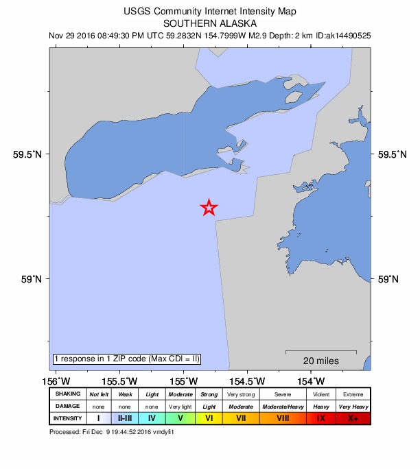
1 person reported to the USGS what they felt; the strongest reported shaking was II, weak shaking.
How well it is located
Reviewed by a seismologist.
- Stations used
- 55
Nearest places
Distance and direction from each place to the epicenter, with its forecast.
Nearby
Within 100 km, magnitude 1.5 and up: 131 in the 60 days after this one and 76 in the 30 days before it.
After
- 2.581 km S of Kokhanok, Alaska · 3595 days ago · 123 km deep · 64 km away
- 2.645 km ESE of Pedro Bay, Alaska · 3594 days ago · 110 km deep · 93 km away
- 2.038 km ESE of Pedro Bay, Alaska · 3594 days ago · 118 km deep · 87 km away
- 2.158 km ESE of Pope-Vannoy Landing, Alaska · 3591 days ago · 106 km deep · 67 km away
- 2.561 km SSE of Kokhanok, Alaska · 3591 days ago · 123 km deep · 47 km away · felt by 1
- 1.791 km WNW of Aleneva, Alaska · 3590 days ago · 91 km deep · 94 km away
- 1.647 km ESE of Pedro Bay, Alaska · 3589 days ago · 106 km deep · 95 km away
- 1.969 km ESE of Pope-Vannoy Landing, Alaska · 3587 days ago · 92 km deep · 76 km away
- 1.941 km SE of Pedro Bay, Alaska · 3587 days ago · 100 km deep · 76 km away
- 2.946 km ESE of Pedro Bay, Alaska · 3587 days ago · 107 km deep · 95 km away
- 1.956 km SE of Pedro Bay, Alaska · 3586 days ago · 108 km deep · 76 km away
- 1.743 km ESE of Pedro Bay, Alaska · 3585 days ago · 104 km deep · 92 km away
- 1.767 km SE of Kokhanok, Alaska · 3585 days ago · 20 km deep · 57 km away
- 2.036 km ENE of Pedro Bay, Alaska · 3585 days ago · 133 km deep · 100 km away
- 1.8Alaska Peninsula · 3585 days ago · 108 km deep · 48 km away
- 1.643 km ESE of Pedro Bay, Alaska · 3584 days ago · 115 km deep · 89 km away
- 1.740 km ESE of Pope-Vannoy Landing, Alaska · 3584 days ago · 122 km deep · 57 km away
- 1.763 km SE of Pope-Vannoy Landing, Alaska · 3583 days ago · 99 km deep · 63 km away
- 1.894 km NNW of Karluk, Alaska · 3582 days ago · 5 km deep · 98 km away
- 2.065 km SSE of Kokhanok, Alaska · 3582 days ago · 114 km deep · 50 km away
- 1.967 km SE of Pope-Vannoy Landing, Alaska · 3581 days ago · 90 km deep · 71 km away
- 2.461 km SSE of Kokhanok, Alaska · 3581 days ago · 108 km deep · 48 km away
- 1.694 km NW of Aleneva, Alaska · 3580 days ago · 73 km deep · 82 km away
- 1.670 km SE of Pope-Vannoy Landing, Alaska · 3580 days ago · 93 km deep · 77 km away
- 2.034 km ENE of Pedro Bay, Alaska · 3579 days ago · 123 km deep · 97 km away
- 2.926 km SSE of Pope-Vannoy Landing, Alaska · 3579 days ago · 10 km deep · 31 km away
- 1.760 km ESE of Pedro Bay, Alaska · 3578 days ago · 109 km deep · 94 km away
- 1.834 km ENE of Pedro Bay, Alaska · 3577 days ago · 133 km deep · 98 km away
- 1.567 km SE of Pedro Bay, Alaska · 3577 days ago · 92 km deep · 84 km away
- 1.855 km SE of Pope-Vannoy Landing, Alaska · 3577 days ago · 125 km deep · 60 km away
- 1.694 km SE of Pope-Vannoy Landing, Alaska · 3576 days ago · 14 km deep · 88 km away
- 1.840 km SE of Pedro Bay, Alaska · 3575 days ago · 122 km deep · 73 km away
- 1.795 km NNW of Karluk, Alaska · 3575 days ago · 6 km deep · 97 km away
- 2.446 km ESE of Pedro Bay, Alaska · 3573 days ago · 108 km deep · 93 km away
- 1.958 km ESE of Pedro Bay, Alaska · 3573 days ago · 100 km deep · 94 km away
- 2.885 km S of Kokhanok, Alaska · 3573 days ago · 127 km deep · 68 km away
- 2.265 km SE of Pedro Bay, Alaska · 3573 days ago · 104 km deep · 91 km away
- 1.619 km S of Kokhanok, Alaska · 3572 days ago · 7 km deep · 3 km away
- 1.863 km SE of Pope-Vannoy Landing, Alaska · 3572 days ago · 118 km deep · 69 km away
- 2.973 km SE of Pedro Bay, Alaska · 3569 days ago · 84 km deep · 85 km away · felt by 1
- 2.148 km ESE of Pedro Bay, Alaska · 3569 days ago · 107 km deep · 94 km away
- 1.787 km NNW of Aleneva, Alaska · 3569 days ago · 5 km deep · 89 km away
- 2.093 km NNW of Aleneva, Alaska · 3569 days ago · 11 km deep · 82 km away
- 2.066 km ESE of Pope-Vannoy Landing, Alaska · 3568 days ago · 102 km deep · 75 km away
- 2.240 km E of Pedro Bay, Alaska · 3568 days ago · 123 km deep · 100 km away
- 1.887 km NW of Aleneva, Alaska · 3568 days ago · 97 km deep · 87 km away
- 1.992 km WNW of Aleneva, Alaska · 3568 days ago · 1 km deep · 99 km away
- 1.783 km NW of Aleneva, Alaska · 3567 days ago · 81 km deep · 97 km away
- 1.843 km E of Pedro Bay, Alaska · 3567 days ago · 117 km deep · 97 km away
- 1.593 km SE of Kokhanok, Alaska · 3565 days ago · 9 km deep · 83 km away
- 1.889 km NNW of Aleneva, Alaska · 3565 days ago · 70 km deep · 91 km away
- 1.792 km NNW of Aleneva, Alaska · 3565 days ago · 14 km deep · 87 km away
- 1.791 km SE of Kokhanok, Alaska · 3564 days ago · 5 km deep · 81 km away
- 3.011 km ESE of Kokhanok, Alaska · 3564 days ago · 178 km deep · 20 km away
- 1.684 km SE of Kokhanok, Alaska · 3564 days ago · 1 km deep · 75 km away
- 1.887 km SE of Kokhanok, Alaska · 3564 days ago · 11 km deep · 77 km away
- 2.694 km SE of Kokhanok, Alaska · 3564 days ago · 11 km deep · 84 km away
- 1.691 km SE of Kokhanok, Alaska · 3564 days ago · 5 km deep · 81 km away
- 1.593 km NNW of Aleneva, Alaska · 3563 days ago · 15 km deep · 86 km away
- 1.893 km NNW of Aleneva, Alaska · 3563 days ago · 7 km deep · 87 km away
The first 60 of 131.
Before
- 1.990 km WSW of Nanwalek, Alaska · 3596 days ago · 70 km deep · 96 km away
- 1.687 km SE of Kokhanok, Alaska · 3597 days ago · 4 km deep · 76 km away
- 1.765 km SSE of Kokhanok, Alaska · 3597 days ago · 106 km deep · 49 km away
- 2.235 km ENE of Pedro Bay, Alaska · 3597 days ago · 132 km deep · 98 km away
- 2.261 km S of Kokhanok, Alaska · 3597 days ago · 116 km deep · 44 km away
- 2.172 km E of King Salmon, Alaska · 3599 days ago · 146 km deep · 72 km away
- 2.254 km SSE of Kokhanok, Alaska · 3599 days ago · 123 km deep · 38 km away
- 3.047 km ESE of Pedro Bay, Alaska · 3599 days ago · 106 km deep · 97 km away · felt by 1
- 1.977 km SSE of Kokhanok, Alaska · 3599 days ago · 109 km deep · 61 km away
- 1.882 km NW of Aleneva, Alaska · 3600 days ago · 73 km deep · 93 km away
- 1.828 km E of Pedro Bay, Alaska · 3600 days ago · 119 km deep · 85 km away
- 2.048 km ESE of Pedro Bay, Alaska · 3601 days ago · 106 km deep · 98 km away
- 1.946 km ESE of Pedro Bay, Alaska · 3602 days ago · 106 km deep · 96 km away
- 1.950 km ESE of Pedro Bay, Alaska · 3603 days ago · 113 km deep · 97 km away
- 1.591 km SE of Kokhanok, Alaska · 3605 days ago · 10 km deep · 80 km away
- 2.377 km WSW of Nanwalek, Alaska · 3606 days ago · 76 km deep · 95 km away
- 1.676 km WSW of Nanwalek, Alaska · 3606 days ago · 75 km deep · 96 km away
- 1.690 km NNW of Aleneva, Alaska · 3606 days ago · 1 km deep · 87 km away
- 1.971 km S of Kokhanok, Alaska · 3607 days ago · 130 km deep · 54 km away
- 1.862 km SE of Pope-Vannoy Landing, Alaska · 3608 days ago · 108 km deep · 65 km away
Earthquakes todayAlaska earthquakesLive radar here
Sources
From the USGS Earthquake Hazards Program and its partner networks, event ak016fcpp5h8 (also filed as ak14490525, us10007d5g). Read Sun, Oct 4, 2026, 9:30 AM UTC.