M3.4 earthquake 5 km ENE of Edmond, Oklahoma
A magnitude 3.4 earthquake struck 5 km ENE of Edmond, Oklahoma on Wed, Feb 24, 2016, 5:29 AM CST (11:29 UTC), 6 km (4 mi) below the surface.
A larger quake followed: M4.2 4 km NNE of Crescent, Oklahoma. This one was a foreshock.
Map
Where this earthquake was located, with the others nearby. Select one for its page.
The earthquake
- Magnitude
- 3.4 (ML, local (Richter)), minor
- Magnitude from
- USGS National Earthquake Information Center
- Local time
- UTC
- 2016-02-24 11:29:47 UTC
- Depth
- 6.4 km (4.0 mi), shallow
- Epicenter
- 35.672° N, 97.418° W
- Region
- Oklahoma
- Felt reports
- 28
- Tsunami flag
- No
- Status
- Reviewed by a seismologist
What happened
The USGS’s account of the effects of this earthquake.
Felt (III) at Edmond. Also felt at Arcadia, Marietta, Norman and Oklahoma City.
From the USGS event page for us10004sbr. U.S. Geological Survey text and figures are in the public domain.
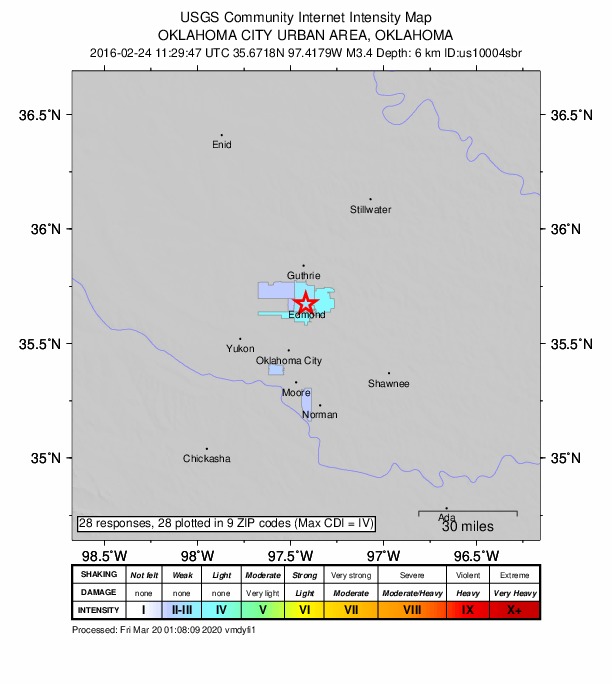
Did you feel it?
28 people reported to the USGS what they felt; the strongest reported shaking was IV, light shaking.
How well it is located
Reviewed by a seismologist.
- Location uncertainty
- About 1.4 km horizontally, 3.9 km in depth
- Station coverage gap
- 35°
- Stations used
- 0
Nearest places
Distance and direction from each place to the epicenter, with its forecast.
Nearby
Within 100 km, magnitude 1.5 and up: 168 in the 60 days after this one and 123 in the 30 days before it.
After
- 2.710 km SSE of Cushing, Oklahoma · 3872 days ago · 5 km deep · 66 km away · felt by 1
- 2.711 km ENE of Orlando, Oklahoma · 3872 days ago · 8 km deep · 58 km away
- 2.13 km WNW of Arcadia, Oklahoma · 3871 days ago · 3 km deep · 5 km away · felt by 3
- 3.012 km SE of Cedar Valley, Oklahoma · 3871 days ago · 7 km deep · 13 km away · felt by 10
- 2.412 km SE of Cedar Valley, Oklahoma · 3871 days ago · 8 km deep · 13 km away
- 3.66 km NW of Meridian, Oklahoma · 3871 days ago · 8 km deep · 25 km away · felt by 95
- 2.66 km NW of Meridian, Oklahoma · 3871 days ago · 6 km deep · 25 km away
- 2.64 km WSW of Luther, Oklahoma · 3871 days ago · 6 km deep · 16 km away · felt by 1
- 3.36 km ENE of Edmond, Oklahoma · 3870 days ago · 7 km deep · 0 km away · felt by 41
- 2.65 km NNE of Dale, Oklahoma · 3870 days ago · 7 km deep · 45 km away
- 2.53 km ESE of Fairmont, Oklahoma · 3870 days ago · 4 km deep · 78 km away · felt by 1
- 3.85 km WNW of Lucien, Oklahoma · 3869 days ago · 6 km deep · 69 km away · felt by 8
- 3.56 km WNW of Lucien, Oklahoma · 3869 days ago · 7 km deep · 69 km away · felt by 17
- 2.65 km W of Lucien, Oklahoma · 3869 days ago · 7 km deep · 68 km away
- 2.46 km W of Lucien, Oklahoma · 3869 days ago · 5 km deep · 69 km away
- 2.75 km ESE of Covington, Oklahoma · 3869 days ago · 7 km deep · 70 km away
- 2.68 km ESE of Guthrie, Oklahoma · 3869 days ago · 6 km deep · 20 km away
- 2.64 km ESE of Covington, Oklahoma · 3869 days ago · 5 km deep · 70 km away
- 3.01 km SE of Breckinridge, Oklahoma · 3868 days ago · 6 km deep · 88 km away · felt by 1
- 3.06 km W of Arcadia, Oklahoma · 3867 days ago · 7 km deep · 2 km away · felt by 48
- 2.85 km WNW of Lucien, Oklahoma · 3867 days ago · 7 km deep · 69 km away · felt by 3
- 2.94 km NW of Douglas, Oklahoma · 3867 days ago · 6 km deep · 74 km away · felt by 1
- 2.78 km WNW of Perkins, Oklahoma · 3867 days ago · 5 km deep · 45 km away
- 2.54 km ESE of Covington, Oklahoma · 3867 days ago · 4 km deep · 70 km away
- 2.86 km W of Mulhall, Oklahoma · 3867 days ago · 5 km deep · 44 km away
- 2.94 km W of Lucien, Oklahoma · 3866 days ago · 7 km deep · 68 km away · felt by 1
- 2.46 km NE of Orlando, Oklahoma · 3866 days ago · 6 km deep · 58 km away
- 3.45 km SW of Fallis, Oklahoma · 3866 days ago · 5 km deep · 23 km away · felt by 8
- 2.68 km S of Perry, Oklahoma · 3865 days ago · 6 km deep · 61 km away
- 3.08 km S of Perry, Oklahoma · 3864 days ago · 8 km deep · 62 km away · felt by 1
- 2.86 km SSE of Cushing, Oklahoma · 3863 days ago · 5 km deep · 68 km away
- 2.63 km NE of Meridian, Oklahoma · 3862 days ago · 5 km deep · 28 km away
- 3.03 km NE of Meridian, Oklahoma · 3862 days ago · 5 km deep · 28 km away · felt by 4
- 2.78 km NNW of Morrison, Oklahoma · 3861 days ago · 6 km deep · 84 km away · felt by 1
- 2.42 km NNE of Meridian, Oklahoma · 3861 days ago · 5 km deep · 27 km away · felt by 1
- 2.06 km W of Arcadia, Oklahoma · 3860 days ago · 8 km deep · 2 km away · felt by 3
- 2.66 km W of Arcadia, Oklahoma · 3860 days ago · 7 km deep · 2 km away · felt by 8
- 3.78 km WSW of Langston, Oklahoma · 3859 days ago · 6 km deep · 28 km away · felt by 12
- 3.09 km SE of Luther, Oklahoma · 3859 days ago · 6 km deep · 28 km away · felt by 2
- 2.917 km ESE of Marland, Oklahoma · 3858 days ago · 8 km deep · 99 km away
- 3.35 km W of Lucien, Oklahoma · 3858 days ago · 7 km deep · 68 km away · felt by 1
- 1.74 km W of Lucien, Oklahoma · 3858 days ago · 5 km deep · 68 km away · felt by 1
- 3.03 km SW of Jones, Oklahoma · 3858 days ago · 6 km deep · 18 km away · felt by 2
- 2.65 km WSW of Perry, Oklahoma · 3858 days ago · 4 km deep · 66 km away · felt by 2
- 2.611 km E of Orlando, Oklahoma · 3857 days ago · 4 km deep · 53 km away · felt by 1
- 3.08 km SW of Hunter, Oklahoma · 3857 days ago · 3 km deep · 98 km away · felt by 5
- 3.15 km W of Lucien, Oklahoma · 3857 days ago · 7 km deep · 68 km away
- 3.13 km NE of Douglas, Oklahoma · 3857 days ago · 4 km deep · 71 km away · felt by 2
- 3.23 km NE of Douglas, Oklahoma · 3857 days ago · 6 km deep · 71 km away · felt by 1
- 3.23 km W of Cushing, Oklahoma · 3856 days ago · 5 km deep · 65 km away · felt by 4
- 3.13 km SE of Carney, Oklahoma · 3856 days ago · 6 km deep · 41 km away · felt by 5
- 3.42 km NW of Fairmont, Oklahoma · 3855 days ago · 7 km deep · 83 km away · felt by 6
- 2.65 km NNE of Dale, Oklahoma · 3855 days ago · 7 km deep · 45 km away
- 2.55 km WNW of Lucien, Oklahoma · 3854 days ago · 5 km deep · 69 km away · felt by 1
- 2.81 km ESE of Hennessey, Oklahoma · 3854 days ago · 6 km deep · 64 km away
- 2.65 km W of Lucien, Oklahoma · 3854 days ago · 7 km deep · 68 km away
- 2.91 km SE of Breckinridge, Oklahoma · 3854 days ago · 7 km deep · 89 km away · felt by 4
- 2.46 km SW of Glencoe, Oklahoma · 3854 days ago · 6 km deep · 69 km away · felt by 3
- 2.92 km NW of Fairmont, Oklahoma · 3853 days ago · 2 km deep · 82 km away · felt by 1
- 2.25 km NW of Lucien, Oklahoma · 3853 days ago · 5 km deep · 71 km away · felt by 2
The first 60 of 168.
Before
- 2.85 km W of Arcadia, Oklahoma · 3873 days ago · 7 km deep · 3 km away · felt by 1
- 2.45 km W of Arcadia, Oklahoma · 3873 days ago · 8 km deep · 3 km away · felt by 1
- 2.64 km SW of Fallis, Oklahoma · 3873 days ago · 6 km deep · 24 km away
- 2.85 km W of Arcadia, Oklahoma · 3873 days ago · 7 km deep · 2 km away · felt by 9
- 2.47 km ENE of Edmond, Oklahoma · 3873 days ago · 9 km deep · 2 km away · felt by 4
- 3.0Oklahoma · 3873 days ago · 7 km deep · 2 km away · felt by 12
- 3.26 km W of Arcadia, Oklahoma · 3873 days ago · 7 km deep · 2 km away · felt by 32
- 2.95 km W of Arcadia, Oklahoma · 3873 days ago · 7 km deep · 2 km away · felt by 7
- 3.06 km ENE of Edmond, Oklahoma · 3873 days ago · 7 km deep · 1 km away · felt by 8
- 2.65 km E of Waukomis, Oklahoma · 3873 days ago · 7 km deep · 78 km away
- 3.06 km W of Arcadia, Oklahoma · 3873 days ago · 6 km deep · 2 km away · felt by 10
- 3.76 km E of Edmond, Oklahoma · 3873 days ago · 7 km deep · 1 km away · felt by 253
- 2.85 km E of Waukomis, Oklahoma · 3873 days ago · 7 km deep · 78 km away
- 3.66 km W of Arcadia, Oklahoma · 3873 days ago · 7 km deep · 2 km away · felt by 222
- 3.06 km W of Arcadia, Oklahoma · 3873 days ago · 7 km deep · 2 km away · felt by 31
- 3.26 km W of Arcadia, Oklahoma · 3874 days ago · 6 km deep · 2 km away · felt by 58
- 3.04 km NNE of Morrison, Oklahoma · 3874 days ago · 4 km deep · 84 km away · felt by 4
- 3.13 km NNE of Guthrie, Oklahoma · 3874 days ago · 6 km deep · 26 km away · felt by 8
- 2.27 km WNW of Perkins, Oklahoma · 3874 days ago · 6 km deep · 45 km away · felt by 1
- 2.54 km SW of Fallis, Oklahoma · 3875 days ago · 5 km deep · 24 km away
Earthquakes todayOklahoma earthquakesLive radar here
Sources
From the USGS Earthquake Hazards Program and its partner networks, event us10004sbr. Read Thu, Oct 1, 2026, 12:49 PM UTC.