M3.6 earthquake 15 km NE of Challis, Idaho
A magnitude 3.6 earthquake struck 15 km NE of Challis, Idaho on Sat, Feb 27, 2016, 6:29 PM MST (01:29 UTC), 7 km (5 mi) below the surface.
Map
Where this earthquake was located, with the others nearby. Select one for its page.
The earthquake
- Magnitude
- 3.6 (ML, local (Richter)), minor
- Magnitude from
- USGS National Earthquake Information Center
- Local time
- UTC
- 2016-02-28 01:29:38 UTC
- Depth
- 7.3 km (4.6 mi), shallow
- Epicenter
- 44.617° N, 114.121° W
- Region
- Idaho
- Felt reports
- 9
- Strongest shaking
- III, weak shaking
- Tsunami flag
- No
- Status
- Reviewed by a seismologist
Magnitude estimates
Different scales measure different things and differ by a few tenths. The USGS marks one as preferred, and it is the one this page uses.
| Mag. | Scale | Computed by | Notes |
|---|---|---|---|
| 3.6 | ML, local (Richter) | USGS National Earthquake Information Center | Preferred · Reviewed · ±0.188 · 28 stations |
| 3.6 | ML, local (Richter) | Montana Bureau of Mines and Geology | Final · ±0.188 · 28 stations |
What happened
The USGS’s account of the effects of this earthquake.
Felt (III) at Challis.
From the USGS event page for us10004t8m. U.S. Geological Survey text and figures are in the public domain.
Shaking
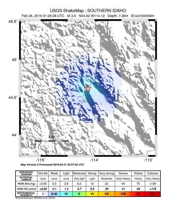
The USGS ShakeMap: shaking estimated from seismic stations and the quake’s size, on the Modified Mercalli intensity scale.
- Strongest estimated
- III, weak shaking
- Map
- Automatic
Did you feel it?
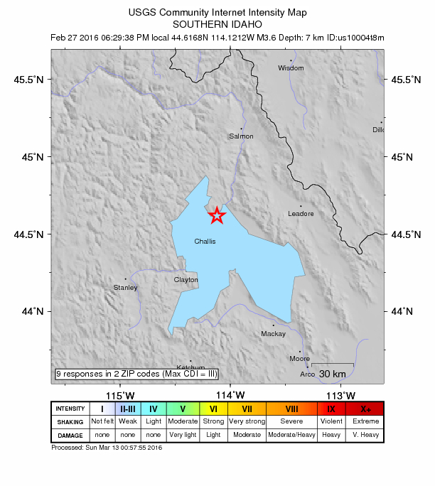
9 people reported to the USGS what they felt; the strongest reported shaking was III, weak shaking.
How well it is located
Reviewed by a seismologist.
- Location uncertainty
- About 3.5 km horizontally, 6.3 km in depth
- Magnitude uncertainty
- ±0.19
- Station coverage gap
- 54°
- Stations used
- 29
Nearest places
Distance and direction from each place to the epicenter, with its forecast.
Nearby
Within 100 km, magnitude 1.5 and up: 28 in the 60 days after this one and 31 in the 30 days before it.
After
- 1.722 km WNW of Challis, Idaho · 3868 days ago · 5 km deep · 32 km away
- 2.114 km NE of Challis, Idaho · 3868 days ago · 5 km deep · 1 km away
- 1.622 km WNW of Challis, Idaho · 3868 days ago · 4 km deep · 31 km away
- 2.122 km W of Challis, Idaho · 3867 days ago · 5 km deep · 32 km away
- 1.724 km WNW of Challis, Idaho · 3867 days ago · 8 km deep · 33 km away
- 1.623 km W of Challis, Idaho · 3867 days ago · 2 km deep · 33 km away
- 1.714 km NE of Challis, Idaho · 3867 days ago · -2 km deep · 2 km away
- 2.223 km WNW of Challis, Idaho · 3867 days ago · 7 km deep · 32 km away
- 2.013 km SE of Challis, Idaho · 3866 days ago · 5 km deep · 20 km away
- 1.622 km WNW of Challis, Idaho · 3866 days ago · 7 km deep · 31 km away
- 1.514 km W of Clayton, Idaho · 3865 days ago · 6 km deep · 55 km away
- 2.523 km W of Challis, Idaho · 3864 days ago · 1 km deep · 33 km away
- 1.714 km NE of Challis, Idaho · 3863 days ago · 5 km deep · 4 km away
- 1.822 km W of Challis, Idaho · 3860 days ago · 4 km deep · 32 km away
- 2.614 km NE of Challis, Idaho · 3854 days ago · 10 km deep · 1 km away
- 1.8southern Idaho · 3854 days ago · 7 km deep · 14 km away
- 1.525 km SE of Challis, Idaho · 3854 days ago · 5 km deep · 31 km away
- 2.2southern Idaho · 3854 days ago · 9 km deep · 2 km away
- 1.622 km WNW of Challis, Idaho · 3851 days ago · 3 km deep · 31 km away
- 1.917 km NNE of Challis, Idaho · 3850 days ago · 5 km deep · 2 km away · felt by 1
- 1.622 km WNW of Challis, Idaho · 3848 days ago · 5 km deep · 31 km away
- 1.639 km NNE of Leadore, Idaho · 3847 days ago · 5 km deep · 89 km away
- 1.510 km SE of Challis, Idaho · 3843 days ago · 5 km deep · 20 km away
- 1.629 km E of Clayton, Idaho · 3841 days ago · 5 km deep · 44 km away
- 1.722 km WNW of Challis, Idaho · 3840 days ago · 6 km deep · 32 km away
- 1.919 km NE of Challis, Idaho · 3833 days ago · 7 km deep · 5 km away
- 1.514 km NE of Challis, Idaho · 3818 days ago · 6 km deep · 1 km away
- 1.64 km NW of Challis, Idaho · 3813 days ago · 7 km deep · 16 km away
Before
- 2.316 km NNE of Challis, Idaho · 3869 days ago · 6 km deep · 2 km away
- 2.022 km WNW of Challis, Idaho · 3870 days ago · 7 km deep · 32 km away
- 1.821 km W of Challis, Idaho · 3870 days ago · 3 km deep · 31 km away
- 3.314 km NNE of Challis, Idaho · 3870 days ago · 6 km deep · 1 km away · felt by 1
- 3.223 km WNW of Challis, Idaho · 3870 days ago · 7 km deep · 32 km away
- 1.823 km WNW of Challis, Idaho · 3872 days ago · 5 km deep · 32 km away
- 1.722 km WNW of Challis, Idaho · 3875 days ago · 7 km deep · 31 km away
- 2.223 km WNW of Challis, ID · 3875 days ago · 6 km deep · 32 km away
- 1.622 km W of Challis, Idaho · 3875 days ago · 5 km deep · 32 km away
- 1.914 km SE of Challis, Idaho · 3880 days ago · 7 km deep · 23 km away
- 1.512 km SE of Challis, Idaho · 3881 days ago · 6 km deep · 21 km away
- 1.810 km NW of Challis, Idaho · 3882 days ago · -1 km deep · 17 km away
- 1.920 km SE of Challis, Idaho · 3882 days ago · 3 km deep · 28 km away
- 1.512 km SE of Challis, Idaho · 3883 days ago · 6 km deep · 20 km away
- 2.212 km SE of Challis, Idaho · 3887 days ago · 8 km deep · 21 km away
- 1.813 km SE of Challis, Idaho · 3887 days ago · 7 km deep · 21 km away
- 2.315 km W of Clayton, Idaho · 3888 days ago · 8 km deep · 54 km away
- 1.822 km WNW of Challis, Idaho · 3894 days ago · 6 km deep · 32 km away
- 1.622 km WNW of Challis, Idaho · 3894 days ago · 5 km deep · 32 km away
- 1.819 km SE of Challis, Idaho · 3894 days ago · 2 km deep · 26 km away
Earthquakes todayIdaho earthquakesLive radar here
Sources
From the USGS Earthquake Hazards Program and its partner networks, event us10004t8m (also filed as mb80127094). Read Thu, Oct 1, 2026, 12:57 PM UTC.