M3.9 earthquake 38 km SE of Akutan, Alaska
A magnitude 3.9 earthquake struck 38 km SE of Akutan, Alaska on Tue, Dec 20, 2016, 6:49 PM AKST (03:49 UTC), 63 km (39 mi) below the surface.
A larger quake followed: M4.5 107 km SSW of False Pass, Alaska. This one was a foreshock.
Map
Where this earthquake was located, with the others nearby. Select one for its page.
The earthquake
- Magnitude
- 3.9 (mb, body-wave), minor
- Magnitude from
- USGS National Earthquake Information Center
- Local time
- UTC
- 2016-12-21 03:49:30 UTC
- Depth
- 63.0 km (39.2 mi), shallow
- Epicenter
- 53.929° N, 165.297° W
- Region
- Alaska
- Felt reports
- 1
- Strongest shaking
- III, weak shaking
- Tsunami flag
- No
- Status
- Reviewed by a seismologist
Magnitude estimates
Different scales measure different things and differ by a few tenths. The USGS marks one as preferred, and it is the one this page uses.
| Mag. | Scale | Computed by | Notes |
|---|---|---|---|
| 3.9 | mb, body-wave | USGS National Earthquake Information Center | Preferred · Reviewed · ±0.154 · 11 stations |
| 3.8 | ML, local (Richter) | Alaska Earthquake Center | Preliminary |
What happened
The USGS’s account of the effects of this earthquake.
Felt at Unalaska.
From the USGS event page for us10007met. U.S. Geological Survey text and figures are in the public domain.
Shaking
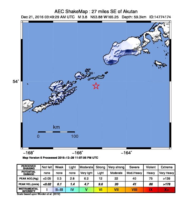
The USGS ShakeMap: shaking estimated from seismic stations and the quake’s size, on the Modified Mercalli intensity scale.
- Strongest estimated
- III, weak shaking
- Map
- Automatic
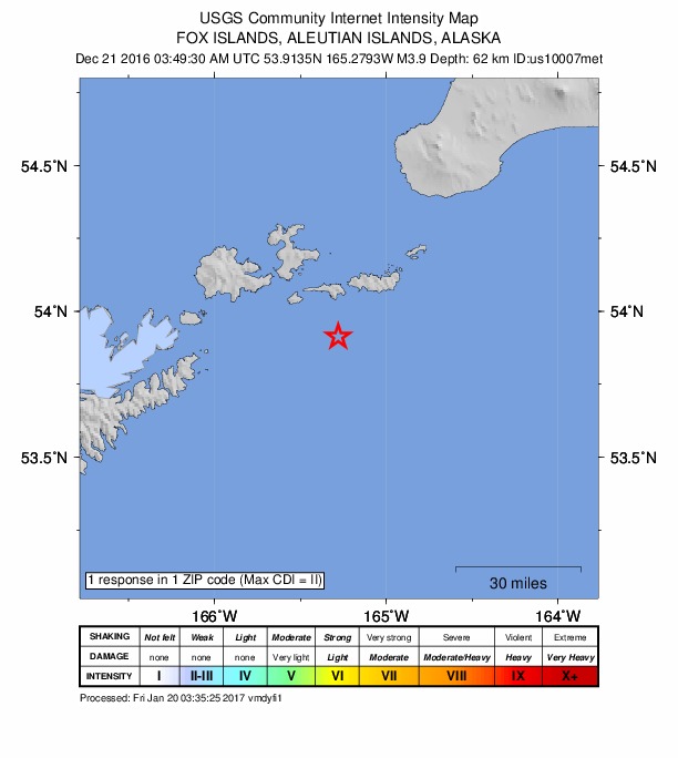
Did you feel it?
1 person reported to the USGS what they felt; the strongest reported shaking was II, weak shaking.
How well it is located
Reviewed by a seismologist.
- Location uncertainty
- About 9.2 km horizontally, 10.8 km in depth
- Magnitude uncertainty
- ±0.15
- Depth from
- From location
- Station coverage gap
- 184°, poorly surrounded by stations
- Stations used
- 45
Nearest places
Distance and direction from each place to the epicenter, with its forecast.
Nearby
Within 100 km, magnitude 1.5 and up: 107 in the 60 days after this one and 55 in the 30 days before it.
After
- 2.028 km SSE of Unalaska, Alaska · 3574 days ago · 93 km deep · 73 km away
- 2.390 km NE of Akutan, Alaska · 3574 days ago · 111 km deep · 94 km away
- 1.622 km SSW of Akutan, Alaska · 3573 days ago · 83 km deep · 44 km away
- 2.6124 km ESE of Akutan, Alaska · 3572 days ago · 35 km deep · 87 km away
- 2.073 km SSW of False Pass, Alaska · 3572 days ago · 54 km deep · 98 km away
- 2.3105 km ESE of Akutan, Alaska · 3572 days ago · 28 km deep · 70 km away
- 4.087 km SE of Akutan, Alaska · 3571 days ago · 28 km deep · 53 km away
- 2.283 km SE of Akutan, Alaska · 3570 days ago · 46 km deep · 47 km away
- 2.280 km SE of Akutan, Alaska · 3570 days ago · 51 km deep · 43 km away
- 1.949 km S of Akutan, Alaska · 3570 days ago · 61 km deep · 39 km away
- 2.694 km E of Akutan, Alaska · 3570 days ago · 51 km deep · 62 km away
- 3.550 km ENE of Akutan, Alaska · 3569 days ago · 98 km deep · 44 km away
- 2.214 km SSW of Unalaska, Alaska · 3568 days ago · 83 km deep · 87 km away
- 2.010 km NNW of Akutan, Alaska · 3566 days ago · 105 km deep · 47 km away
- 3.616 km ESE of Unalaska, Alaska · 3566 days ago · 72 km deep · 68 km away
- 1.613 km W of Akutan, Alaska · 3565 days ago · 6 km deep · 51 km away
- 2.3103 km ESE of Akutan, Alaska · 3564 days ago · 62 km deep · 69 km away
- 2.5114 km SSW of False Pass, Alaska · 3561 days ago · 41 km deep · 93 km away
- 2.035 km S of Unalaska, Alaska · 3561 days ago · 85 km deep · 86 km away
- 2.280 km ESE of Akutan, Alaska · 3561 days ago · 53 km deep · 42 km away
- 2.2105 km SE of Akutan, Alaska · 3561 days ago · 14 km deep · 66 km away
- 3.926 km SSW of Unalaska, Alaska · 3561 days ago · 63 km deep · 94 km away · felt by 1
- 1.775 km SE of Unalaska, Alaska · 3561 days ago · 26 km deep · 57 km away
- 2.082 km E of Akutan, Alaska · 3560 days ago · 59 km deep · 55 km away
- 2.148 km SE of Akutan, Alaska · 3560 days ago · 58 km deep · 10 km away
- 2.544 km SE of Akutan, Alaska · 3559 days ago · 65 km deep · 5 km away
- 2.3112 km ESE of Akutan, Alaska · 3558 days ago · 52 km deep · 77 km away
- 2.032 km SE of Akutan, Alaska · 3558 days ago · 68 km deep · 8 km away
- 2.2109 km SSW of False Pass, Alaska · 3557 days ago · 26 km deep · 83 km away
- 1.656 km SE of Akutan, Alaska · 3557 days ago · 46 km deep · 23 km away
- 1.813 km ENE of Akutan, Alaska · 3557 days ago · 79 km deep · 32 km away
- 2.268 km SW of False Pass, Alaska · 3557 days ago · 91 km deep · 91 km away
- 2.1118 km ESE of Akutan, Alaska · 3556 days ago · 29 km deep · 83 km away
- 1.664 km SSE of Akutan, Alaska · 3555 days ago · 26 km deep · 40 km away
- 2.169 km ESE of Akutan, Alaska · 3555 days ago · 58 km deep · 31 km away
- 2.672 km E of Akutan, Alaska · 3554 days ago · 77 km deep · 49 km away
- 3.966 km SSE of Unalaska, Alaska · 3553 days ago · 32 km deep · 94 km away · felt by 2
- 3.479 km SSE of Akutan, Alaska · 3553 days ago · 46 km deep · 53 km away
- 2.029 km SE of Akutan, Alaska · 3553 days ago · 79 km deep · 11 km away
- 3.479 km WSW of False Pass, Alaska · 3553 days ago · 5 km deep · 90 km away
- 1.728 km SE of Unalaska, Alaska · 3552 days ago · 70 km deep · 69 km away
- 2.4103 km ESE of Akutan, Alaska · 3549 days ago · 61 km deep · 69 km away
- 3.896 km SSW of False Pass, Alaska · 3549 days ago · 15 km deep · 74 km away
- 1.664 km SE of Unalaska, Alaska · 3549 days ago · 45 km deep · 57 km away
- 3.191 km SSW of False Pass, Alaska · 3548 days ago · 14 km deep · 80 km away
- 1.934 km E of Akutan, Alaska · 3547 days ago · 74 km deep · 22 km away
- 1.951 km NE of Akutan, Alaska · 3547 days ago · 95 km deep · 58 km away
- 1.737 km SSE of Unalaska, Alaska · 3546 days ago · 63 km deep · 83 km away
- 2.080 km ESE of Akutan, Alaska · 3546 days ago · 25 km deep · 43 km away
- 1.870 km SE of Akutan, Alaska · 3545 days ago · 55 km deep · 34 km away
- 1.868 km SE of Unalaska, Alaska · 3545 days ago · 35 km deep · 62 km away
- 1.873 km SSE of Akutan, Alaska · 3545 days ago · 38 km deep · 40 km away
- 2.899 km SE of Akutan, Alaska · 3544 days ago · 33 km deep · 60 km away
- 2.2100 km SE of Akutan, Alaska · 3544 days ago · 48 km deep · 62 km away
- 2.074 km SSE of Akutan, Alaska · 3543 days ago · 45 km deep · 45 km away
- 2.735 km S of Akutan, Alaska · 3542 days ago · 71 km deep · 38 km away
- 2.167 km SE of Unalaska, Alaska · 3542 days ago · 33 km deep · 69 km away
- 2.377 km SE of Akutan, Alaska · 3542 days ago · 47 km deep · 42 km away
- 2.588 km SE of Unalaska, Alaska · 3541 days ago · 34 km deep · 75 km away
- 2.7102 km ESE of Akutan, Alaska · 3541 days ago · 47 km deep · 67 km away
The first 60 of 107.
Before
- 3.1104 km ESE of Akutan, Alaska · 3574 days ago · 31 km deep · 69 km away
- 1.759 km SSE of Akutan, Alaska · 3575 days ago · 21 km deep · 36 km away
- 3.037 km SE of Akutan, Alaska · 3575 days ago · 65 km deep · 2 km away
- 2.270 km E of Akutan, Alaska · 3576 days ago · 60 km deep · 39 km away
- 2.5110 km SSW of False Pass, Alaska · 3577 days ago · 46 km deep · 82 km away
- 2.4115 km ESE of Akutan, Alaska · 3578 days ago · 26 km deep · 80 km away
- 3.582 km SSW of False Pass, Alaska · 3578 days ago · 77 km deep · 84 km away
- 2.3106 km ESE of Akutan, Alaska · 3579 days ago · 51 km deep · 72 km away
- 3.5112 km ESE of Akutan, Alaska · 3579 days ago · 46 km deep · 77 km away
- 4.1120 km ESE of Akutan, Alaska · 3579 days ago · 28 km deep · 83 km away
- 2.5126 km SE of Akutan, Alaska · 3579 days ago · 37 km deep · 91 km away
- 3.4127 km SE of Akutan, Alaska · 3579 days ago · 10 km deep · 91 km away
- 3.9134 km SE of Akutan, Alaska · 3579 days ago · 13 km deep · 98 km away
- 2.4125 km SE of Akutan, Alaska · 3580 days ago · 69 km deep · 89 km away
- 2.599 km ESE of Akutan, Alaska · 3580 days ago · 65 km deep · 66 km away
- 2.574 km SSE of Akutan, Alaska · 3580 days ago · 56 km deep · 40 km away
- 2.296 km ESE of Akutan, Alaska · 3582 days ago · 22 km deep · 57 km away
- 2.285 km SE of Akutan, Alaska · 3582 days ago · 58 km deep · 47 km away
- 2.069 km SSE of Akutan, Alaska · 3583 days ago · 55 km deep · 38 km away
- 3.9Fox Islands, Aleutian Islands, Alaska · 3583 days ago · 114 km deep · 67 km away
Earthquakes todayAlaska earthquakesLive radar here
Sources
From the USGS Earthquake Hazards Program and its partner networks, event us10007met (also filed as ak14774174, ak016gcteeym). Read Sat, Oct 3, 2026, 11:40 PM UTC.