M5.9 earthquake 13 km NNW of Viña del Mar, Chile
A magnitude 5.9 earthquake struck 13 km NNW of Viña del Mar, Chile on Thu, Sep 17, 2015, 9:14 AM GMT-3 (12:14 UTC), 10 km (6 mi) below the surface.
A larger quake followed: M6.2 92 km NW of Valparaíso, Chile. This one was a foreshock.
Map
Where this earthquake was located, with the others nearby. Select one for its page.
The earthquake
- Magnitude
- 5.9 (Mww, W-phase moment), moderate
- Magnitude from
- USGS National Earthquake Information Center
- Local time
- UTC
- 2015-09-17 12:14:34 UTC
- Depth
- 10.0 km (6.2 mi), shallow
- Epicenter
- 32.915° S, 71.606° W
- Region
- Chile
- Felt reports
- 1
- Strongest shaking
- VII, very strong shaking
- PAGER alert
- Green
- Tsunami flag
- No
- Status
- Reviewed by a seismologist
Magnitude estimates
Different scales measure different things and differ by a few tenths. The USGS marks one as preferred, and it is the one this page uses.
| Mag. | Scale | Computed by | Notes |
|---|---|---|---|
| 5.9 | Mww, W-phase moment | USGS National Earthquake Information Center | Preferred · Reviewed |
| 5.86 | Mw, moment | ISC-GEM global catalog | Final · ±0.1 |
| 5.9 | Mwc, centroid moment | USGS National Earthquake Information Center | Moment tensor · Reviewed |
What happened
The USGS’s account of the effects of this earthquake.
Felt (III) at Los Vilos, Tiltil and Valparaiso; (II) at Calle Larga, El Monte, San Felipe and Santiago.
From the USGS event page for us20003kkw. U.S. Geological Survey text and figures are in the public domain.
Shaking
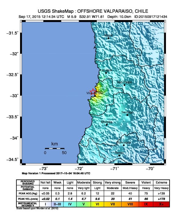
The USGS ShakeMap: shaking estimated from seismic stations and the quake’s size, on the Modified Mercalli intensity scale.
- Strongest estimated
- VII, very strong shaking
- Map
- Automatic
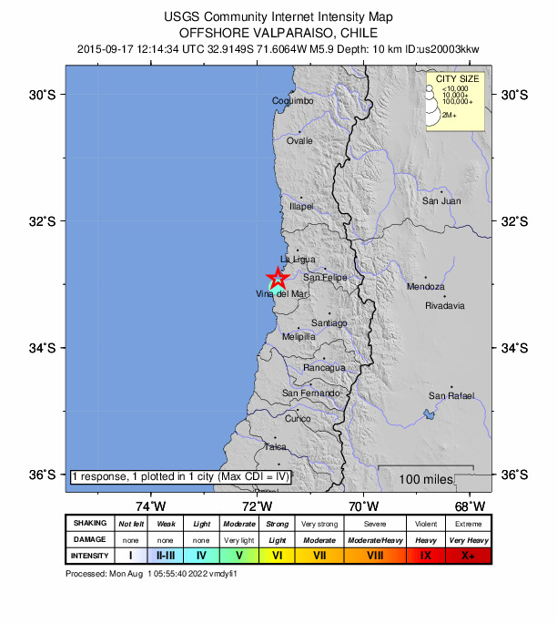
Did you feel it?
1 person reported to the USGS what they felt; the strongest reported shaking was IV, light shaking.
Estimated impact
The USGS PAGER system estimates deaths and economic losses from the shaking and the population and buildings exposed to it.
- Alert level
- Green: little or no damage or loss of life expected
Fault motion and ground failure
How the rock slipped, from the moment tensor, and the USGS estimate of landslides and liquefaction.
- Faulting
- Reverse (thrust)
- Moment magnitude
- 5.9 Mww
- Nodal plane 1
- Strike 166°, dip 78°, rake 91°
- Nodal plane 2
- Strike 341°, dip 12°, rake 85°
How well it is located
Reviewed by a seismologist.
- Location uncertainty
- About 5.7 km horizontally, 1.8 km in depth
- Depth from
- Operator assigned
- Station coverage gap
- 54°
- Stations used
- 63
Nearest places
Distance and direction from each place to the epicenter, with its forecast.
Nearby
Within 100 km, magnitude 2.9 and up: 66 in the 60 days after this one and 1 in the 30 days before it.
After
- 4.670 km WNW of La Ligua, Chile · 4036 days ago · 10 km deep · 86 km away
- 4.544 km NW of La Ligua, Chile · 4035 days ago · 35 km deep · 82 km away
- 4.778 km WNW of La Ligua, Chile · 4035 days ago · 3 km deep · 79 km away
- 5.066 km WNW of La Ligua, Chile · 4035 days ago · 16 km deep · 72 km away
- 4.289 km NW of Valparaíso, Chile · 4035 days ago · 14 km deep · 81 km away
- 4.687 km NW of Valparaíso, Chile · 4035 days ago · 16 km deep · 78 km away
- 6.292 km NW of Valparaíso, Chile · 4035 days ago · 8 km deep · 84 km away · felt by 24
- 4.4104 km NW of Valparaíso, Chile · 4035 days ago · 10 km deep · 96 km away
- 4.572 km WNW of La Ligua, Chile · 4035 days ago · 11 km deep · 84 km away
- 4.2106 km NW of Valparaíso, Chile · 4034 days ago · 10 km deep · 98 km away
- 4.488 km W of La Ligua, Chile · 4034 days ago · 10 km deep · 83 km away
- 4.4Off the coast of Valparaiso, Chile · 4034 days ago · 9 km deep · 98 km away
- 4.170 km WNW of La Ligua, Chile · 4034 days ago · 14 km deep · 73 km away
- 3.963 km WNW of La Ligua, Chile · 4034 days ago · 15 km deep · 72 km away
- 4.541 km NNW of La Ligua, Chile · 4034 days ago · 35 km deep · 88 km away · felt by 3
- 6.279 km W of La Ligua, Chile · 4034 days ago · 18 km deep · 78 km away · felt by 49
- 4.956 km W of La Ligua, Chile · 4034 days ago · 32 km deep · 57 km away
- 3.758 km W of La Ligua, Chile · 4033 days ago · 35 km deep · 62 km away
- 4.377 km NNW of Valparaíso, Chile · 4033 days ago · 35 km deep · 69 km away
- 4.270 km WNW of La Ligua, Chile · 4033 days ago · 10 km deep · 78 km away
- 4.280 km WNW of La Ligua, Chile · 4033 days ago · 10 km deep · 81 km away
- 4.478 km NNW of Valparaíso, Chile · 4033 days ago · 10 km deep · 69 km away
- 4.298 km NW of Valparaíso, Chile · 4033 days ago · 10 km deep · 92 km away
- 3.774 km W of La Ligua, Chile · 4033 days ago · 10 km deep · 71 km away
- 4.570 km WNW of La Ligua, Chile · 4033 days ago · 14 km deep · 75 km away
- 4.283 km NW of Valparaíso, Chile · 4033 days ago · 16 km deep · 75 km away
- 4.294 km NW of Valparaíso, Chile · 4033 days ago · 9 km deep · 86 km away
- 4.1Off the coast of Valparaiso, Chile · 4033 days ago · 18 km deep · 81 km away
- 4.2100 km WNW of La Ligua, Chile · 4033 days ago · 9 km deep · 100 km away
- 4.283 km WNW of La Ligua, Chile · 4033 days ago · 24 km deep · 86 km away
- 4.343 km W of Valparaíso, Chile · 4033 days ago · 25 km deep · 49 km away
- 4.284 km W of La Ligua, Chile · 4033 days ago · 13 km deep · 78 km away
- 4.274 km WNW of La Ligua, Chile · 4033 days ago · 22 km deep · 92 km away
- 4.655 km W of La Ligua, Chile · 4033 days ago · 17 km deep · 49 km away
- 4.480 km W of La Ligua, Chile · 4032 days ago · 6 km deep · 76 km away
- 4.474 km WNW of La Ligua, Chile · 4032 days ago · 8 km deep · 81 km away
- 4.040 km W of Valparaíso, Chile · 4032 days ago · 17 km deep · 45 km away
- 4.298 km NW of Valparaíso, Chile · 4032 days ago · 29 km deep · 91 km away
- 4.792 km NW of Valparaíso, Chile · 4032 days ago · 10 km deep · 83 km away · felt by 1
- 4.448 km W of Valparaíso, Chile · 4031 days ago · 12 km deep · 53 km away · felt by 1
- 4.488 km WNW of La Ligua, Chile · 4031 days ago · 16 km deep · 96 km away
- 4.4Off the coast of Valparaiso, Chile · 4031 days ago · 16 km deep · 93 km away · felt by 8
- 4.326 km SSE of Villa Alemana, Chile · 4030 days ago · 49 km deep · 49 km away · felt by 2
- 4.063 km WNW of La Ligua, Chile · 4030 days ago · 16 km deep · 74 km away
- 4.397 km NW of Valparaíso, Chile · 4029 days ago · 10 km deep · 89 km away
- 4.7Off the coast of Valparaiso, Chile · 4028 days ago · 10 km deep · 82 km away
- 4.498 km W of La Ligua, Chile · 4028 days ago · 10 km deep · 92 km away · felt by 1
- 4.2104 km NW of Valparaíso, Chile · 4028 days ago · 14 km deep · 96 km away
- 4.295 km W of La Ligua, Chile · 4028 days ago · 6 km deep · 90 km away
- 4.375 km WNW of Valparaíso, Chile · 4027 days ago · 10 km deep · 76 km away
- 4.351 km W of Valparaíso, Chile · 4024 days ago · 19 km deep · 55 km away · felt by 2
- 4.145 km W of Valparaíso, Chile · 4024 days ago · 23 km deep · 50 km away · felt by 1
- 4.6Off the coast of Valparaiso, Chile · 4023 days ago · 15 km deep · 54 km away · felt by 1
- 4.553 km WNW of Valparaíso, Chile · 4021 days ago · 10 km deep · 50 km away
- 4.148 km WNW of Valparaíso, Chile · 4021 days ago · 13 km deep · 45 km away
- 4.054 km WNW of Valparaíso, Chile · 4020 days ago · 14 km deep · 51 km away · felt by 1
- 4.387 km WNW of La Ligua, Chile · 4020 days ago · 6 km deep · 90 km away
- 4.261 km NW of La Ligua, Chile · 4017 days ago · 35 km deep · 89 km away
- 4.267 km NW of La Ligua, Chile · 4017 days ago · 23 km deep · 94 km away
- 4.163 km NW of La Ligua, Chile · 4011 days ago · 37 km deep · 91 km away
The first 60 of 66.
Before
Earthquakes todayChile earthquakesLive radar here
Sources
From the USGS Earthquake Hazards Program and its partner networks, event us20003kkw (also filed as gcmt20150917121434, gcmt20150917121435, iscgem608098265, atlas20150917121434). Read Mon, Oct 5, 2026, 12:59 AM UTC.