M5.0 earthquake 15 km WSW of Nueva Concepción, Guatemala
A magnitude 5.0 earthquake struck 15 km WSW of Nueva Concepción, Guatemala on Fri, Jul 31, 2015, 5:39 PM CST (23:39 UTC), 63 km (39 mi) below the surface.
A larger quake followed: M5.2 11 km S of Nueva Concepción, Guatemala. This one was a foreshock.
Map
Where this earthquake was located, with the others nearby. Select one for its page.
The earthquake
- Magnitude
- 5.0 (Mwr, regional moment), moderate
- Magnitude from
- USGS National Earthquake Information Center
- Local time
- UTC
- 2015-07-31 23:39:25 UTC
- Depth
- 63.4 km (39.4 mi), shallow
- Epicenter
- 14.130° N, 91.421° W
- Region
- Guatemala
- Felt reports
- 41
- Tsunami flag
- No
- Status
- Reviewed by a seismologist
Magnitude estimates
Different scales measure different things and differ by a few tenths. The USGS marks one as preferred, and it is the one this page uses.
| Mag. | Scale | Computed by | Notes |
|---|---|---|---|
| 5.0 | Mwr, regional moment | USGS National Earthquake Information Center | Preferred · Reviewed · ±0.073 · 18 stations |
| 5.09 | Mw, moment | ISC-GEM global catalog | Final · ±0.1 |
What happened
The USGS’s account of the effects of this earthquake.
Felt (III) at Antigua Guatemala, Guatemala City, Santa Catarina Pinula and Villa Nueva. Also felt at Chinautla, Ciudad Vieja, Lanquin, Mazatenango, Mixco, Olintepeque, Panajachel, San Antonio Aguas Calientes, San Pablo La Laguna and San Pedro La Laguna. Felt (III) at San Salvador, El Salvador.
From the USGS event page for us10002x0r. U.S. Geological Survey text and figures are in the public domain.
Did you feel it?
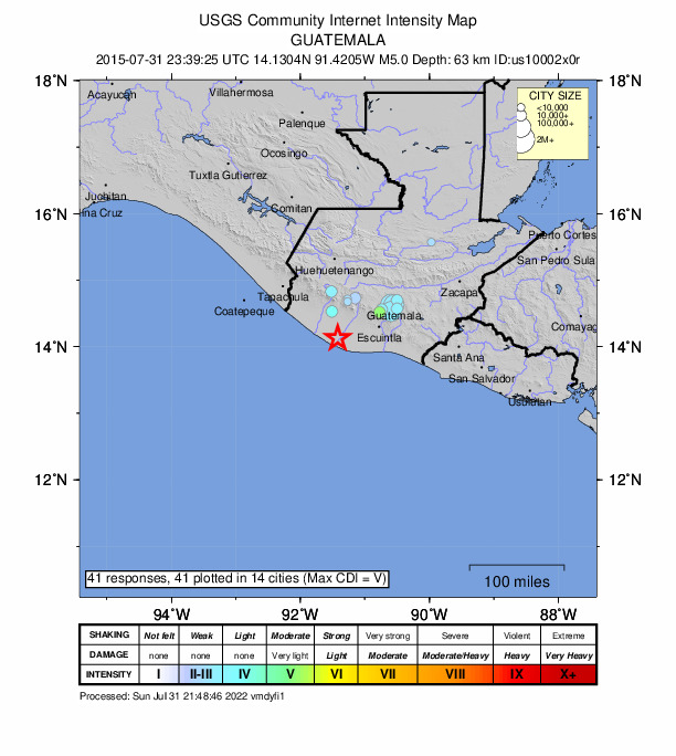
41 people reported to the USGS what they felt; the strongest reported shaking was V, moderate shaking.
Fault motion and ground failure
How the rock slipped, from the moment tensor, and the USGS estimate of landslides and liquefaction.
- Faulting
- Oblique reverse
- Moment magnitude
- 5.0 Mwr
- Nodal plane 1
- Strike 76°, dip 33°, rake 40°
- Nodal plane 2
- Strike 310°, dip 69°, rake 116°
How well it is located
Reviewed by a seismologist.
- Location uncertainty
- About 6.3 km horizontally, 3.3 km in depth
- Magnitude uncertainty
- ±0.07
- Depth from
- From location
- Station coverage gap
- 32°
- Stations used
- 847
Nearest places
Distance and direction from each place to the epicenter, with its forecast.
Nearby
Within 100 km, magnitude 2.0 and up: 11 in the 60 days after this one and 7 in the 30 days before it.
After
- 4.77 km ENE of Concepción, Guatemala · 4082 days ago · 205 km deep · 84 km away
- 4.159 km SSW of Nueva Concepción, Guatemala · 4074 days ago · 77 km deep · 48 km away
- 4.35 km NNW of La Gomera, Guatemala · 4071 days ago · 92 km deep · 38 km away · felt by 2
- 5.211 km S of Nueva Concepción, Guatemala · 4070 days ago · 58 km deep · 14 km away · felt by 20
- 4.915 km ESE of La Gomera, Guatemala · 4068 days ago · 80 km deep · 55 km away · felt by 34
- 4.3Guatemala · 4062 days ago · 67 km deep · 28 km away · felt by 5
- 4.735 km SSE of Champerico, Guatemala · 4053 days ago · 46 km deep · 46 km away
- 4.363 km S of Champerico, Guatemala · 4034 days ago · 35 km deep · 62 km away
- 4.259 km SSE of Champerico, Guatemala · 4031 days ago · 44 km deep · 47 km away
- 4.267 km SW of Nueva Concepción, Guatemala · 4031 days ago · 66 km deep · 55 km away
- 3.9near the coast of Chiapas, Mexico · 4025 days ago · 86 km deep · 86 km away
Before
- 4.250 km SSW of La Gomera, Guatemala · 4089 days ago · 14 km deep · 56 km away
- 4.340 km SSW of Champerico, Guatemala · 4090 days ago · 49 km deep · 73 km away
- 4.238 km SW of Champerico, Guatemala · 4095 days ago · 52 km deep · 78 km away
- 4.010 km SSE of Iztapa, Guatemala · 4103 days ago · 66 km deep · 87 km away
- 4.28 km SSW of La Gomera, Guatemala · 4104 days ago · 63 km deep · 39 km away · felt by 1
- 4.28 km ENE of Nueva Concepción, Guatemala · 4108 days ago · 65 km deep · 23 km away · felt by 4
- 4.38 km SSW of Nueva Concepción, Guatemala · 4110 days ago · 60 km deep · 10 km away · felt by 1
Earthquakes todayGuatemala earthquakesLive radar here
Sources
From the USGS Earthquake Hazards Program and its partner networks, event us10002x0r (also filed as iscgem607575607). Read Sun, Oct 4, 2026, 9:56 PM UTC.