M3.5 earthquake 21 km SSW of Mammoth, Wyoming
A magnitude 3.5 earthquake struck 21 km SSW of Mammoth, Wyoming on Sat, May 31, 2014, 4:25 PM MDT (22:25 UTC), 5 km (3 mi) below the surface.
Automatic solution: the magnitude and location may still be revised.
Map
Where this earthquake was located, with the others nearby. Select one for its page.
The earthquake
- Magnitude
- 3.5 (ML, local (Richter)), minor
- Magnitude from
- University of Utah Seismograph Stations
- Local time
- UTC
- 2014-05-31 22:25:00 UTC
- Depth
- 4.7 km (2.9 mi), shallow
- Epicenter
- 44.791° N, 110.776° W
- Region
- Montana
- Strongest shaking
- III, weak shaking
- Tsunami flag
- No
- Status
- Automatic solution, may be revised
Magnitude estimates
Different scales measure different things and differ by a few tenths. The USGS marks one as preferred, and it is the one this page uses.
| Mag. | Scale | Computed by | Notes |
|---|---|---|---|
| 3.5 | ML, local (Richter) | University of Utah Seismograph Stations | Preferred · Reviewed · ±0.2 · 6 stations |
| 3.3 | Mwr, regional moment | USGS National Earthquake Information Center | Reviewed · 13 stations |
Shaking
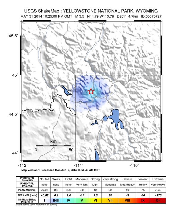
The USGS ShakeMap: shaking estimated from seismic stations and the quake’s size, on the Modified Mercalli intensity scale.
- Strongest estimated
- III, weak shaking
- Map
- Automatic
Did you feel it?
No one has reported feeling this quake to the USGS.
Fault motion and ground failure
How the rock slipped, from the moment tensor, and the USGS estimate of landslides and liquefaction.
- Faulting
- Strike-slip
- Moment magnitude
- 3.3 Mwr
- Nodal plane 1
- Strike 325°, dip 80°, rake 25°
- Nodal plane 2
- Strike 230°, dip 65°, rake 169°
How well it is located
An automatic solution; a seismologist may revise it.
- Location uncertainty
- About 0.5 km horizontally, 0.7 km in depth
- Magnitude uncertainty
- ±0.20
- Station coverage gap
- 112°
- Stations used
- 14
Nearest places
Distance and direction from each place to the epicenter, with its forecast.
Nearby
Within 100 km, magnitude 1.5 and up: 122 in the 60 days after this one and 50 in the 30 days before it.
After
- 2.221 km SSW of Mammoth, Wyoming · 4508 days ago · 4 km deep · 1 km away
- 1.620 km SSW of Mammoth, Wyoming · 4508 days ago · 5 km deep · 1 km away
- 1.820 km SSW of Mammoth, Wyoming · 4508 days ago · 4 km deep · 1 km away
- 2.420 km SSW of Mammoth, Wyoming · 4508 days ago · 6 km deep · 1 km away
- 2.421 km SSW of Mammoth, Wyoming · 4508 days ago · 4 km deep · 1 km away
- 2.121 km SSW of Mammoth, Wyoming · 4508 days ago · 5 km deep · 1 km away
- 2.021 km SSW of Mammoth, Wyoming · 4508 days ago · 5 km deep · 1 km away
- 1.722 km SSW of Mammoth, Wyoming · 4508 days ago · 5 km deep · 2 km away
- 1.521 km SSW of Mammoth, Wyoming · 4508 days ago · 5 km deep · 1 km away
- 1.521 km SSW of Mammoth, Wyoming · 4508 days ago · 4 km deep · 1 km away
- 1.920 km SSW of Mammoth, Wyoming · 4508 days ago · 4 km deep · 1 km away
- 1.619 km SSW of Mammoth, Wyoming · 4508 days ago · 2 km deep · 2 km away
- 1.521 km SSW of Mammoth, Wyoming · 4507 days ago · 4 km deep · 1 km away
- 1.620 km SSW of Mammoth, Wyoming · 4507 days ago · 5 km deep · 1 km away
- 1.921 km SSW of Mammoth, Wyoming · 4507 days ago · 5 km deep · 1 km away
- 1.518 km S of Mammoth, Wyoming · 4507 days ago · 8 km deep · 3 km away
- 1.518 km SSW of Mammoth, Wyoming · 4507 days ago · 8 km deep · 3 km away
- 1.722 km SSW of Mammoth, Wyoming · 4507 days ago · 5 km deep · 1 km away
- 1.515 km S of Mammoth, Wyoming · 4507 days ago · 8 km deep · 7 km away
- 2.022 km SSW of Mammoth, Wyoming · 4507 days ago · 5 km deep · 1 km away
- 2.321 km SSW of Mammoth, Wyoming · 4507 days ago · 4 km deep · 1 km away
- 1.922 km SSW of Mammoth, Wyoming · 4507 days ago · 2 km deep · 2 km away
- 2.422 km SSW of Mammoth, Wyoming · 4507 days ago · 5 km deep · 1 km away
- 2.322 km SSW of Mammoth, Wyoming · 4507 days ago · 5 km deep · 1 km away
- 2.019 km SSW of Mammoth, Wyoming · 4506 days ago · 8 km deep · 3 km away
- 1.820 km SSW of Mammoth, Wyoming · 4506 days ago · 6 km deep · 2 km away
- 1.619 km SSW of Mammoth, Wyoming · 4506 days ago · 7 km deep · 3 km away
- 1.518 km SSW of Mammoth, Wyoming · 4506 days ago · 7 km deep · 3 km away
- 1.522 km SSW of Mammoth, Wyoming · 4506 days ago · 4 km deep · 1 km away
- 3.420 km SSW of Mammoth, Wyoming · 4506 days ago · 10 km deep · 1 km away · felt by 4
- 2.421 km SSW of Mammoth, Wyoming · 4506 days ago · 5 km deep · 2 km away
- 1.519 km SSW of Mammoth, Wyoming · 4506 days ago · 7 km deep · 3 km away
- 2.921 km SSW of Mammoth, Wyoming · 4506 days ago · 9 km deep · 1 km away
- 1.520 km SSW of Mammoth, Wyoming · 4506 days ago · 5 km deep · 2 km away
- 1.617 km S of Mammoth, Wyoming · 4506 days ago · 8 km deep · 5 km away
- 1.620 km SSW of Mammoth, Wyoming · 4506 days ago · 5 km deep · 2 km away
- 3.122 km SSW of Mammoth, Wyoming · 4506 days ago · 8 km deep · 2 km away
- 1.521 km SSW of Mammoth, Wyoming · 4506 days ago · 4 km deep · 1 km away
- 1.621 km SSW of Mammoth, Wyoming · 4506 days ago · 6 km deep · 1 km away
- 1.516 km S of Mammoth, Wyoming · 4506 days ago · 7 km deep · 6 km away
- 2.220 km SSW of Mammoth, Wyoming · 4506 days ago · 8 km deep · 1 km away
- 1.721 km SSW of Mammoth, Wyoming · 4506 days ago · 5 km deep · 1 km away
- 2.222 km SSW of Mammoth, Wyoming · 4506 days ago · 4 km deep · 1 km away
- 1.620 km SSW of Mammoth, Wyoming · 4506 days ago · 5 km deep · 2 km away
- 2.119 km SSW of Mammoth, Wyoming · 4506 days ago · 6 km deep · 2 km away
- 1.616 km S of Mammoth, Wyoming · 4506 days ago · 7 km deep · 5 km away
- 2.120 km SSW of Mammoth, Wyoming · 4506 days ago · 7 km deep · 2 km away
- 2.221 km SSW of Mammoth, Wyoming · 4506 days ago · 5 km deep · 1 km away
- 1.520 km SSW of Mammoth, Wyoming · 4506 days ago · 5 km deep · 1 km away
- 1.518 km S of Mammoth, Wyoming · 4506 days ago · 10 km deep · 3 km away
- 1.8Wyoming · 4506 days ago · 8 km deep · 3 km away
- 1.620 km SSW of Mammoth, Wyoming · 4506 days ago · 5 km deep · 1 km away
- 1.719 km SSW of Mammoth, Wyoming · 4506 days ago · 8 km deep · 2 km away
- 1.617 km SSW of Mammoth, Wyoming · 4506 days ago · 7 km deep · 4 km away
- 2.220 km S of Mammoth, Wyoming · 4506 days ago · 7 km deep · 2 km away
- 1.6Wyoming · 4506 days ago · 4 km deep · 1 km away
- 2.120 km SSW of Mammoth, Wyoming · 4505 days ago · 5 km deep · 2 km away
- 2.018 km SSW of Mammoth, Wyoming · 4505 days ago · 7 km deep · 3 km away
- 2.122 km SSW of Mammoth, Wyoming · 4505 days ago · 6 km deep · 1 km away
- 2.122 km SSW of Mammoth, Wyoming · 4505 days ago · 5 km deep · 1 km away
The first 60 of 122.
Before
- 2.121 km SSW of Mammoth, Wyoming · 4508 days ago · 4 km deep · 1 km away
- 1.719 km SSW of Mammoth, Wyoming · 4508 days ago · 5 km deep · 3 km away
- 1.620 km SSW of Mammoth, Wyoming · 4509 days ago · 4 km deep · 1 km away
- 1.719 km SSW of Mammoth, Wyoming · 4509 days ago · 5 km deep · 2 km away
- 2.821 km SSW of Mammoth, Wyoming · 4509 days ago · 5 km deep · 1 km away
- 2.621 km SSW of Mammoth, Wyoming · 4509 days ago · 5 km deep · 1 km away
- 1.529 km ESE of West Yellowstone, Montana · 4511 days ago · 6 km deep · 24 km away
- 2.130 km ESE of West Yellowstone, Montana · 4511 days ago · 8 km deep · 23 km away
- 1.929 km ESE of West Yellowstone, Montana · 4511 days ago · 9 km deep · 23 km away
- 1.529 km ESE of West Yellowstone, Montana · 4511 days ago · 3 km deep · 24 km away
- 1.630 km ESE of West Yellowstone, Montana · 4511 days ago · 8 km deep · 23 km away
- 1.530 km ESE of West Yellowstone, Montana · 4511 days ago · 8 km deep · 23 km away
- 2.030 km ESE of West Yellowstone, Montana · 4511 days ago · 8 km deep · 23 km away
- 1.58 km SSW of West Yellowstone, Montana · 4512 days ago · 9 km deep · 36 km away
- 1.758 km SSE of Mammoth, Wyoming · 4515 days ago · 2 km deep · 46 km away
- 2.211 km NNE of West Yellowstone, Montana · 4515 days ago · 8 km deep · 22 km away
- 1.841 km S of Virginia City, Montana · 4517 days ago · 10 km deep · 90 km away
- 1.522 km SSW of Mammoth, Wyoming · 4518 days ago · 9 km deep · 1 km away
- 1.824 km SSW of Mammoth, Wyoming · 4518 days ago · 6 km deep · 3 km away
- 1.922 km SSW of Mammoth, Wyoming · 4518 days ago · 9 km deep · 1 km away
Earthquakes todayMontana earthquakesLive radar here
Sources
From the USGS Earthquake Hazards Program and its partner networks, event uu60070727 (also filed as usc000r9mf). Read Sun, Oct 4, 2026, 7:57 AM UTC.