M4.8 earthquake 22 km S of Mammoth, Wyoming
A magnitude 4.8 earthquake struck 22 km S of Mammoth, Wyoming on Sun, Mar 30, 2014, 6:34 AM MDT (12:34 UTC), 6 km (3 mi) below the surface.
Map
Where this earthquake was located, with the others nearby. Select one for its page.
The earthquake
- Magnitude
- 4.8 (Mw, moment), light
- Magnitude from
- University of Utah Seismograph Stations
- Local time
- UTC
- 2014-03-30 12:34:39 UTC
- Depth
- 5.6 km (3.5 mi), shallow
- Epicenter
- 44.772° N, 110.685° W
- Region
- Montana
- Felt reports
- 22
- Strongest shaking
- VI, strong shaking
- PAGER alert
- Green
- Tsunami flag
- No
- Status
- Reviewed by a seismologist
Magnitude estimates
Different scales measure different things and differ by a few tenths. The USGS marks one as preferred, and it is the one this page uses.
| Mag. | Scale | Computed by | Notes |
|---|---|---|---|
| 4.83 | Mw, moment | University of Utah Seismograph Stations | Preferred · Final · 0 stations |
| 4.8 | Mwr, regional moment | USGS National Earthquake Information Center | Reviewed · ±0.033 · 88 stations |
Shaking
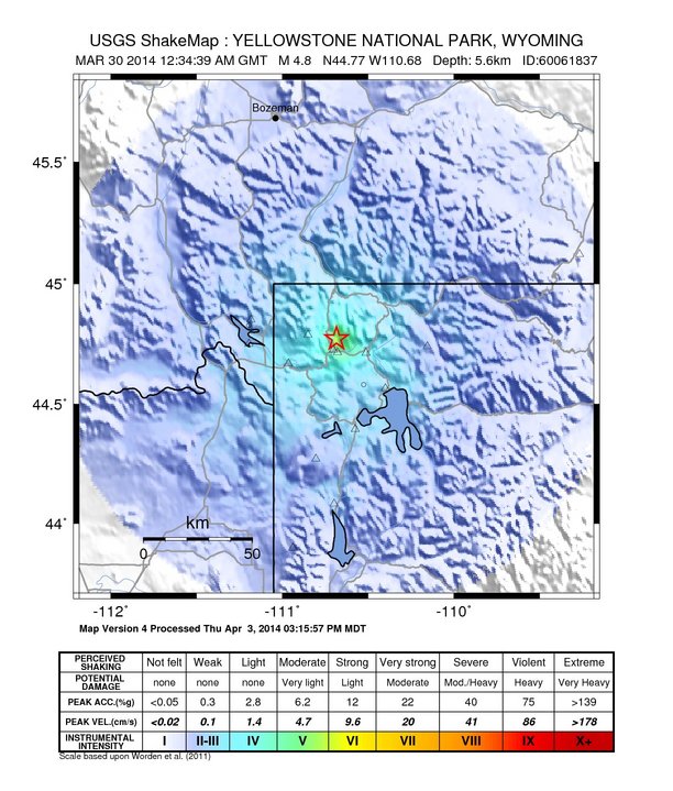
The USGS ShakeMap: shaking estimated from seismic stations and the quake’s size, on the Modified Mercalli intensity scale.
- Strongest estimated
- VI, strong shaking
- Map
- Automatic
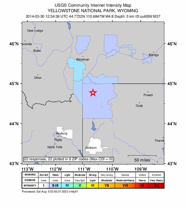
Did you feel it?
22 people reported to the USGS what they felt; the strongest reported shaking was III, weak shaking.
Estimated impact
The USGS PAGER system estimates deaths and economic losses from the shaking and the population and buildings exposed to it.
- Alert level
- Green: little or no damage or loss of life expected
More from the USGS
YELLOWSTONE VOLCANO OBSERVATORY INFORMATION STATEMENT
Sunday, March 30, 2014 10:31 AM (Sunday, March 30, 2014 16:31 UTC)
YELLOWSTONE VOLCANO (VNUM #325010)
44°25'48" N 110°40'12" W, Summit Elevation 9203 ft (2805 m)
Current Volcano Alert Level: NORMAL
Current Aviation Color Code: GREEN
The University of Utah, a YVO member agency, sent out the following press release about a magnitude 4.8 earthquake that occurred this morning at 6:34 AM MDT.
PRESS RELEASE
University of Utah Seismograph Stations
Released: March 30, 2014 08:15 AM MDT
The University of Utah Seismograph Stations reports that a light earthquake occurred at 06:34 AM on March 30, 2014 (MDT). The epicenter of the magnitude 4.8 shock was located 4 miles north-northeast of Norris Geyser Basin in Yellowstone National Park, Wyoming. This earthquake is part of a series of earthquakes that began in this area on Thursday, March 27. As of 8:15 am today, this series has included at least 25 earthquakes in addition to the main shock, with the largest of magnitude 3.1. The magnitude 4.8 main shock was reported felt in Yellowstone National Park and in the towns of West
Yellowstone and Gardiner, Montana.
Anyone who felt the earthquake is encouraged to fill out a survey form on either the Seismograph stations web site: www.quake.utah.edu or the U.S. Geological Survey web site: earthquake.usgs.gov.
____________________________________________________________________
Today's event is the largest earthquake at Yellowstone since February 22, 1980, and occurred near the center of a region of recent ground uplift described in a YVO Information Statement on February 18, 2014. The Yellowstone Volcano Observatory has been tracking this uplift episode for about 7 months.
As discussed in the March 3, 2014 YVO Monthly Update, seismicity in the general region of the uplift has been elevated for several months. A previous period of uplift in this area occurred between 1996 and 2003, and it was also accompanied by elevated seismicity.
A USGS field team is in Yellowstone and will visit the area near the earthquake's epicenter today. The team will look for any surface changes that the earthquake may have caused, and for possible effects to the hydrothermal system at Norris Geyser Basin.
Based on the style and location of today's earthquake, at this time YVO sees no indication of additional geologic activity other than continuing seismicity.
The Yellowstone Volcano Observatory (YVO) provides long-term monitoring of volcanic and earthquake activity in the Yellowstone National Park region. Yellowstone is the site of the largest and most diverse collection of natural thermal features in the world and the first National Park. YVO is one of the five USGS Volcano Observatories that monitor volcanoes within the United States for science and public safety.
YVO Member agencies: USGS, Yellowstone National Park, University of Utah, University of Wyoming, UNAVCO, Inc., Wyoming State Geological Survey, Montana Bureau of Mines and Geology, Idaho Geological Survey
From the USGS event page for uu60061837. U.S. Geological Survey text and figures are in the public domain.
How well it is located
Reviewed by a seismologist.
- Location uncertainty
- About 0.4 km horizontally, 0.8 km in depth
- Depth from
- From location
- Station coverage gap
- 63°
- Stations used
- 35
Nearest places
Distance and direction from each place to the epicenter, with its forecast.
Nearby
Within 100 km, magnitude 1.8 and up: 85 in the 60 days after this one and 38 in the 30 days before it.
After
- 2.122 km S of Mammoth, Wyoming · 4569 days ago · 2 km deep · 2 km away
- 2.023 km S of Mammoth, Wyoming · 4569 days ago · 4 km deep · 1 km away
- 2.0Wyoming · 4569 days ago · 3 km deep · 2 km away
- 2.623 km S of Mammoth, Wyoming · 4569 days ago · 4 km deep · 1 km away
- 1.923 km S of Mammoth, Wyoming · 4569 days ago · 4 km deep · 1 km away
- 2.620 km S of Mammoth, Wyoming · 4569 days ago · 4 km deep · 3 km away
- 1.924 km S of Mammoth, Wyoming · 4569 days ago · 2 km deep · 2 km away
- 3.5Wyoming · 4569 days ago · 4 km deep · 0 km away
- 2.121 km S of Mammoth, Wyoming · 4569 days ago · 4 km deep · 2 km away
- 2.423 km S of Mammoth, Wyoming · 4569 days ago · 3 km deep · 4 km away
- 1.922 km S of Mammoth, Wyoming · 4569 days ago · 4 km deep · 1 km away
- 2.923 km S of Mammoth, Wyoming · 4569 days ago · 4 km deep · 3 km away
- 2.323 km S of Mammoth, Wyoming · 4569 days ago · 3 km deep · 3 km away
- 1.928 km S of Mammoth, Wyoming · 4569 days ago · 5 km deep · 5 km away
- 1.922 km S of Mammoth, Wyoming · 4569 days ago · 3 km deep · 2 km away
- 2.622 km S of Mammoth, Wyoming · 4569 days ago · 4 km deep · 1 km away
- 1.923 km S of Mammoth, Wyoming · 4569 days ago · 2 km deep · 4 km away
- 2.122 km S of Mammoth, Wyoming · 4569 days ago · 4 km deep · 1 km away
- 2.224 km S of Mammoth, Wyoming · 4569 days ago · 4 km deep · 1 km away
- 3.420 km S of Mammoth, Wyoming · 4569 days ago · 5 km deep · 2 km away
- 1.922 km S of Mammoth, Wyoming · 4569 days ago · 2 km deep · 3 km away
- 3.721 km S of Mammoth, Wyoming · 4569 days ago · 3 km deep · 3 km away
- 2.019 km S of Mammoth, Wyoming · 4569 days ago · 2 km deep · 3 km away
- 2.423 km S of Mammoth, Wyoming · 4569 days ago · 7 km deep · 3 km away
- 2.018 km S of Mammoth, Wyoming · 4569 days ago · 4 km deep · 5 km away
- 2.018 km S of Mammoth, Wyoming · 4569 days ago · 4 km deep · 4 km away
- 2.023 km S of Mammoth, Wyoming · 4569 days ago · 5 km deep · 1 km away
- 1.8Wyoming · 4569 days ago · 4 km deep · 2 km away
- 2.323 km S of Mammoth, Wyoming · 4569 days ago · 4 km deep · 3 km away
- 2.122 km S of Mammoth, Wyoming · 4569 days ago · 4 km deep · 3 km away
- 2.722 km S of Mammoth, Wyoming · 4569 days ago · 5 km deep · 2 km away
- 2.323 km S of Mammoth, Wyoming · 4569 days ago · 3 km deep · 2 km away
- 2.923 km S of Mammoth, Wyoming · 4569 days ago · 4 km deep · 3 km away
- 1.921 km S of Mammoth, Wyoming · 4569 days ago · 5 km deep · 3 km away
- 1.921 km S of Mammoth, Wyoming · 4569 days ago · 4 km deep · 2 km away
- 2.0Wyoming · 4569 days ago · 3 km deep · 0 km away
- 2.125 km S of Mammoth, Wyoming · 4568 days ago · 3 km deep · 3 km away
- 2.323 km S of Mammoth, Wyoming · 4567 days ago · 4 km deep · 2 km away
- 2.223 km S of Mammoth, Wyoming · 4567 days ago · 4 km deep · 2 km away
- 2.424 km S of Mammoth, Wyoming · 4567 days ago · 5 km deep · 2 km away
- 2.224 km S of Mammoth, Wyoming · 4567 days ago · 4 km deep · 3 km away
- 1.923 km S of Mammoth, Wyoming · 4567 days ago · 3 km deep · 2 km away
- 1.924 km S of Mammoth, Wyoming · 4567 days ago · 4 km deep · 3 km away
- 2.122 km S of Mammoth, Wyoming · 4567 days ago · 4 km deep · 2 km away
- 1.924 km S of Mammoth, Wyoming · 4567 days ago · 4 km deep · 2 km away
- 2.122 km S of Mammoth, Wyoming · 4567 days ago · 4 km deep · 3 km away
- 3.125 km S of Mammoth, Wyoming · 4567 days ago · 4 km deep · 3 km away
- 1.924 km S of Mammoth, Wyoming · 4567 days ago · 4 km deep · 3 km away
- 2.244 km NE of Spencer, Idaho · 4567 days ago · 7 km deep · 94 km away
- 2.027 km S of Mammoth, Wyoming · 4567 days ago · 2 km deep · 8 km away
- 1.926 km S of Mammoth, Wyoming · 4567 days ago · 8 km deep · 7 km away
- 2.022 km S of Mammoth, Wyoming · 4566 days ago · 4 km deep · 1 km away
- 2.117 km ENE of Hebgen Lake Estates, Montana · 4566 days ago · 9 km deep · 25 km away
- 2.126 km S of Mammoth, Wyoming · 4565 days ago · 8 km deep · 7 km away
- 2.515 km S of West Yellowstone, Montana · 4565 days ago · 14 km deep · 45 km away
- 2.126 km SSW of Mammoth, Wyoming · 4563 days ago · 8 km deep · 8 km away
- 2.419 km SSW of Mammoth, Wyoming · 4562 days ago · 5 km deep · 8 km away
- 2.827 km ENE of West Yellowstone, Montana · 4562 days ago · 5 km deep · 9 km away
- 2.527 km ENE of West Yellowstone, Montana · 4562 days ago · 5 km deep · 8 km away
- 2.127 km SSW of Mammoth, Wyoming · 4562 days ago · 8 km deep · 8 km away
The first 60 of 85.
Before
- 2.523 km S of Mammoth, Wyoming · 4569 days ago · 4 km deep · 1 km away
- 2.325 km S of Mammoth, Wyoming · 4569 days ago · 2 km deep · 3 km away
- 2.022 km S of Mammoth, Wyoming · 4569 days ago · 4 km deep · 0 km away
- 3.422 km S of Mammoth, Wyoming · 4569 days ago · 4 km deep · 0 km away
- 2.420 km S of Mammoth, Wyoming · 4569 days ago · 4 km deep · 3 km away
- 1.922 km S of Mammoth, Wyoming · 4569 days ago · 3 km deep · 1 km away
- 3.021 km S of Mammoth, Wyoming · 4569 days ago · 4 km deep · 2 km away
- 2.021 km SE of Mammoth, Wyoming · 4571 days ago · 7 km deep · 15 km away
- 2.021 km SSE of Mammoth, Wyoming · 4571 days ago · 4 km deep · 4 km away
- 2.117 km SSW of Mammoth, Wyoming · 4572 days ago · 4 km deep · 9 km away
- 2.520 km SSW of Mammoth, Wyoming · 4572 days ago · 6 km deep · 8 km away
- 1.919 km SSW of Mammoth, Wyoming · 4572 days ago · 4 km deep · 8 km away
- 2.220 km SSW of Mammoth, Wyoming · 4572 days ago · 4 km deep · 8 km away
- 2.217 km SSW of Mammoth, Wyoming · 4572 days ago · 4 km deep · 9 km away
- 2.020 km SSW of Mammoth, Wyoming · 4572 days ago · 4 km deep · 8 km away
- 3.520 km SSW of Mammoth, Wyoming · 4572 days ago · 5 km deep · 8 km away
- 2.118 km SSW of Mammoth, Wyoming · 4573 days ago · 4 km deep · 8 km away
- 3.019 km SSW of Mammoth, Wyoming · 4573 days ago · 6 km deep · 8 km away
- 2.023 km SSW of Mammoth, Wyoming · 4576 days ago · 8 km deep · 7 km away
- 2.325 km SSW of Mammoth, Wyoming · 4577 days ago · 8 km deep · 8 km away
Earthquakes todayMontana earthquakesLive radar here
Sources
From the USGS Earthquake Hazards Program and its partner networks, event uu60061837 (also filed as usc000nwtr). Read Fri, Oct 2, 2026, 8:10 AM UTC.