M7.1 earthquake 23 km NE of Constitución, Chile
A magnitude 7.1 earthquake struck 23 km NE of Constitución, Chile on Sun, Mar 25, 2012, 7:37 PM GMT-3 (22:37 UTC), 41 km (25 mi) below the surface.
Map
Where this earthquake was located, with the others nearby. Select one for its page.
The earthquake
- Magnitude
- 7.1 (Mww, W-phase moment), major
- Magnitude from
- USGS National Earthquake Information Center
- Local time
- UTC
- 2012-03-25 22:37:06 UTC
- Depth
- 40.7 km (25.3 mi), shallow
- Epicenter
- 35.200° S, 72.217° W
- Region
- Chile
- Felt reports
- 1,122
- Strongest shaking
- VII, very strong shaking
- Tsunami flag
- No
- Status
- Reviewed by a seismologist
Magnitude estimates
Different scales measure different things and differ by a few tenths. The USGS marks one as preferred, and it is the one this page uses.
| Mag. | Scale | Computed by | Notes |
|---|---|---|---|
| 7.1 | Mww, W-phase moment | USGS National Earthquake Information Center | Preferred · Reviewed |
| 7.12 | Mw, moment | ISC-GEM global catalog | Final · ±0.1 |
| 6.96 | Me, energy | Choy, USGS energy magnitude | Reviewed |
| 7.1 | Mww, W-phase moment | Duputel, W-phase inversion | Preliminary |
Deaths and damage
From NOAA NCEI’s Significant Earthquake Database (record 9920), matched to this event by time and place.
- Deaths
- 1
- Injuries
- 14
- Damage
- $100 million
- Houses damaged
- Some (about 51 to 100)
Where the literature gives no number, NCEI records a description on a scale of 1 to 4, printed here in its words. Damage is in millions of US dollars of the year of the event, not adjusted for inflation.
From Wikipedia
The 2012 Constitución earthquake was recorded on March 25, 2012, at 7:37 pm local time. It had a moment magnitude of 7.1 and its epicenter was located 23 km (14 mi) northeast of the city of Constitución, in the Maule Region, Chile. According to experts, it was a strong and late aftershock of the Great Chile earthquake of February 27, 2010.
The earthquake was felt from Coquimbo to the Los Lagos Region, with the Maule Region being the most affected and causing high commotion in the O'Higgins and Bio-bío regions, which were affected by the earthquake of 2010.
Text from Wikipedia, “2012 Constitución earthquake”, licensed CC BY-SA 4.0. Quoted as written; the full article has the rest.
The article is about the earthquake NOAA’s record describes, matched to this one by date, place and magnitude.
What happened
The USGS’s account of the effects of this earthquake.
One person died from a heart attack at Parral, at least 11 people injured in the Santiago area and 3 injured in Bio-Bio. Some buildings damaged slightly at Santiago. Felt (VIII) at Cauquenes, Constitucion, Pelluhue and Talca; (VII) at Cobquecura, Linares, Molina, Parral, Pelarco, Rengo, Rio Claro and Villa Alegre. Felt strongly throughout south-central Chile. Felt (IV) at Mendoza and San Martin; (III) at Buenos Aires, San Juan and San Rafael, Argentina.
From the USGS event page for usp000jgsw. U.S. Geological Survey text and figures are in the public domain.
Shaking
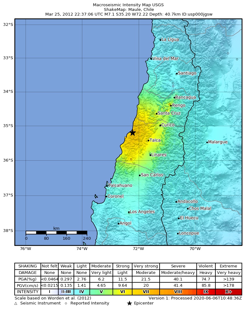
The USGS ShakeMap: shaking estimated from seismic stations and the quake’s size, on the Modified Mercalli intensity scale.
- Strongest estimated
- VII, very strong shaking
- Peak ground acceleration
- 29.6% of gravity
- Peak ground velocity
- 3.3 cm/s
- Map
- Automatic
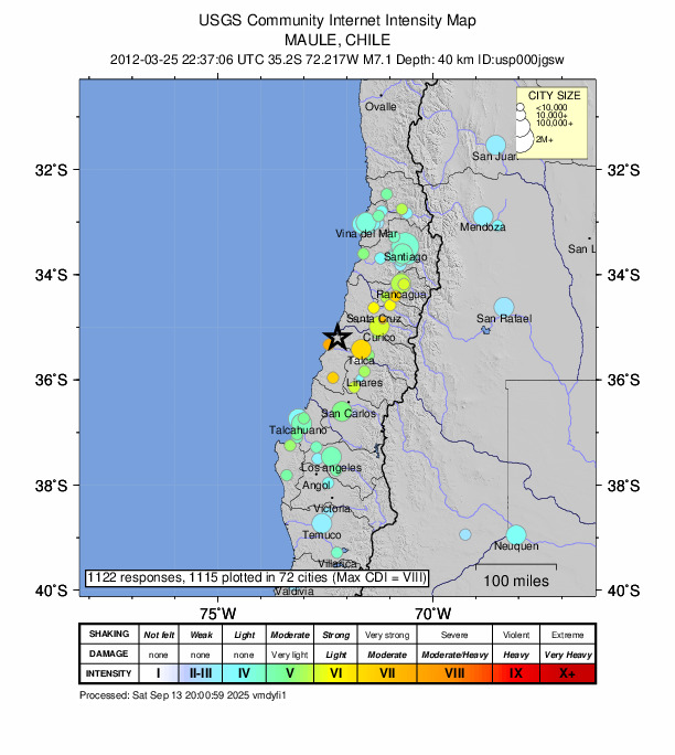
Did you feel it?
1,122 people reported to the USGS what they felt; the strongest reported shaking was VIII, severe shaking.
Fault motion and ground failure
How the rock slipped, from the moment tensor, and the USGS estimate of landslides and liquefaction.
- Faulting
- Reverse (thrust)
- Moment magnitude
- 7.1 Mww
- Nodal plane 1
- Strike 182°, dip 72°, rake 85°
- Nodal plane 2
- Strike 17°, dip 17°, rake 104°
Tectonic setting
Why earthquakes happen here, from the USGS tectonic summary.
The March 25, 2012, M 7.1 Maule, Chile earthquake occurred as the result of shallow thrust faulting on or near the subduction interface between the Nazca and South America plates. At the location of this event, the Nazca plate moves east-northeast relative to South America at a velocity of about 74 mm/yr. The Nazca plate, oceanic in origin, subducts eastward beneath the South America plate at a shallow angle from the Peru-Chile Trench. It is seismically active to depths of approximately 200 km adjacent to the epicenter of the March 25th earthquake, though farther north seismicity continues to depths exceeding 600 km.
The March 25th earthquake occurred within the aftershock zone of the damaging M 8.8 Maule earthquake of February 27, 2010, and can also be considered an aftershock of that event. The subduction zone between the Nazca and South America plates has a long history of large megathrust earthquakes, including the largest event ever recorded, a M 9.5 earthquake in 1960, which ruptured a fault mostly to the south of the March 25th earthquake.
Hayes et al. (2016) Tectonic summaries of magnitude 7 and greater earthquakes from 2000 to 2015, USGS Open-File Report 2016-1192. (5.2 MB PDF)
From the USGS event page for usp000jgsw. U.S. Geological Survey text and figures are in the public domain.
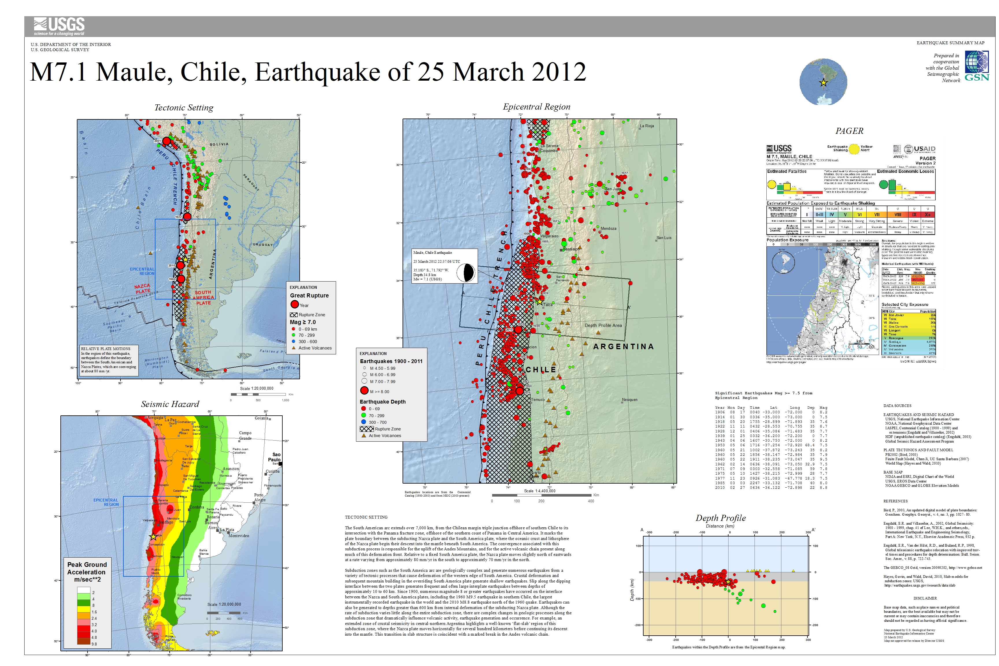
USGS summary poster
How well it is located
Reviewed by a seismologist.
- Station coverage gap
- 15°
- Stations used
- 553
Nearest places
Distance and direction from each place to the epicenter, with its forecast.
Nearby
Within 100 km, magnitude 4.1 and up: 12 in the 60 days after this one and 7 in the 30 days before it.
After
- 4.636 km NW of Constitución, Chile · 5303 days ago · 44 km deep · 44 km away
- 4.447 km NE of Constitución, Chile · 5302 days ago · 35 km deep · 26 km away
- 4.124 km NNW of Constitución, Chile · 5302 days ago · 13 km deep · 25 km away
- 4.7Near the coast of Maule, Chile · 5300 days ago · 16 km deep · 80 km away
- 4.122 km N of Constitución, Chile · 5300 days ago · 17 km deep · 23 km away
- 4.525 km NE of Constitución, Chile · 5298 days ago · 38 km deep · 3 km away
- 4.430 km ENE of Constitución, Chile · 5297 days ago · 43 km deep · 14 km away
- 4.148 km SW of Constitución, Chile · 5291 days ago · 13 km deep · 71 km away
- 4.738 km ENE of Constitución, Chile · 5284 days ago · 40 km deep · 18 km away
- 4.740 km NNW of Talca, Chile · 5270 days ago · 43 km deep · 30 km away · felt by 14
- 4.733 km WSW of Santa Cruz, Chile · 5270 days ago · 43 km deep · 70 km away · felt by 4
- 4.3Maule, Chile · 5251 days ago · 118 km deep · 90 km away
Before
- 4.633 km NE of Cauquenes, Chile · 5307 days ago · 67 km deep · 68 km away
- 4.932 km W of Rauco, Chile · 5316 days ago · 70 km deep · 56 km away · felt by 34
- 4.374 km NNW of Constitución, Chile · 5319 days ago · 39 km deep · 73 km away
- 4.964 km WNW of Cauquenes, Chile · 5325 days ago · 10 km deep · 91 km away · felt by 4
- 4.635 km SW of Constitución, Chile · 5325 days ago · 28 km deep · 59 km away
- 4.763 km WNW of Cauquenes, Chile · 5325 days ago · 10 km deep · 90 km away
- 5.049 km WNW of Cauquenes, Chile · 5325 days ago · 13 km deep · 81 km away · felt by 12
Earthquakes todayChile earthquakesLive radar here
Sources
From the USGS Earthquake Hazards Program and its partner networks, event usp000jgsw (also filed as usc0008pwq, choy20120325223706, duputel201203252237a, iscgem600841739, atlas20120325223706). Read Thu, Oct 1, 2026, 11:21 AM UTC.