M6.9 earthquake 27 km NNW of Tachilek, Myanmar
A magnitude 6.9 earthquake struck 27 km NNW of Tachilek, Myanmar on Thu, Mar 24, 2011, 8:25 PM GMT+6:30 (13:55 UTC), 8 km (5 mi) below the surface.
Map
Where this earthquake was located, with the others nearby. Select one for its page.
The earthquake
- Magnitude
- 6.9 (Mww, W-phase moment), strong
- Magnitude from
- USGS National Earthquake Information Center
- Local time
- UTC
- 2011-03-24 13:55:12 UTC
- Depth
- 8.0 km (5.0 mi), shallow
- Epicenter
- 20.687° N, 99.822° E
- Region
- Myanmar
- Felt reports
- 649
- Strongest shaking
- IX, violent shaking
- Tsunami flag
- No
- Status
- Reviewed by a seismologist
Magnitude estimates
Different scales measure different things and differ by a few tenths. The USGS marks one as preferred, and it is the one this page uses.
| Mag. | Scale | Computed by | Notes |
|---|---|---|---|
| 6.9 | Mww, W-phase moment | USGS National Earthquake Information Center | Preferred · Reviewed |
| 6.84 | Mw, moment | ISC-GEM global catalog | Final · ±0.1 |
| 7.0 | Me, energy | Choy, USGS energy magnitude | Reviewed |
| 6.8 | Mww, W-phase moment | Duputel, W-phase inversion | Preliminary |
Deaths and damage
From NOAA NCEI’s Significant Earthquake Database (record 9801), matched to this event by time and place.
- Deaths
- 104
- Injuries
- 123
- Damage
- $3.6 million
- Houses damaged
- 10,104
Where the literature gives no number, NCEI records a description on a scale of 1 to 4, printed here in its words. Damage is in millions of US dollars of the year of the event, not adjusted for inflation.
From Wikipedia
The 2011 Shan earthquake occurred on 24 March in Shan State, Myanmar. The earthquake measured Mw 6.8 and had an epicenter northwest of the border between Myanmar, Thailand and Laos. It occurred in a region accommodating tectonic deformation brought by the collision between the Indo-Australian and Eurasian plates. Strike-slip faulting along the Nan Ma Fault was identified as the cause. There were between 75 and 151 fatalities; including one death in Thailand. An additional 212 people were injured. Hundreds of buildings and some transport infrastructure were damaged in Myanmar and Thailand. In the aftermath of the disaster, the Burmese government provided aid and relief supplies to the affected region. Neighbouring countries China, India and Thailand provided monetary assistance. Several international humanitarian organizations also supported in the relief and recovery.
Text from Wikipedia, “2011 Shan earthquake”, licensed CC BY-SA 4.0. Quoted as written; the full article has the rest.
The article is about the earthquake NOAA’s record describes, matched to this one by date, place and magnitude.
Wikidata records: 75 deaths and 212 injured. These are counts entered by Wikidata’s editors; they may differ from the official count, and this page never adds them to another figure. Q150495, CC0.
What happened
The USGS’s account of the effects of this earthquake.
At least 74 people killed, 111 injured, 413 buildings damaged and one bridge collapsed in Shan. Landslides occurred in the area. Felt (VI) at Kengtung and (II) at Rangoon. Also felt at Mandalay and Taunggyi. One person killed in northern Thailand. Felt (VI) at Mae Sai; (IV) at Amnat Charoen, Chiang Rai, Lamphun, Mae Chan, Mae Rim, Nan, Nonthaburi, Phayao and Pong; (III) at Bangkok, Chiang Mai, Hang Dong, Lampang, Mae Hong Son, San Kamphaeng, San Pa Tong and San Sai. Twelve people injured, 9,496 people displaced and 9,691 houses, 136 reservoirs and 35 roads damaged in Yunnan, China. Felt (IV) at Jinghong, (III) at Nanning and (II) at Kunming. Felt (IV) at Louang Namtha and (II) at Louangphabang and Vientiane, Laos. Felt (III) at Hanoi, Vietnam. Also felt at Ho Chi Minh City. Felt widely in Laos, Myanmar, Thailand, Vietnam and southern China. Also felt at Phnom Penh, Cambodia and in Singapore. Felt at Dhaka, Bangladesh and at Aizawl, India.
From the USGS event page for usp000hyfx. U.S. Geological Survey text and figures are in the public domain.
Shaking
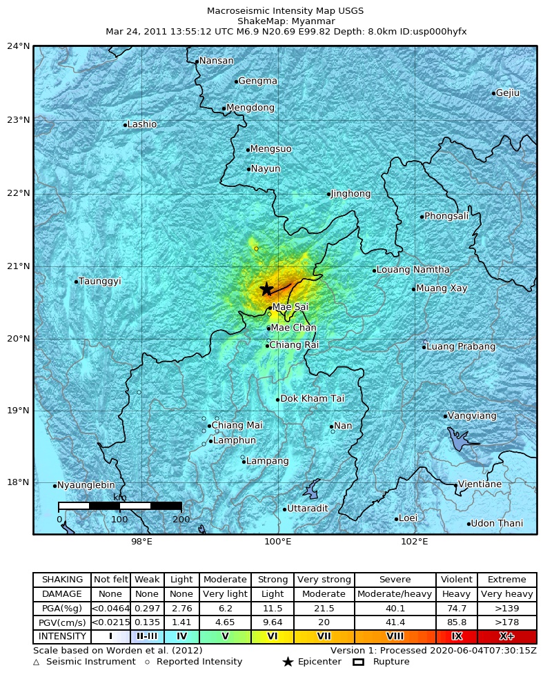
The USGS ShakeMap: shaking estimated from seismic stations and the quake’s size, on the Modified Mercalli intensity scale.
- Strongest estimated
- IX, violent shaking
- Peak ground acceleration
- 67.7% of gravity
- Peak ground velocity
- 4.5 cm/s
- Map
- Automatic
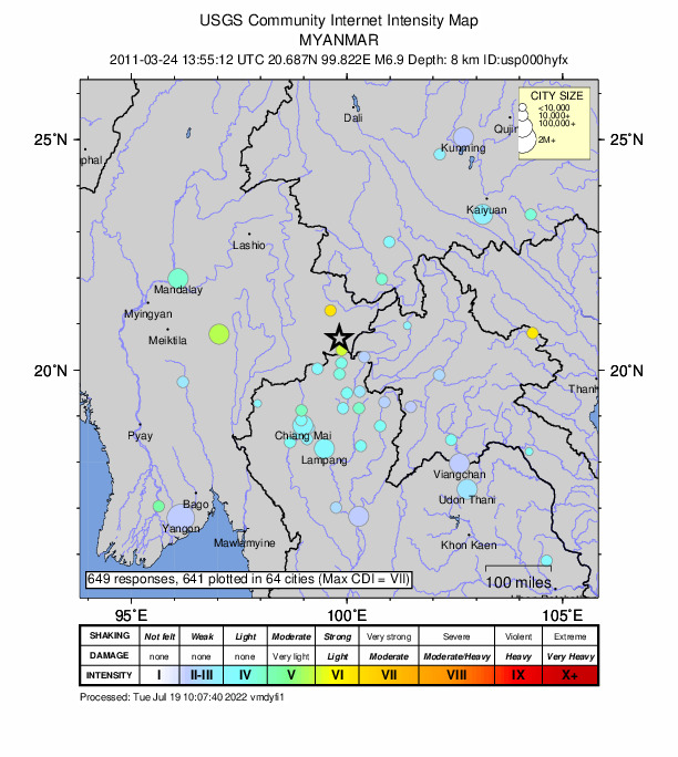
Did you feel it?
649 people reported to the USGS what they felt; the strongest reported shaking was VII, very strong shaking.
Fault motion and ground failure
How the rock slipped, from the moment tensor, and the USGS estimate of landslides and liquefaction.
- Faulting
- Strike-slip
- Moment magnitude
- 6.8 Mww
- Nodal plane 1
- Strike 70°, dip 86°, rake 12°
- Nodal plane 2
- Strike 339°, dip 77°, rake 176°
Tectonic setting
Why earthquakes happen here, from the USGS tectonic summary.
Present-day deformation and earthquakes in Myanmar and adjacent parts of southeast Asia are driven by the northward movement of the Indian subcontinent as it collides with the Eurasian plate. Myanmar, on the eastern side of this collisional zone, lies east of the boundary between the Indian plate to the west, and the Sunda plate. At the latitude of the March 24 earthquake, the Indian plate moves north-northeast with respect to the Sunda plate at a rate of approximately 45 mm/yr. Most of the differential motion between these two plates in Myanmar is concentrated on the Sagaing fault, which is a major north-striking, right-lateral fault that has a slip rate of approximately 18 mm/yr based on GPS data, and lies almost 400 km west of the March 24 earthquake. Numerous large earthquakes have occurred on the Sagaing fault in the past century, including a M 6.9 event in February 1991, which caused 2 fatalities.
Additional deformation caused by the collision between the Indian and Sunda plates extends to the east across Myanmar and into neighboring Thailand and northern Laos. In northeastern Myanmar, the collision is causing internal deformation in the Shan plateau and the Shan-Thai block, which are cut by a series of northeast-striking, left-lateral faults. These include, from south to north, the Mae Chan, Nam Ma, Menxing, Menglian, Nantinghe, Wanding, and Longling faults. The March 24 M 6.8 earthquake occurred in a region of distributed deformation in the Shan-Thai block. The closest nearby large and damaging earthquake in recent history was an M 6.8 event ~170 km to the north-northeast in July 1995, which caused 11 fatalities.
The focal mechanism of this event, indicating potential left-lateral slip on a northeast-trending nodal plane, is similar to the slip indicated by historical focal mechanisms throughout northeastern Myanmar.
From the USGS event page for usp000hyfx. U.S. Geological Survey text and figures are in the public domain.
How well it is located
Reviewed by a seismologist.
- Depth from
- OPERATOR_ASSIGNED
- Station coverage gap
- 18°
- Stations used
- 335
Nearest places
Distance and direction from each place to the epicenter, with its forecast.
Nearby
Within 100 km, magnitude 3.9 and up: 9 in the 60 days after this one and 0 in the 30 days before it.
After
- 4.823 km NNE of Tachilek, Myanmar · 5670 days ago · 11 km deep · 12 km away
- 5.725 km NNW of Tachilek, Myanmar · 5670 days ago · 10 km deep · 7 km away
- 4.444 km NE of Tachilek, Myanmar · 5670 days ago · 10 km deep · 36 km away
- 5.029 km N of Tachilek, Myanmar · 5670 days ago · 10 km deep · 7 km away · felt by 6
- 4.134 km WNW of Tachilek, Myanmar · 5670 days ago · 10 km deep · 27 km away
- 4.637 km NE of Tachilek, Myanmar · 5669 days ago · 8 km deep · 30 km away
- 5.040 km NE of Tachilek, Myanmar · 5668 days ago · 28 km deep · 31 km away
- 4.315 km NNW of Tachilek, Myanmar · 5668 days ago · 10 km deep · 13 km away
- 4.1Myanmar · 5668 days ago · 10 km deep · 17 km away
Earthquakes todayMyanmar earthquakesLive radar here
Sources
From the USGS Earthquake Hazards Program and its partner networks, event usp000hyfx (also filed as usc0002aes, choy20110324135512, duputel201103241355a, iscgem16357310, atlas20110324135512). Read Thu, Oct 1, 2026, 4:11 PM UTC.