M7.8 earthquake 75 km E of Sinabang, Indonesia
A magnitude 7.8 earthquake struck 75 km E of Sinabang, Indonesia on Wed, Apr 7, 2010, 5:15 AM GMT+7 (22:15 UTC), 31 km (19 mi) below the surface.
Map
Where this earthquake was located, with the others nearby. Select one for its page.
The earthquake
- Magnitude
- 7.8 (Mwc, centroid moment), major
- Magnitude from
- USGS National Earthquake Information Center
- Local time
- UTC
- 2010-04-06 22:15:01 UTC
- Depth
- 31.0 km (19.3 mi), shallow
- Epicenter
- 2.383° N, 97.048° E
- Region
- Indonesia
- Strongest shaking
- VII, very strong shaking
- Tsunami flag
- No
- Status
- Reviewed by a seismologist
Magnitude estimates
Different scales measure different things and differ by a few tenths. The USGS marks one as preferred, and it is the one this page uses.
| Mag. | Scale | Computed by | Notes |
|---|---|---|---|
| 7.8 | Mwc, centroid moment | USGS National Earthquake Information Center | Preferred · Reviewed |
| 7.82 | Mw, moment | ISC-GEM global catalog | Final · ±0.1 |
| 7.8 | Mwc, centroid moment | Global CMT project | Preliminary |
| 7.52 | Me, energy | Choy, USGS energy magnitude | Reviewed |
| 7.7 | Mww, W-phase moment | Duputel, W-phase inversion | Preliminary |
| 7.81 | Mw, moment | USGS finite-fault model | Finite-fault model · Reviewed |
Deaths and damage
From NOAA NCEI’s Significant Earthquake Database (record 8973), matched to this event by time and place.
- Injuries
- 22
- Damage
- Moderate (about $1 to $5 million)
- Houses destroyed
- 64
- Houses damaged
- 949
Where the literature gives no number, NCEI records a description on a scale of 1 to 4, printed here in its words. Damage is in millions of US dollars of the year of the event, not adjusted for inflation.
From Wikipedia
The 2010 Banyak Islands earthquake occurred on April 7 at 5:15 AM local time with a moment magnitude of 7.8 and a maximum Mercalli intensity of V (Moderate). The shock occurred near the Banyak Islands, off the island of Sumatra in Indonesia. A tsunami watch was issued according to the Pacific Tsunami Warning Center in Honolulu which was later canceled. A 40 cm surge was reported in the Banyak Islands an hour after the quake, along with 62 injuries. Power outages were reported throughout the province of North Sumatra as well as in Aceh. This quake is one in a sequence of large earthquakes along the Sunda megathrust in the 2000s.
In Simeulue Regency, 21 were hospitalized at Gunung Putih, Teluk Dalam subdistrict, and 41 were injured in Teupah Selatan subdistrict. Some of the injured were treated at Simeulue general hospital in Sinabang.
Text from Wikipedia, “2010 Banyak Islands earthquake”, licensed CC BY-SA 4.0. Quoted as written; the full article has the rest.
The article is about the earthquake NOAA’s record describes, matched to this one by date, place and magnitude.
What happened
The USGS’s account of the effects of this earthquake.
Felt (V) at Meulaboh and Sibolga; (IV) at Banda Aceh and Medan; (III) at Padangsidempuan, Samosir and Tarutung. Also felt at Belawan, Duri, Lhokseumawe and Padang. Felt at Bandung and Jakarta, Java and at Kuta, Bali. Felt (IV) at Butterworth and Perai; (III) at Ayer Itam, Gelugor Estate, George Town, Sungai Ara and Tanjong Bunga Estate; (II) at Banting, Kuala Lumpur, Petaling Jaya and Tanjong Malim, Malaysia. Felt along the west coast of Peninsular Malaysia and (II) in Singapore. Also felt at Male, Maldives. A tsunami was recorded along the coast of Sumatra with heights (center-to-peak) at the following tide stations: 44 cm at Meulaboh, 19 cm at Sibolga, 17 cm at Telukdalam, 7 cm at Padang and 7 cm on Pulau Tanahbalah.
From the USGS event page for usp000hat0. U.S. Geological Survey text and figures are in the public domain.
Shaking
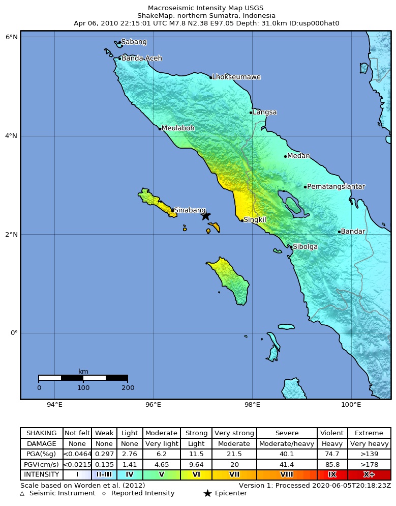
The USGS ShakeMap: shaking estimated from seismic stations and the quake’s size, on the Modified Mercalli intensity scale.
- Strongest estimated
- VII, very strong shaking
- Peak ground acceleration
- 29.4% of gravity
- Peak ground velocity
- 3.4 cm/s
- Map
- Automatic
Did you feel it?
No one has reported feeling this quake to the USGS.
Fault motion and ground failure
How the rock slipped, from the moment tensor, and the USGS estimate of landslides and liquefaction.
- Faulting
- Reverse (thrust)
- Moment magnitude
- 7.7 Mww
- Nodal plane 1
- Strike 315°, dip 9°, rake 97°
- Nodal plane 2
- Strike 127°, dip 80°, rake 88°
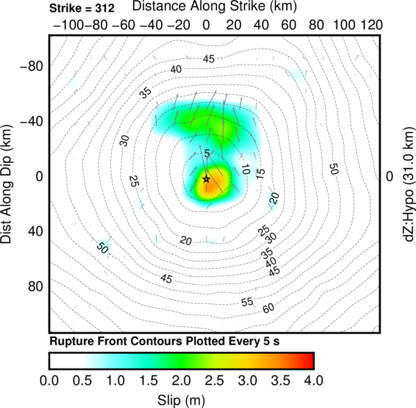
Rupture model
How far the rock on each part of the fault slid, from a model fitted to seismic waves recorded around the world.
Tectonic setting
Why earthquakes happen here, from the USGS tectonic summary.
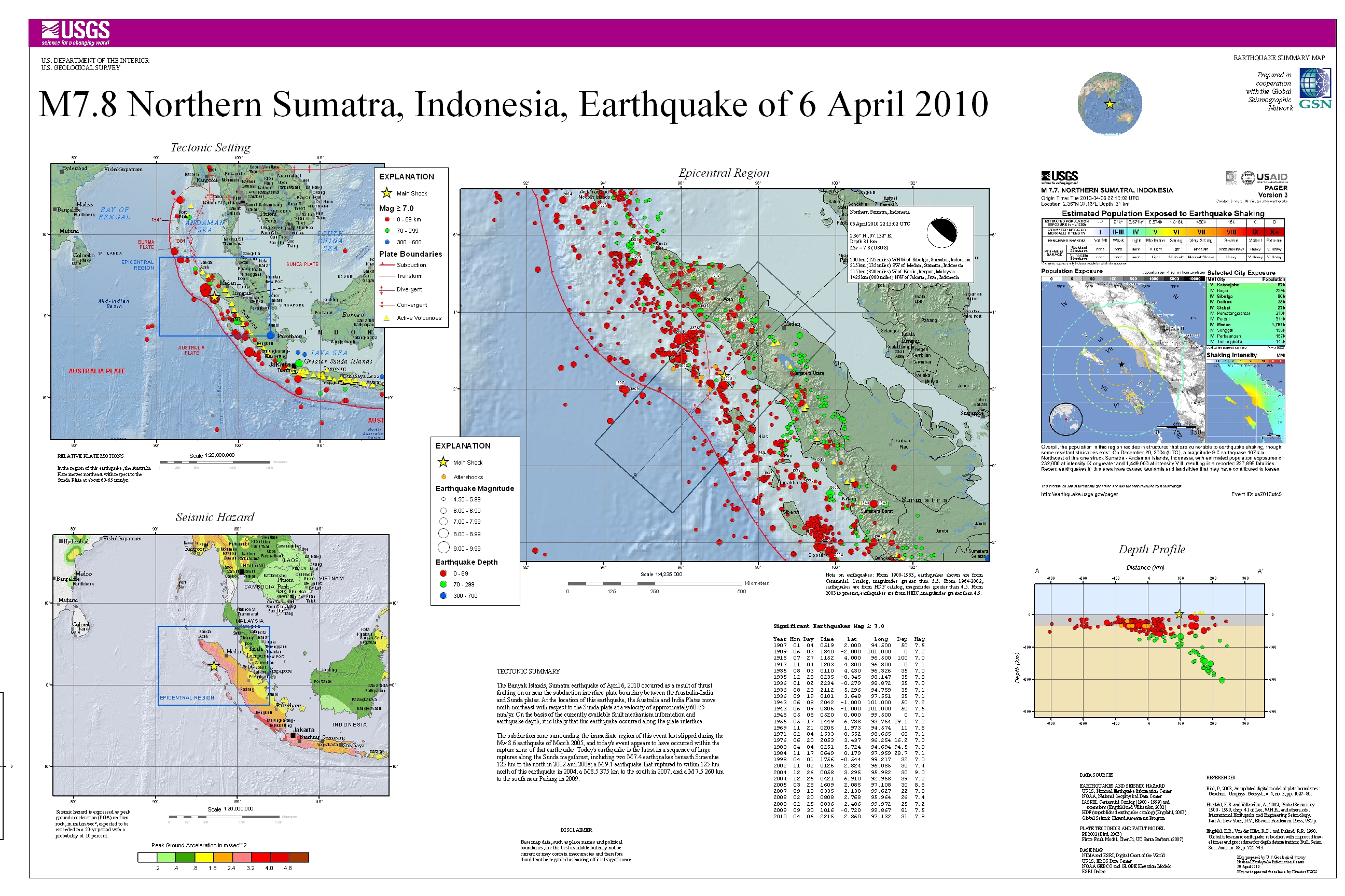
The April 6, 2010, M 7.8 northern Sumatra earthquake occurred as the result of shallow thrust faulting on or near the subduction interface plate boundary between the Indo-Australia and Sunda plates. At the location of this earthquake, the Australia and India plates move north-northeast relative to the Sunda plate at a velocity of about 60–65 mm/yr. On the basis of the currently available faulting mechanism information and earthquake depth, this earthquake likely occurred along the subduction interface.
While commonly plotted as points on maps, earthquakes of this size are more appropriately described as slip over a larger fault area. Thrust-faulting events of the size of the April 6, 2010, earthquake are typically about 120x50 km (length x width); modeling of this earthquake implies dimensions of about 80x60 km, predominantly surrounding and up-dip of the hypocenter.
The subduction zone surrounding the immediate region of this event last slipped during the M 8.6 earthquake of March 2005, and the April 6th event appears to have occurred within the rupture zone of that earthquake. The April 6th earthquake is the latest in a sequence of large ruptures along the Sunda megathrust, two M 7.4 earthquakes beneath Simeulue 125 km to the north in 2002 and 2008; a M 9.1 earthquake ruptured to within 125 km north of this earthquake in 2004; a M 8.5 earthquake broke the plate boundary 375 km to the south in 2007; and a M 7.6 earthquake 260 km to the south near Padang in 2009.
Hayes et al. (2016) Tectonic summaries of magnitude 7 and greater earthquakes from 2000 to 2015, USGS Open-File Report 2016-1192. (5.2 MB PDF)
From the USGS event page for usp000hat0. U.S. Geological Survey text and figures are in the public domain.
USGS summary poster
How well it is located
Reviewed by a seismologist.
- Depth from
- OPERATOR_ASSIGNED
- Station coverage gap
- 19°
- Stations used
- 352
Nearest places
Distance and direction from each place to the epicenter, with its forecast.
Nearby
Within 100 km, magnitude 4.8 and up: 5 in the 60 days after this one and 0 in the 30 days before it.
After
- 5.369 km W of Singkil, Indonesia · 6022 days ago · 35 km deep · 14 km away · felt by 5
- 5.173 km SSE of Sinabang, Indonesia · 6022 days ago · 28 km deep · 64 km away · felt by 4
- 5.163 km ENE of Sinabang, Indonesia · 6022 days ago · 35 km deep · 31 km away
- 4.828 km SSE of Sinabang, Indonesia · 6021 days ago · 35 km deep · 63 km away
- 5.065 km W of Singkil, Indonesia · 6016 days ago · 57 km deep · 17 km away
Earthquakes todayIndonesia earthquakesLive radar here
Sources
From the USGS Earthquake Hazards Program and its partner networks, event usp000hat0 (also filed as choy20100406221501, gcmtm201004062215a, duputel201004062215a, gcmt20100406221501, atlas20100406221501, iscgem600296664). Read Thu, Oct 1, 2026, 5:05 PM UTC.