M6.4 earthquake 15 km ESE of Várda, Greece
A magnitude 6.4 earthquake struck 15 km ESE of Várda, Greece on Sun, Jun 8, 2008, 3:25 PM GMT+3 (12:25 UTC), 16 km (10 mi) below the surface.
Map
Where this earthquake was located, with the others nearby. Select one for its page.
The earthquake
- Magnitude
- 6.4 (Mwc, centroid moment), strong
- Magnitude from
- USGS National Earthquake Information Center
- Local time
- UTC
- 2008-06-08 12:25:29 UTC
- Depth
- 16.0 km (9.9 mi), shallow
- Epicenter
- 37.963° N, 21.525° E
- Region
- Greece
- Felt reports
- 451
- Strongest shaking
- VIII, severe shaking
- Tsunami flag
- No
- Status
- Reviewed by a seismologist
Magnitude estimates
Different scales measure different things and differ by a few tenths. The USGS marks one as preferred, and it is the one this page uses.
| Mag. | Scale | Computed by | Notes |
|---|---|---|---|
| 6.4 | Mwc, centroid moment | USGS National Earthquake Information Center | Preferred · Reviewed |
| 6.38 | Mw, moment | ISC-GEM global catalog | Final · ±0.1 |
| 6.4 | Mwc, centroid moment | Global CMT project | Preliminary |
| 6.93 | Me, energy | Choy, USGS energy magnitude | Reviewed |
Deaths and damage
From NOAA NCEI’s Significant Earthquake Database (record 7925), matched to this event by time and place.
- Deaths
- 2
- Injuries
- 240
- Damage
- Severe (about $5 to $25 million)
- Houses destroyed
- 1,156
Where the literature gives no number, NCEI records a description on a scale of 1 to 4, printed here in its words. Damage is in millions of US dollars of the year of the event, not adjusted for inflation.
From Wikipedia
The 2008 Peloponnese earthquake killed two people, injured more than 220 and left at least 2,000 people homeless in north western Peloponnese, Greece, on June 8. The earthquake hit the area at 1525 EET (1325 UTC), with a moment magnitude of 6.5, according to the Athens Geodynamic Institute. It was strongly felt as far away as in Athens and in parts of southern Italy. The US Geological Survey reported that the quake had a magnitude of 6.4. The epicenter of the tremor was located about 15 miles (32 km) southwest of the Greek port city of Patras, at a depth of 16 km. Interior Minister Prokopis Pavlopoulos dispatched rescue and recovery teams (including members of five government agencies), the Red Cross and units of the army in order to assess the damage and the needs of survivors in the earthquake affected areas.
Text from Wikipedia, “2008 Peloponnese earthquake”, licensed CC BY-SA 4.0. Quoted as written; the full article has the rest.
The article is about the earthquake NOAA’s record describes, matched to this one by date, place and magnitude.
What happened
The USGS’s account of the effects of this earthquake.
Two people killed, at least 240 injured and at least 1,156 buildings damaged or destroyed in Achaia and Ileia. Felt (VIII) at Kato Achaia; (VII) at Patrai and Rion; (VI) at Agrinion; (V) at Corinth, Tripolis and Zakynthos; (IV) at Agia Paraskevi, Aigina, Argostolion, Athens, Ioannina, Kallithea, Karditsa, Kifisia, Nydri, Preveza, Trikala and Volos; (III) at Amarousion, Galatsion, Glifadha, Kalamakion, Khalandrion, Larisa, Nea Erithraia, Nea Ionia, Nea Smirni, Nikaia, Palaion Faliron and Piraeus; (II) at Aigaleo, Chani, Korydallos and Voula. Felt in most parts of Greece. Also felt at Tirana, Albania; Barletta, Brindisi, Cosenza, Lecce, Matera, Naples and Taranto, Italy; Ohrid, Macedonia.
From the USGS event page for usp000g8vs. U.S. Geological Survey text and figures are in the public domain.
Shaking
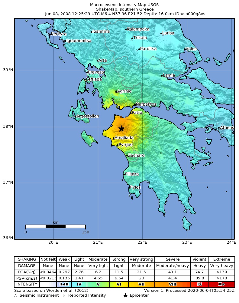
The USGS ShakeMap: shaking estimated from seismic stations and the quake’s size, on the Modified Mercalli intensity scale.
- Strongest estimated
- VIII, severe shaking
- Peak ground acceleration
- 41.2% of gravity
- Peak ground velocity
- 3.7 cm/s
- Map
- Automatic
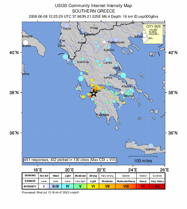
Did you feel it?
451 people reported to the USGS what they felt; the strongest reported shaking was VIII, severe shaking.
Fault motion and ground failure
How the rock slipped, from the moment tensor, and the USGS estimate of landslides and liquefaction.
- Faulting
- Strike-slip
- Nodal plane 1
- Strike 301°, dip 74°, rake 7°
- Nodal plane 2
- Strike 209°, dip 83°, rake 164°
- Landslide alert
- Yellow
- Liquefaction alert
- Yellow
Tectonic setting
Why earthquakes happen here, from the USGS tectonic summary.
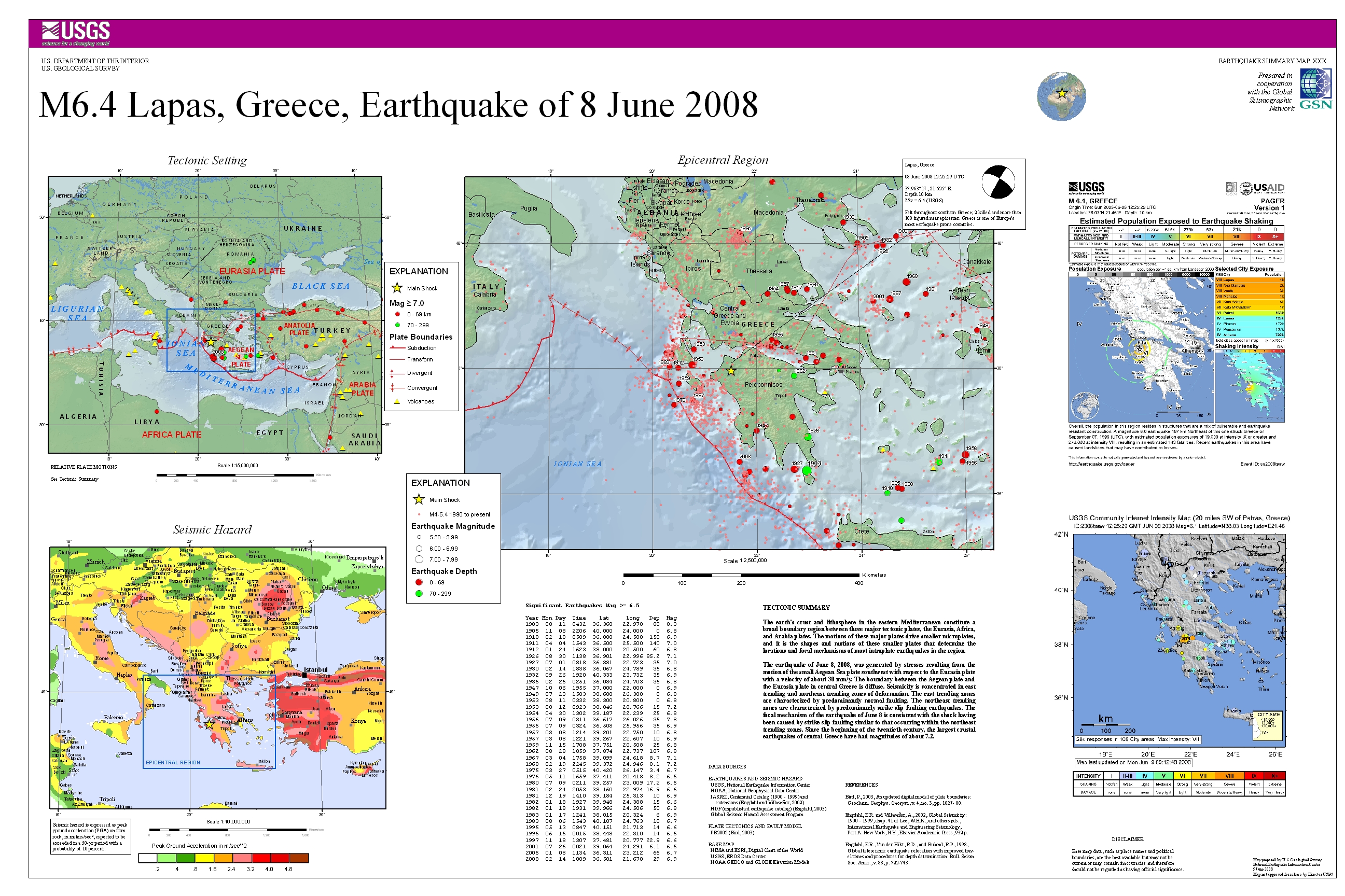
The earth's crust and lithosphere in the eastern Mediterranean constitute a broad boundary region between three major tectonic plates, the Eurasia, Africa, and Arabia plates. The motions of these major plates drive smaller microplates, and it is the shapes and motions of these smaller plates that determine the locations and focal mechanisms of most intraplate earthquakes in the region.
The earthquake of June 8, 2008, was generated by stresses resulting from the motion of the small Aegean Sea plate southwest with respect to the Eurasia plate with a velocity of about 30 mm/y. The boundary between the Aegean plate and the Eurasia plate in central Greece is diffuse. Seismicity is concentrated in east-trending and northeast-trending zones of deformation. The east-trending zones are characterized by predominantly normal faulting. The northeast-trending zones are characterized by predominately strike-slip faulting earthquakes. The focal-mechanism of the earthquake of June 8 is consistent with the shock having been caused by strike-slip faulting similar to that occurring within the northeast-trending zones. Since the beginning of the twentieth century, the largest crustal earthquakes of central Greece have had magnitudes of about 7.2.
From the USGS event page for usp000g8vs. U.S. Geological Survey text and figures are in the public domain.
USGS summary poster
How well it is located
Reviewed by a seismologist.
- Depth from
- OPERATOR_ASSIGNED
- Station coverage gap
- 26°
- Stations used
- 706
Nearest places
Distance and direction from each place to the epicenter, with its forecast.
Nearby
Within 100 km, magnitude 3.4 and up: 80 in the 60 days after this one and 15 in the 30 days before it.
After
- 3.64 km WSW of Káto Mazaráki, Greece · 6690 days ago · 28 km deep · 13 km away
- 3.85 km S of Káto Acha?a, Greece · 6690 days ago · 19 km deep · 15 km away
- 4.110 km SSW of Káto Mazaráki, Greece · 6690 days ago · 15 km deep · 7 km away
- 3.64 km NE of Synoikismós Chavaríou, Greece · 6690 days ago · 15 km deep · 12 km away
- 3.43 km NNW of Káto Mazaráki, Greece · 6690 days ago · 10 km deep · 18 km away
- 3.410 km SSE of Limnokhórion, Greece · 6690 days ago · 21 km deep · 11 km away
- 3.56 km WNW of Káto Mazaráki, Greece · 6690 days ago · 21 km deep · 16 km away
- 3.411 km SW of Káto Mazaráki, Greece · 6690 days ago · 20 km deep · 5 km away
- 4.013 km ESE of Várda, Greece · 6690 days ago · 27 km deep · 2 km away
- 3.57 km WSW of Káto Mazaráki, Greece · 6690 days ago · 20 km deep · 10 km away
- 3.911 km ESE of Néa Manoláda, Greece · 6690 days ago · 26 km deep · 5 km away
- 3.89 km SW of Káto Mazaráki, Greece · 6690 days ago · 16 km deep · 7 km away
- 4.09 km WSW of Káto Mazaráki, Greece · 6690 days ago · 16 km deep · 10 km away
- 4.313 km SW of Káto Mazaráki, Greece · 6690 days ago · 18 km deep · 3 km away
- 4.09 km ESE of Lápas, Greece · 6690 days ago · 20 km deep · 11 km away
- 3.49 km ESE of Várda, Greece · 6689 days ago · 5 km deep · 7 km away
- 3.69 km NNE of Langádhia, Greece · 6689 days ago · 10 km deep · 52 km away
- 3.611 km ESE of Néa Manoláda, Greece · 6689 days ago · 23 km deep · 5 km away
- 3.515 km ESE of Várda, Greece · 6689 days ago · 27 km deep · 1 km away
- 4.012 km SE of Lápas, Greece · 6689 days ago · 19 km deep · 6 km away
- 3.412 km ESE of Néa Manoláda, Greece · 6689 days ago · 14 km deep · 4 km away
- 3.48 km S of Káto Acha?a, Greece · 6689 days ago · 20 km deep · 12 km away
- 3.5southern Greece · 6689 days ago · 19 km deep · 7 km away
- 3.59 km E of Synoikismós Chavaríou, Greece · 6689 days ago · 16 km deep · 11 km away
- 3.59 km SE of Lápas, Greece · 6689 days ago · 28 km deep · 9 km away
- 3.42 km ESE of Káto Acha?a, Greece · 6689 days ago · 22 km deep · 20 km away
- 3.411 km NE of Synoikismós Chavaríou, Greece · 6689 days ago · 19 km deep · 6 km away
- 3.510 km SE of Lápas, Greece · 6688 days ago · 18 km deep · 9 km away
- 3.59 km SW of Káto Mazaráki, Greece · 6687 days ago · 24 km deep · 7 km away
- 3.67 km SW of Káto Mazaráki, Greece · 6687 days ago · 25 km deep · 9 km away
- 3.48 km ESE of Néa Manoláda, Greece · 6687 days ago · 22 km deep · 8 km away
- 3.65 km SE of Limnokhórion, Greece · 6686 days ago · 16 km deep · 15 km away
- 3.48 km NE of Synoikismós Chavaríou, Greece · 6686 days ago · 22 km deep · 9 km away
- 3.415 km SW of Káto Mazaráki, Greece · 6686 days ago · 13 km deep · 1 km away
- 3.44 km SW of Vrachnaíika, Greece · 6686 days ago · 21 km deep · 22 km away
- 3.49 km NNE of Synoikismós Chavaríou, Greece · 6684 days ago · 17 km deep · 8 km away
- 3.48 km WSW of Káto Mazaráki, Greece · 6683 days ago · 16 km deep · 10 km away
- 3.613 km NW of Sámi, Greece · 6683 days ago · 7 km deep · 95 km away
- 3.42 km N of Synoikismós Chavaríou, Greece · 6683 days ago · 20 km deep · 15 km away
- 3.42 km NW of Káto Mazaráki, Greece · 6682 days ago · 29 km deep · 17 km away
- 3.412 km N of Kamárai, Greece · 6680 days ago · 17 km deep · 66 km away
- 3.411 km NE of Synoikismós Chavaríou, Greece · 6680 days ago · 24 km deep · 5 km away
- 3.43 km N of Amaliáda, Greece · 6680 days ago · 15 km deep · 21 km away
- 3.49 km W of Káto Mazaráki, Greece · 6679 days ago · 26 km deep · 11 km away
- 3.513 km ENE of Chalandrítsa, Greece · 6678 days ago · 59 km deep · 41 km away
- 3.515 km NNE of Goúmero, Greece · 6677 days ago · 22 km deep · 14 km away
- 3.43 km ESE of Chávari, Greece · 6676 days ago · 24 km deep · 16 km away
- 4.05 km WNW of Vrachnaíika, Greece · 6674 days ago · 5 km deep · 25 km away
- 3.56 km W of Káto Mazaráki, Greece · 6674 days ago · 15 km deep · 12 km away
- 3.99 km SSE of Limnokhórion, Greece · 6673 days ago · 20 km deep · 11 km away
- 3.413 km ENE of Synoikismós Chavaríou, Greece · 6673 days ago · 20 km deep · 5 km away
- 3.64 km ESE of Káto Acha?a, Greece · 6673 days ago · 18 km deep · 19 km away
- 3.58 km NW of Kamárai, Greece · 6672 days ago · 5 km deep · 55 km away
- 4.210 km WSW of Káto Mazaráki, Greece · 6672 days ago · 14 km deep · 7 km away
- 3.43 km SE of Kardamás, Greece · 6669 days ago · 16 km deep · 27 km away
- 3.48 km NW of Royítika, Greece · 6667 days ago · 12 km deep · 31 km away
- 3.414 km NE of Synoikismós Chavaríou, Greece · 6666 days ago · 25 km deep · 3 km away
- 4.01 km NE of Antirrio, Greece · 6666 days ago · 13 km deep · 47 km away
- 3.411 km NNE of Arfará, Greece · 6666 days ago · 9 km deep · 94 km away
- 3.47 km SW of Káto Mazaráki, Greece · 6665 days ago · 26 km deep · 9 km away
The first 60 of 80.
Before
- 3.52 km ENE of Náfpaktos, Greece · 6691 days ago · 12 km deep · 56 km away
- 3.53 km W of Galaxídhion, Greece · 6692 days ago · 25 km deep · 85 km away
- 3.46 km SSE of Náfpaktos, Greece · 6693 days ago · 13 km deep · 51 km away
- 3.85 km N of Megalópoli, Greece · 6693 days ago · 71 km deep · 79 km away
- 3.410 km WSW of Kalávryta, Greece · 6693 days ago · 17 km deep · 43 km away
- 4.310 km NNE of Lixoúri, Greece · 6693 days ago · 17 km deep · 97 km away
- 3.52 km NNW of Lixoúri, Greece · 6693 days ago · 18 km deep · 100 km away
- 3.715 km NW of Sámi, Greece · 6694 days ago · 6 km deep · 97 km away
- 3.513 km NNE of Lixoúri, Greece · 6694 days ago · 15 km deep · 98 km away
- 3.44 km ESE of Lithakiá, Greece · 6706 days ago · 11 km deep · 65 km away
- 3.6Greece · 6707 days ago · 6 km deep · 20 km away
- 3.48 km SSW of Argostólion, Greece · 6708 days ago · 13 km deep · 96 km away
- 3.62 km WSW of Sámi, Greece · 6711 days ago · 14 km deep · 85 km away
- 3.55 km SW of Thérmo, Greece · 6717 days ago · 44 km deep · 65 km away
- 3.518 km SW of Lithakiá, Greece · 6720 days ago · 19 km deep · 84 km away
Earthquakes todayGreece earthquakesLive radar here
Sources
From the USGS Earthquake Hazards Program and its partner networks, event usp000g8vs (also filed as us2008taaw, choy20080608122529, gcmtc200806081225a, gcmt20080608122529, atlas20080608122530, iscgem13231364). Read Fri, Oct 2, 2026, 9:49 PM UTC.