M6.4 earthquake 35 km SSW of Lárdos, Greece
A magnitude 6.4 earthquake struck 35 km SSW of Lárdos, Greece on Tue, Jul 15, 2008, 6:26 AM GMT+3 (03:26 UTC), 52 km (32 mi) below the surface.
Map
Where this earthquake was located, with the others nearby. Select one for its page.
The earthquake
- Magnitude
- 6.4 (Mwc, centroid moment), strong
- Magnitude from
- USGS National Earthquake Information Center
- Local time
- UTC
- 2008-07-15 03:26:34 UTC
- Depth
- 52.0 km (32.3 mi), shallow
- Epicenter
- 35.800° N, 27.860° E
- Region
- Greece
- Felt reports
- 231
- Strongest shaking
- VI, strong shaking
- Tsunami flag
- No
- Status
- Reviewed by a seismologist
Magnitude estimates
Different scales measure different things and differ by a few tenths. The USGS marks one as preferred, and it is the one this page uses.
| Mag. | Scale | Computed by | Notes |
|---|---|---|---|
| 6.4 | Mwc, centroid moment | USGS National Earthquake Information Center | Preferred · Reviewed |
| 6.4 | Mw, moment | ISC-GEM global catalog | Final · ±0.1 |
| 6.4 | Mwc, centroid moment | Global CMT project | Preliminary |
| 6.75 | Me, energy | Choy, USGS energy magnitude | Reviewed |
What happened
The USGS’s account of the effects of this earthquake.
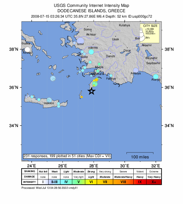
One person killed on Rhodes. Felt (VII) at Trianta, (VI) at Lardos, (V) at Rodos and (III) at Iraklion and Kos. Also felt at Afantou, Antimacheia, Ayios Nikolaos, Chania, Gazion, Ierapetra, Kallithea, Karpathos, Kissamos, Kolimvarion, Kremasti, Masari, Neapolis, Oia, Rethymnon, Soroni, Thira and on Simi. Felt (V) at Marmaris, (IV) at Alanya and Bodrum and (III) at Fethiye, Turkey. Also felt at Antalya, Aydin, Izmir, Kusadasi, Milas, Mugla, Soke and Urla. Felt (III) at Paphos and (II) at Limassol, Cyprus. Also felt at Kyrenia, Nicosia and Polis. Felt (III) at Alexandria, Al Jizah and Cairo, Egypt. Also felt at Al Maks, Az Zaqaziq, Damanhur, Fa'id and Tanta. Felt at Kefar Sava, Haifa and Ramat Gan, Israel; at Beirut, Lebanon; at Ramallah, West Bank and at Damascus, Syria.
From the USGS event page for usp000gc72. U.S. Geological Survey text and figures are in the public domain.
Shaking
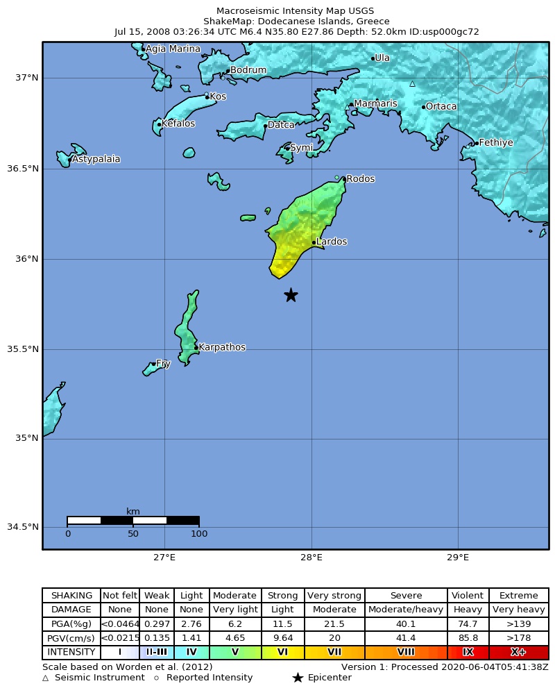
The USGS ShakeMap: shaking estimated from seismic stations and the quake’s size, on the Modified Mercalli intensity scale.
- Strongest estimated
- VI, strong shaking
- Peak ground acceleration
- 15.6% of gravity
- Peak ground velocity
- 2.3 cm/s
- Map
- Automatic
Did you feel it?
231 people reported to the USGS what they felt; the strongest reported shaking was VII, very strong shaking.
Fault motion and ground failure
How the rock slipped, from the moment tensor, and the USGS estimate of landslides and liquefaction.
- Faulting
- Strike-slip
- Nodal plane 1
- Strike 357°, dip 55°, rake -169°
- Nodal plane 2
- Strike 261°, dip 81°, rake -36°
How well it is located
Reviewed by a seismologist.
- Depth from
- OPERATOR_ASSIGNED
- Station coverage gap
- 19°
- Stations used
- 774
Nearest places
Distance and direction from each place to the epicenter, with its forecast.
Nearby
Within 100 km, magnitude 3.4 and up: 27 in the 60 days after this one and 13 in the 30 days before it.
After
- 3.757 km ESE of Karpathos, Greece · 6653 days ago · 30 km deep · 47 km away
- 3.758 km SSW of Lárdos, Greece · 6653 days ago · 30 km deep · 24 km away
- 3.652 km ENE of Karpathos, Greece · 6653 days ago · 12 km deep · 19 km away
- 3.434 km SW of Lárdos, Greece · 6653 days ago · 55 km deep · 14 km away
- 3.417 km WNW of Karpathos, Greece · 6653 days ago · 27 km deep · 78 km away
- 3.536 km WSW of Lárdos, Greece · 6653 days ago · 39 km deep · 22 km away
- 4.926 km SSW of Lárdos, Greece · 6653 days ago · 58 km deep · 9 km away
- 3.928 km SSW of Lárdos, Greece · 6653 days ago · 59 km deep · 7 km away
- 3.639 km ESE of Karpathos, Greece · 6652 days ago · 21 km deep · 47 km away
- 3.46 km S of Fry, Greece · 6652 days ago · 20 km deep · 98 km away
- 3.635 km SW of Lárdos, Greece · 6652 days ago · 49 km deep · 18 km away
- 3.536 km SSW of Lárdos, Greece · 6651 days ago · 43 km deep · 5 km away
- 3.536 km WSW of Lárdos, Greece · 6651 days ago · 47 km deep · 22 km away
- 3.456 km S of Lárdos, Greece · 6651 days ago · 32 km deep · 24 km away
- 3.733 km SSW of Lárdos, Greece · 6651 days ago · 51 km deep · 6 km away
- 3.422 km ENE of Karpathos, Greece · 6645 days ago · 38 km deep · 46 km away
- 3.827 km SSW of Lárdos, Greece · 6643 days ago · 53 km deep · 9 km away
- 3.412 km NNE of Karpathos, Greece · 6621 days ago · 19 km deep · 58 km away
- 3.532 km SE of Fry, Greece · 6620 days ago · 5 km deep · 92 km away
- 4.324 km SSW of Lárdos, Greece · 6618 days ago · 54 km deep · 12 km away
- 3.525 km S of Mandráki, Greece · 6617 days ago · 32 km deep · 96 km away
- 3.525 km S of Mandráki, Greece · 6616 days ago · 36 km deep · 95 km away
- 3.428 km SW of Émponas, Greece · 6613 days ago · 26 km deep · 35 km away
- 4.015 km WNW of Émponas, Greece · 6610 days ago · 68 km deep · 57 km away
- 3.535 km SW of Lárdos, Greece · 6609 days ago · 47 km deep · 12 km away
- 3.436 km ESE of Karpathos, Greece · 6608 days ago · 19 km deep · 48 km away
- 3.455 km ESE of Karpathos, Greece · 6602 days ago · 14 km deep · 52 km away
Before
- 3.618 km NW of Karpathos, Greece · 6654 days ago · 26 km deep · 73 km away
- 4.42 km SSW of Karpathos, Greece · 6654 days ago · 34 km deep · 69 km away
- 3.712 km N of Karpathos, Greece · 6680 days ago · 18 km deep · 63 km away
- 3.49 km N of Karpathos, Greece · 6680 days ago · 20 km deep · 62 km away
- 4.57 km NE of Karpathos, Greece · 6680 days ago · 22 km deep · 60 km away
- 3.47 km N of Karpathos, Greece · 6680 days ago · 20 km deep · 63 km away
- 3.68 km NNE of Karpathos, Greece · 6680 days ago · 22 km deep · 60 km away
- 3.44 km E of Karpathos, Greece · 6680 days ago · 21 km deep · 64 km away
- 4.26 km NNE of Karpathos, Greece · 6680 days ago · 10 km deep · 61 km away
- 3.43 km N of Karpathos, Greece · 6681 days ago · 21 km deep · 65 km away
- 3.744 km N of Karpathos, Greece · 6681 days ago · 5 km deep · 60 km away
- 3.89 km N of Karpathos, Greece · 6681 days ago · 19 km deep · 61 km away
- 3.445 km SSE of Karpathos, Greece · 6683 days ago · 21 km deep · 81 km away
Earthquakes todayGreece earthquakesLive radar here
Sources
From the USGS Earthquake Hazards Program and its partner networks, event usp000gc72 (also filed as us2008umai, choy20080715032634, gcmtc200807150326a, gcmt20080715032634, atlas20080715032634, iscgem13389231). Read Fri, Oct 2, 2026, 2:04 PM UTC.