M3.3 earthquake 48 km WNW of Granite Falls, Washington
A magnitude 3.3 earthquake struck 48 km WNW of Granite Falls, Washington on Mon, Mar 17, 2008, 4:58 PM PDT (23:58 UTC), 0 km (0 mi) below the surface.
A larger quake followed: M3.4 12 km E of Verlot, Washington. This one was a foreshock.
Map
Where this earthquake was located, with the others nearby. Select one for its page.
The earthquake
- Magnitude
- 3.3 (Md, duration), minor
- Magnitude from
- Pacific Northwest Seismic Network
- Local time
- UTC
- 2008-03-17 23:58:48 UTC
- Depth
- -0.5 km (-0.3 mi), shallow
- Epicenter
- 48.070° N, 120.810° W
- Region
- Washington
- Strongest shaking
- IV, light shaking
- Tsunami flag
- No
- Status
- Reviewed by a seismologist
Magnitude estimates
Different scales measure different things and differ by a few tenths. The USGS marks one as preferred, and it is the one this page uses.
| Mag. | Scale | Computed by | Notes |
|---|---|---|---|
| 3.3 | Md, duration | Pacific Northwest Seismic Network | Preferred · Final · ±0.07 · 6 stations |
| 3.3 | Md, duration | USGS National Earthquake Information Center | Reviewed |
What happened
The USGS’s account of the effects of this earthquake.
no people dead or missing; no people injured; no buildings damaged or destroyed
From the USGS event page for uw10738818. U.S. Geological Survey text and figures are in the public domain.
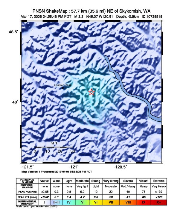
Shaking
The USGS ShakeMap: shaking estimated from seismic stations and the quake’s size, on the Modified Mercalli intensity scale.
- Strongest estimated
- IV, light shaking
- Map
- Automatic
Did you feel it?
No one has reported feeling this quake to the USGS.
How well it is located
Reviewed by a seismologist.
- Location uncertainty
- About 1.6 km horizontally, 14.8 km in depth
- Magnitude uncertainty
- ±0.07
- Depth from
- Operator assigned
- Station coverage gap
- 39°
- Stations used
- 41
Nearest places
Distance and direction from each place to the epicenter, with its forecast.
Nearby
Within 100 km, magnitude 1.5 and up: 16 in the 60 days after this one and 4 in the 30 days before it.
After
- 2.048 km WNW of Granite Falls, Washington · 6775 days ago · 4 km deep · 1 km away
- 2.612 km NW of Conconully, Washington · 6763 days ago · -1 km deep · 95 km away
- 1.75 km SE of Oso, Washington · 6756 days ago · 10 km deep · 81 km away
- 2.011 km NNE of Marblemount, Washington · 6753 days ago · 1 km deep · 74 km away
- 2.513 km W of Entiat, Washington · 6752 days ago · -1 km deep · 54 km away
- 1.65 km NNW of Swede Heaven, Washington · 6749 days ago · 3 km deep · 75 km away
- 2.711 km E of Verlot, Washington · 6748 days ago · -1 km deep · 60 km away
- 1.67 km NNE of Lake Marcel-Stillwater, Washington · 6741 days ago · 3 km deep · 86 km away
- 2.3Washington · 6740 days ago · 0 km deep · 60 km away
- 3.412 km E of Verlot, Washington · 6740 days ago · 0 km deep · 59 km away
- 1.79 km SW of Entiat, Washington · 6738 days ago · 5 km deep · 64 km away
- 1.86 km SSE of Sultan, Washington · 6736 days ago · -1 km deep · 78 km away
- 1.54 km NE of Fall City, Washington · 6730 days ago · 16 km deep · 94 km away
- 1.66 km W of Entiat, Washington · 6730 days ago · -1 km deep · 59 km away
- 1.86 km N of Waterville, Washington · 6720 days ago · 3 km deep · 68 km away
- 1.59 km NE of Chelan Falls, Washington · 6715 days ago · 0 km deep · 73 km away
Before
- 1.58 km E of Lake Marcel-Stillwater, Washington · 6783 days ago · 21 km deep · 85 km away
- 1.837 km NNW of Leavenworth, Washington · 6786 days ago · 6 km deep · 17 km away
- 1.75 km N of Woods Creek, Washington · 6792 days ago · 15 km deep · 82 km away
- 2.00 km NW of Lake Marcel-Stillwater, Washington · 6798 days ago · 25 km deep · 93 km away
Earthquakes todayWashington earthquakesLive radar here
Sources
From the USGS Earthquake Hazards Program and its partner networks, event uw10738818 (also filed as usp000g1q6). Read Sun, Oct 4, 2026, 2:57 PM UTC.