M3.6 earthquake 8 km NW of Brooks, Oregon
A magnitude 3.6 earthquake struck 8 km NW of Brooks, Oregon on Sun, Sep 23, 2007, 11:20 PM PDT (06:20 UTC), 23 km (15 mi) below the surface.
Map
Where this earthquake was located, with the others nearby. Select one for its page.
The earthquake
- Magnitude
- 3.6 (Md, duration), minor
- Magnitude from
- Pacific Northwest Seismic Network
- Local time
- UTC
- 2007-09-24 06:20:54 UTC
- Depth
- 23.4 km (14.6 mi), shallow
- Epicenter
- 45.103° N, 123.030° W
- Region
- Oregon
- Felt reports
- 1,634
- Tsunami flag
- No
- Status
- Reviewed by a seismologist
Magnitude estimates
Different scales measure different things and differ by a few tenths. The USGS marks one as preferred, and it is the one this page uses.
| Mag. | Scale | Computed by | Notes |
|---|---|---|---|
| 3.6 | Md, duration | Pacific Northwest Seismic Network | Preferred · Final · ±0.03 · 25 stations |
| 3.6 | ML, local (Richter) | USGS National Earthquake Information Center | Reviewed |
What happened
The USGS’s account of the effects of this earthquake.
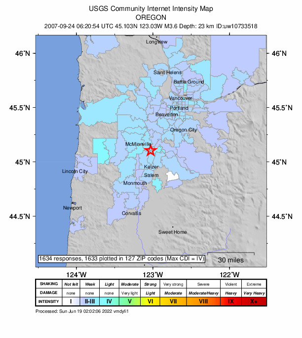
Felt (IV) at Gervais; (III) at Amity, Aurora, Canby, Carlton, Clackamas, Dallas, Dayton, Dundee, Fairview, Forest Grove, Gladstone, Lafayette, Lake Oswego, McMinnville, Monmouth, Portland, Saint Helens, Salem, Sherwood, Silverton, Troutdale, Willamina, Wilsonville and Yamhill; (II) at Beaverton, Corvallis, Estacada, Gresham, Hillsboro, Lincoln City, Molalla, Mount Angel, Newberg, Oregon City, Sheridan, Tualatin, West Linn and Woodburn. Also felt at Albany, Astoria, Banks, Coos Bay, Corbett, Cornelius, Gaston, Grand Ronde, Independence, Mulino, North Plains, Otis, Philomath, Rickreall, Saint Paul, Sandy, Scappoose, Scotts Mills, Stayton, Tillamook, Turner and Waldport. Felt (III) at Vancouver and Washougal; (II) at Battle Ground, Brush Prairie, Camas, Kelso, La Center, Ridgefield and Stevenson, Washington. Also felt at Carson, Friday Harbor, Kalama, Seattle, Woodland and Yacolt.
From the USGS event page for uw10733518. U.S. Geological Survey text and figures are in the public domain.
Did you feel it?
1,634 people reported to the USGS what they felt; the strongest reported shaking was IV, light shaking.
Fault motion and ground failure
How the rock slipped, from the moment tensor, and the USGS estimate of landslides and liquefaction.
- Faulting
- Oblique normal
- Nodal plane 1
- Strike 125°, dip 90°, rake -45°
- Nodal plane 2
- Strike 215°, dip 45°, rake -180°
How well it is located
Reviewed by a seismologist.
- Location uncertainty
- About 0.4 km horizontally, 0.7 km in depth
- Magnitude uncertainty
- ±0.03
- Depth from
- From location
- Station coverage gap
- 49°
- Stations used
- 56
Nearest places
Distance and direction from each place to the epicenter, with its forecast.
Nearby
Within 100 km, magnitude 1.5 and up: 5 in the 60 days after this one and 3 in the 30 days before it.
After
- 1.58 km NW of Brooks, Oregon · 6944 days ago · 23 km deep · 1 km away
- 1.57 km E of Scotts Mills, Oregon · 6933 days ago · 17 km deep · 36 km away
- 1.95 km N of Rickreall, Oregon · 6931 days ago · 26 km deep · 21 km away
- 2.11 km WNW of Columbia City, Oregon · 6921 days ago · 24 km deep · 89 km away
- 1.92 km E of Hockinson, Washington · 6893 days ago · 8 km deep · 84 km away
Before
Earthquakes todayOregon earthquakesLive radar here
Sources
From the USGS Earthquake Hazards Program and its partner networks, event uw10733518 (also filed as usp000fp0b, uw09240620). Read Sun, Oct 4, 2026, 9:47 AM UTC.