M7.6 earthquake 196 km S of Ambon, Indonesia
A magnitude 7.6 earthquake struck 196 km S of Ambon, Indonesia on Sat, Jan 28, 2006, 1:58 AM GMT+9 (16:58 UTC), 397 km (247 mi) below the surface.
Map
Where this earthquake was located, with the others nearby. Select one for its page.
The earthquake
- Magnitude
- 7.6 (Mwc, centroid moment), major
- Magnitude from
- USGS National Earthquake Information Center
- Local time
- UTC
- 2006-01-27 16:58:53 UTC
- Depth
- 397.0 km (246.7 mi), deep
- Epicenter
- 5.473° S, 128.131° E
- Region
- Indonesia
- Felt reports
- 74
- Tsunami flag
- No
- Status
- Reviewed by a seismologist
Magnitude estimates
Different scales measure different things and differ by a few tenths. The USGS marks one as preferred, and it is the one this page uses.
| Mag. | Scale | Computed by | Notes |
|---|---|---|---|
| 7.6 | Mwc, centroid moment | USGS National Earthquake Information Center | Preferred · Reviewed |
| 7.64 | Mw, moment | ISC-GEM global catalog | Final · ±0.1 |
| 7.6 | Mwc, centroid moment | Global CMT project | Preliminary |
| 7.47 | Me, energy | Choy, USGS energy magnitude | Reviewed |
| 7.7 | Mww, W-phase moment | Duputel, W-phase inversion | Preliminary |
Deaths and damage
From NOAA NCEI’s Significant Earthquake Database (record 8956), matched to this event by time and place.
NOAA’s record of this earthquake gives no deaths, injuries or damage.
What happened
The USGS’s account of the effects of this earthquake.
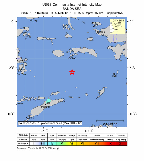
Felt (V) on Ambon; (IV) at Kupang, Saumlaki, Sorong, Tual, and Waingapu; (III) at Makassar, Indonesia. Felt at Denpasar. Felt (IV) at Dili, East Timor; (III) at Darwin and (II) at Palmerston, Australia. Felt (III PIVS) at Marawi and (II PIVS) at Davao, Philippines. Also felt at Jabiru, Howard Springs and Humpty Doo-MacMinns Lagoon, Australia.
From the USGS event page for usp000e8ys. U.S. Geological Survey text and figures are in the public domain.
Did you feel it?
74 people reported to the USGS what they felt; the strongest reported shaking was IV, light shaking.
Fault motion and ground failure
How the rock slipped, from the moment tensor, and the USGS estimate of landslides and liquefaction.
- Faulting
- Oblique normal
- Moment magnitude
- 7.7 Mww
- Nodal plane 1
- Strike 166°, dip 63°, rake 236°
- Nodal plane 2
- Strike 43°, dip 41°, rake -41°
Tectonic setting
Why earthquakes happen here, from the USGS tectonic summary.
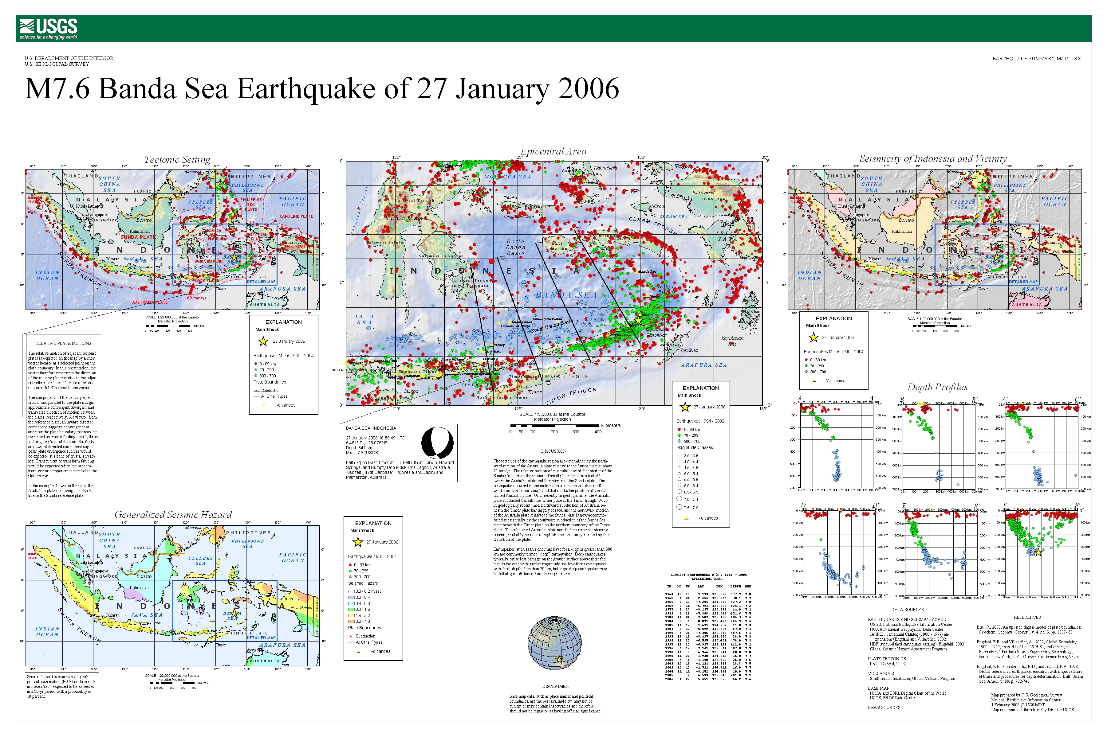
The January 27, 2006, M 7.6 Banda Sea earthquake occurred as the result of deep oblique normal faulting approximately 397 km beneath the Banda Sea, in the tectonically complex region of southeastern Indonesia. Here, the overall convergence between the Australia and Sunda plates is accommodated by the relative motions of numerous small microplates, including the Banda Sea and Timor microplates local to this event. Focal mechanism solutions for the earthquake indicate that rupture occurred on either a northeast or south-southeast-striking, moderately dipping normal fault. Slip on a fault of either orientation would accommodate the down-dip extension of the Australia slab that is implied by the normal-component of the faulting solution. At the location of the event, the Australia plate moves northward relative to the Sunda plate at a velocity of about 70 mm/yr. The earthquake occurred in the inclined seismic zone that dips northward from the Timor trough and that marks the position of the subducted Australia plate at depth.
Until recently in geologic time, the Australia plate subducted beneath the Timor microplate at the Timor trough. Within geologically recent time, northward subduction of Australia beneath the Timor plate has largely ceased, and the northward motion of the Australia plate relative to the Sunda plate is now accommodated substantially by the southward subduction of the Banda Sea microplate beneath the Timor microplate on the northern boundary of the Timor microplate. The subducted Australia plate nonetheless remains intensely seismic, probably because of high stresses that are generated by the distortion of the slab at depth.
The tectonically complex region surrounding the Banda Sea experiences large earthquakes fairly regularly. Eight other M 7 or larger earthquakes have occurred within 400 km of the January 27th event over the preceding 40 years. The largest was a M 7.3 earthquake in December 1992, nearly 200 km to the southeast, with no associated damage or casualties.
Earthquakes that have focal depths greater than 300 km are commonly termed “deep-focus” earthquakes. Deep-focus earthquakes cause less damage on the ground surface above their foci than similar-magnitude shallow-focus earthquakes, but large deep-focus earthquakes may be felt at great distance from their epicenters. The largest recorded deep-focus earthquake prior to this January 2006 earthquake was a M 8.2 event that occurred at a depth of 630 km within the subducted Nazca plate beneath South America near the northern Bolivian border in 1994. A larger event has since occurred, namely the M 8.3 earthquake that occurred at a depth of 600 km within the subducted Pacific plate beneath the Sea of Okhotsk offshore of northeastern Russia in 2013. The M 8.3 Sea of Okhotsk earthquake was felt all over Asia, as far away as Moscow, and across the Pacific Ocean along the western seaboard of the United States (though at distant locations, individuals reporting having felt the event were likely very favorably situated for the perception of small ground motions). The M 8.2 Bolivian deep-focus earthquake in 1994 had similarly been reported by individuals in North America at great distance from the epicenter.
Over the past century, 74 earthquakes with a magnitude of M 7+ have occurred at depths greater than 300 km globally; 7 of these were located in the same region as the January 27, 2006, event. The largest nearby event at these depths was a M 7.9 earthquake in June 1996, several hundred kilometers to the southwest and 210 km deeper than the January 27th event. The June 1996 event resulted in only minor damage at Kupang, Indonesia.
Hayes et al. (2016) Tectonic summaries of magnitude 7 and greater earthquakes from 2000 to 2015, USGS Open-File Report 2016-1192. (5.2 MB PDF)
From the USGS event page for usp000e8ys. U.S. Geological Survey text and figures are in the public domain.
USGS summary poster
How well it is located
Reviewed by a seismologist.
- Depth from
- OPERATOR_ASSIGNED
- Station coverage gap
- 22°
- Stations used
- 560
Nearest places
Distance and direction from each place to the epicenter, with its forecast.
Nearby
Within 100 km, magnitude 4.6 and up: 0 in the 60 days after this one and 0 in the 30 days before it.
None recorded.
Earthquakes todayIndonesia earthquakesLive radar here
Sources
From the USGS Earthquake Hazards Program and its partner networks, event usp000e8ys (also filed as us2006ika7, choy20060127165853, gcmtm200601271658a, gcmt20060127165853, duputel200601271658a, iscgem8079410). Read Fri, Oct 2, 2026, 3:43 PM UTC.