M7.6 earthquake Carlsberg Ridge
A magnitude 7.6 earthquake struck in the Carlsberg Ridge on Wed, Jul 16, 2003, 1:27 AM GMT+5 (20:27 UTC), 10 km (6 mi) below the surface.
Map
Where this earthquake was located, with the others nearby. Select one for its page.
The earthquake
- Magnitude
- 7.6 (Mwc, centroid moment), major
- Magnitude from
- USGS National Earthquake Information Center
- Local time
- UTC
- 2003-07-15 20:27:50 UTC
- Depth
- 10.0 km (6.2 mi), shallow
- Epicenter
- 2.598° S, 68.382° E
- Tsunami flag
- No
- Status
- Reviewed by a seismologist
Magnitude estimates
Different scales measure different things and differ by a few tenths. The USGS marks one as preferred, and it is the one this page uses.
| Mag. | Scale | Computed by | Notes |
|---|---|---|---|
| 7.6 | Mwc, centroid moment | USGS National Earthquake Information Center | Preferred · Reviewed |
| 7.54 | Mw, moment | ISC-GEM global catalog | Final · ±0.1 |
| 7.5 | Mwc, centroid moment | Global CMT project | Preliminary |
| 7.57 | Me, energy | Choy, USGS energy magnitude | Reviewed |
| 7.6 | Mww, W-phase moment | Duputel, W-phase inversion | Preliminary |
| 7.53 | Mw, moment | USGS finite-fault model | Finite-fault model · Reviewed |
Deaths and damage
From NOAA NCEI’s Significant Earthquake Database (record 5706), matched to this event by time and place.
NOAA’s record of this earthquake gives no deaths, injuries or damage.
What happened
The USGS’s account of the effects of this earthquake.
Felt strongly in Maldives.
From the USGS event page for usp000c2ka. U.S. Geological Survey text and figures are in the public domain.
Did you feel it?
No one has reported feeling this quake to the USGS.
Fault motion and ground failure
How the rock slipped, from the moment tensor, and the USGS estimate of landslides and liquefaction.
- Faulting
- Strike-slip
- Moment magnitude
- 7.6 Mww
- Nodal plane 1
- Strike 301°, dip 67°, rake 342°
- Nodal plane 2
- Strike 38°, dip 74°, rake -156°
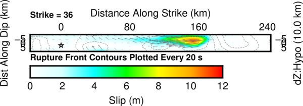
Rupture model
How far the rock on each part of the fault slid, from a model fitted to seismic waves recorded around the world.
Tectonic setting
Why earthquakes happen here, from the USGS tectonic summary.
The July 15, 2003, M 7.6 earthquake on the Carlsberg Ridge occurred as the result of shallow transform faulting within a mid-ocean ridge system, located in the Arabia Sea between India and Northern Africa. The ridge marks the boundary between the India and Nubia (Africa) plates. Focal mechanism solutions indicate that rupture occurred on either a left-lateral northwest-striking fault or a right-lateral northeast-striking fault; the latter is consistent with the orientation of the local plate boundary. Of the two possible fault orientations, finite-fault modeling of globally recorded seismic data is also more consistent with slip on the northeast-striking (right-lateral) fault. At the location of the earthquake, the India plate is moving to the northeast away from the Nubia plate at a rate of 33 mm/yr.
The Carlsberg Ridge is a slow-spreading ridge with rough topography and a depth that ranges from 1,700 to 4,400 m. Mid-ocean ridges are divergent plate boundaries, where two tectonic plates move apart from each other. New oceanic crust is formed as magma rises up between the two diverging plates. Active spreading ridges are offset by transform faults, where plates slide horizontally past each other neither destroying nor forming crust. This gives the plate boundary a zigzag pattern. Ocean ridges represent the longest linear uplifted features of the Earth’s surface and are marked by a belt of shallow earthquakes. Earthquakes can be caused by the release of tensional stress in the uplifted ridge or by the horizontal movement of plates along the transform faults.
While commonly plotted as points on maps, earthquakes of this size are more appropriately described as slip over a larger fault area. Strike-slip events of the size of the July 15, 2003, earthquake are typically about 140x20 km (length x width); modeling of this earthquake implies dimensions of about 100x20 km, well to the northeast of the hypocenter.
Few large earthquakes occur along mid-ocean ridges. Only three events greater than M 6 have occurred within 400 km of the July 15th event over the preceding 40 years; all were shallow M 6.0 earthquakes. Due to the remote location of these far from population centers that might be vulnerable to earthquake shaking, none have recorded damage or casualties.
Hayes et al. (2016) Tectonic summaries of magnitude 7 and greater earthquakes from 2000 to 2015, USGS Open-File Report 2016-1192. (5.2 MB PDF)
From the USGS event page for usp000c2ka. U.S. Geological Survey text and figures are in the public domain.
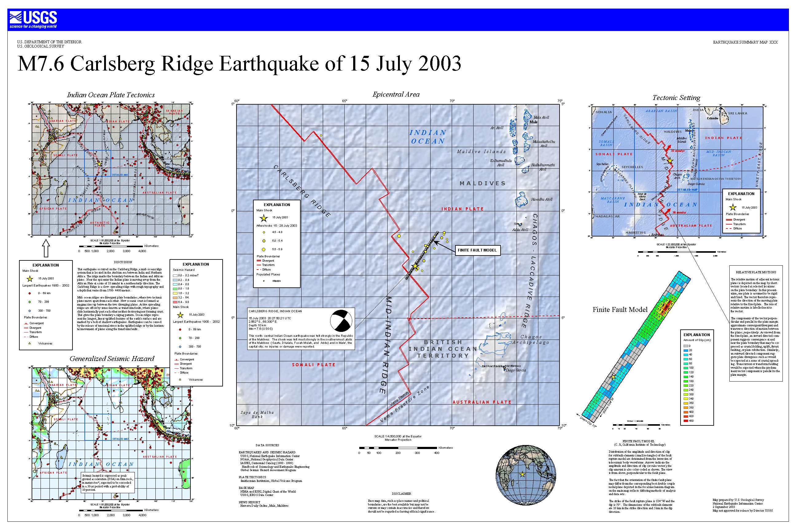
USGS summary poster
How well it is located
Reviewed by a seismologist.
- Depth from
- OPERATOR_ASSIGNED
- Station coverage gap
- 35°
- Stations used
- 522
Nearby
Within 100 km, magnitude 4.6 and up: 8 in the 60 days after this one and 0 in the 30 days before it.
After
- 5.4Carlsberg Ridge · 8479 days ago · 10 km deep · 40 km away
- 4.7Carlsberg Ridge · 8479 days ago · 10 km deep · 94 km away
- 4.9Carlsberg Ridge · 8479 days ago · 10 km deep · 26 km away
- 4.9Carlsberg Ridge · 8479 days ago · 10 km deep · 97 km away
- 4.9Carlsberg Ridge · 8479 days ago · 10 km deep · 23 km away
- 5.6Carlsberg Ridge · 8479 days ago · 10 km deep · 7 km away
- 4.6Carlsberg Ridge · 8475 days ago · 10 km deep · 65 km away
- 4.6Carlsberg Ridge · 8474 days ago · 10 km deep · 14 km away
Earthquakes todayLive radar here
Sources
From the USGS Earthquake Hazards Program and its partner networks, event usp000c2ka (also filed as duputel071503f, choy20030715202750, gcmtc071503f, gcmt20030715202750, iscgem6999304). Read Thu, Oct 1, 2026, 5:00 PM UTC.