M3.8 earthquake 22 km NE of Soledad, California
A magnitude 3.8 earthquake struck 22 km NE of Soledad, California on Fri, May 24, 2002, 10:44 AM PDT (17:44 UTC), 2 km (1 mi) below the surface.
Map
Where this earthquake was located, with the others nearby. Select one for its page.
The earthquake
- Magnitude
- 3.8 (ML, local (Richter)), minor
- Magnitude from
- Northern California Seismic System
- Local time
- UTC
- 2002-05-24 17:44:01 UTC
- Depth
- 1.9 km (1.2 mi), shallow
- Epicenter
- 36.549° N, 121.130° W
- Region
- California
- Strongest shaking
- II, weak shaking
- Tsunami flag
- No
- Status
- Reviewed by a seismologist
Magnitude estimates
Different scales measure different things and differ by a few tenths. The USGS marks one as preferred, and it is the one this page uses.
| Mag. | Scale | Computed by | Notes |
|---|---|---|---|
| 3.75 | ML, local (Richter) | Northern California Seismic System | Preferred · Final · 13 stations |
| 3.8 | ML, local (Richter) | USGS National Earthquake Information Center | Reviewed |
What happened
The USGS’s account of the effects of this earthquake.
Felt (IV) at Paicines.
From the USGS event page for nc21227108. U.S. Geological Survey text and figures are in the public domain.
Shaking
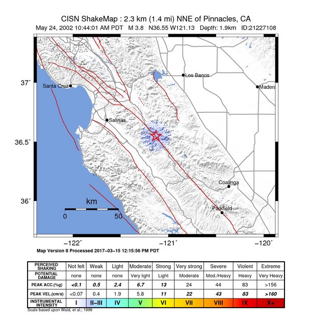
The USGS ShakeMap: shaking estimated from seismic stations and the quake’s size, on the Modified Mercalli intensity scale.
- Strongest estimated
- II, weak shaking
- Map
- Automatic
Did you feel it?
No one has reported feeling this quake to the USGS.
How well it is located
Reviewed by a seismologist.
- Location uncertainty
- About 0.1 km horizontally, 0.3 km in depth
- Depth from
- From location
- Station coverage gap
- 40°
- Stations used
- 73
Nearest places
Distance and direction from each place to the epicenter, with its forecast.
Nearby
Within 100 km, magnitude 1.5 and up: 194 in the 60 days after this one and 90 in the 30 days before it.
After
- 1.722 km NE of Soledad, California · 8899 days ago · 2 km deep · 0 km away
- 1.910 km S of Tres Pinos, California · 8899 days ago · 5 km deep · 25 km away
- 2.322 km NE of Soledad, California · 8898 days ago · 2 km deep · 0 km away
- 1.69 km NE of San Martin, California · 8897 days ago · 7 km deep · 76 km away
- 2.422 km NE of Soledad, California · 8897 days ago · 2 km deep · 0 km away
- 1.924 km NE of Soledad, California · 8896 days ago · 3 km deep · 2 km away
- 1.8Central California · 8896 days ago · 3 km deep · 17 km away
- 2.025 km ENE of Greenfield, California · 8895 days ago · 1 km deep · 17 km away
- 1.826 km ENE of Greenfield, California · 8895 days ago · 0 km deep · 17 km away
- 2.422 km NE of Soledad, California · 8895 days ago · 2 km deep · 0 km away
- 1.76 km SSE of San Juan Bautista, California · 8895 days ago · 8 km deep · 44 km away
- 1.525 km ENE of Greenfield, California · 8895 days ago · -1 km deep · 17 km away
- 2.19 km E of Gilroy, California · 8895 days ago · 5 km deep · 58 km away
- 1.57 km NE of Ridgemark, California · 8895 days ago · 5 km deep · 39 km away
- 2.45 km SSW of Gilroy, California · 8895 days ago · 6 km deep · 62 km away
- 2.422 km NNE of Soledad, California · 8895 days ago · 2 km deep · 9 km away
- 1.95 km SSW of Gilroy, California · 8895 days ago · 6 km deep · 62 km away
- 1.74 km SSE of Gilroy, California · 8895 days ago · 0 km deep · 60 km away
- 1.714 km SW of Tres Pinos, California · 8894 days ago · 8 km deep · 30 km away
- 2.223 km NE of San Lucas, California · 8894 days ago · 5 km deep · 36 km away
- 1.613 km SW of Tres Pinos, California · 8894 days ago · 10 km deep · 29 km away
- 1.810 km NNW of Avenal, California · 8894 days ago · 7 km deep · 100 km away
- 2.48 km NE of Ridgemark, California · 8894 days ago · 5 km deep · 39 km away
- 2.95 km E of Interlaken, California · 8894 days ago · 6 km deep · 66 km away
- 2.222 km NE of Soledad, California · 8894 days ago · 1 km deep · 0 km away
- 1.910 km NNW of Avenal, California · 8894 days ago · 8 km deep · 100 km away
- 2.47 km NE of Ridgemark, California · 8894 days ago · 5 km deep · 39 km away
- 1.911 km NNW of Avenal, California · 8893 days ago · 8 km deep · 100 km away
- 2.810 km NNW of Avenal, California · 8892 days ago · 8 km deep · 100 km away
- 1.911 km NNW of Avenal, California · 8891 days ago · 6 km deep · 99 km away
- 2.310 km NNW of Avenal, California · 8891 days ago · 7 km deep · 100 km away
- 1.629 km ESE of Tres Pinos, California · 8890 days ago · 0 km deep · 21 km away
- 1.515 km NW of Parkfield, California · 8890 days ago · 4 km deep · 80 km away
- 2.020 km SSE of Tres Pinos, California · 8890 days ago · 5 km deep · 12 km away
- 1.727 km ESE of Tres Pinos, California · 8890 days ago · 4 km deep · 15 km away
- 1.82 km ENE of San Ardo, California · 8889 days ago · 10 km deep · 62 km away
- 2.017 km SSE of Tres Pinos, California · 8889 days ago · 4 km deep · 15 km away
- 1.729 km SSW of South Dos Palos, California · 8889 days ago · 0 km deep · 39 km away
- 1.723 km NE of Soledad, California · 8889 days ago · 2 km deep · 2 km away
- 2.313 km ENE of Bradley, California · 8888 days ago · 11 km deep · 80 km away
- 2.313 km ENE of Bradley, California · 8888 days ago · 11 km deep · 80 km away
- 1.85 km SW of Gilroy, California · 8888 days ago · 6 km deep · 64 km away
- 1.75 km WSW of Ridgemark, California · 8887 days ago · 5 km deep · 38 km away
- 2.14 km NE of Coalinga, California · 8886 days ago · 14 km deep · 84 km away
- 1.624 km NE of Greenfield, California · 8886 days ago · 7 km deep · 10 km away
- 1.921 km NE of Soledad, California · 8886 days ago · 2 km deep · 0 km away
- 3.222 km NE of Soledad, California · 8886 days ago · 2 km deep · 0 km away
- 2.322 km NE of Soledad, California · 8885 days ago · 2 km deep · 0 km away
- 2.24 km NE of Coalinga, California · 8885 days ago · 13 km deep · 84 km away
- 1.813 km S of Tres Pinos, California · 8885 days ago · 4 km deep · 20 km away
- 2.211 km NNW of Coalinga, California · 8885 days ago · 12 km deep · 73 km away
- 3.014 km N of Coalinga, California · 8885 days ago · 9 km deep · 78 km away
- 1.86 km SSW of Gilroy, California · 8884 days ago · 5 km deep · 61 km away
- 2.012 km S of Tres Pinos, California · 8884 days ago · 5 km deep · 21 km away
- 2.622 km NW of Parkfield, California · 8884 days ago · 5 km deep · 73 km away
- 2.823 km ENE of San Lucas, California · 8884 days ago · 8 km deep · 46 km away
- 1.817 km W of Diablo Grande, California · 8884 days ago · 8 km deep · 97 km away
- 2.46 km SSE of Gilroy, California · 8884 days ago · 4 km deep · 58 km away
- 2.32 km NNW of Aromas, California · 8883 days ago · 11 km deep · 62 km away
- 1.621 km NE of Soledad, California · 8883 days ago · 2 km deep · 1 km away
The first 60 of 194.
Before
- 2.718 km SSE of Tres Pinos, California · 8900 days ago · 7 km deep · 13 km away
- 2.123 km NE of King City, California · 8901 days ago · 6 km deep · 25 km away
- 1.621 km NE of Soledad, California · 8901 days ago · 6 km deep · 4 km away
- 2.113 km WSW of Gonzales, California · 8901 days ago · 29 km deep · 42 km away
- 1.813 km SW of Tres Pinos, California · 8901 days ago · 10 km deep · 29 km away
- 1.5Central California · 8902 days ago · 0 km deep · 15 km away
- 1.712 km S of Tres Pinos, California · 8902 days ago · 5 km deep · 21 km away
- 3.14 km E of Interlaken, California · 8902 days ago · 6 km deep · 67 km away
- 1.624 km NE of Greenfield, California · 8902 days ago · 5 km deep · 11 km away
- 2.412 km S of Tres Pinos, California · 8903 days ago · 4 km deep · 21 km away
- 1.64 km NNW of Aromas, California · 8903 days ago · 10 km deep · 64 km away
- 1.817 km SSE of Tres Pinos, California · 8903 days ago · 4 km deep · 15 km away
- 2.611 km S of Tres Pinos, California · 8903 days ago · 4 km deep · 22 km away
- 3.312 km S of Tres Pinos, California · 8903 days ago · 5 km deep · 22 km away
- 1.611 km WSW of Huron, California · 8904 days ago · 8 km deep · 93 km away
- 2.134 km W of Three Rocks, California · 8904 days ago · 13 km deep · 33 km away
- 2.113 km ESE of Coalinga, California · 8904 days ago · 10 km deep · 95 km away
- 2.013 km ESE of Coalinga, California · 8904 days ago · 9 km deep · 96 km away
- 1.810 km ESE of Coalinga, California · 8905 days ago · 13 km deep · 92 km away
- 1.621 km NE of Soledad, California · 8905 days ago · 7 km deep · 6 km away
Earthquakes todayCalifornia earthquakesLive radar here
Sources
From the USGS Earthquake Hazards Program and its partner networks, event nc21227108 (also filed as usp000b4wq). Read Mon, Oct 5, 2026, 7:01 AM UTC.