M3.8 earthquake 12km NNE of Simi Valley, CA
A magnitude 3.8 earthquake struck 12km NNE of Simi Valley, CA on Mon, Jan 28, 2002, 10:08 PM PST (06:08 UTC), 14 km (9 mi) below the surface.
A larger quake followed: M4.6 33km NW of Santa Barbara Is., CA. This one was a foreshock.
Map
Where this earthquake was located, with the others nearby. Select one for its page.
The earthquake
- Magnitude
- 3.8 (ML, local (Richter)), minor
- Magnitude from
- Southern California Seismic Network
- Local time
- UTC
- 2002-01-29 06:08:01 UTC
- Depth
- 14.0 km (8.7 mi), shallow
- Epicenter
- 34.365° N, 118.664° W
- Region
- California
- Felt reports
- 241
- Tsunami flag
- No
- Status
- Reviewed by a seismologist
Magnitude estimates
Different scales measure different things and differ by a few tenths. The USGS marks one as preferred, and it is the one this page uses.
| Mag. | Scale | Computed by | Notes |
|---|---|---|---|
| 3.8 | ML, local (Richter) | Southern California Seismic Network | Preferred · Final · ±0.275 · 88 stations |
| 3.8 | ML, local (Richter) | USGS National Earthquake Information Center | Reviewed |
What happened
The USGS’s account of the effects of this earthquake.
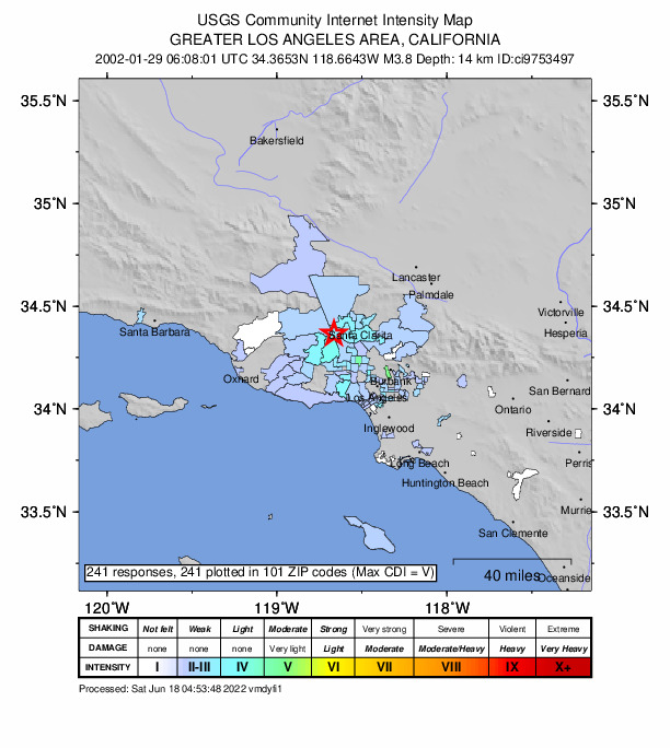
Felt (IV) at Simi Valley and Valencia; (III) at Canyon Country, Los Angeles, Santa Clarita and Woodland Hills; (II) at Castaic, Pasadena, Santa Monica and Thousand Oaks. Felt in Los Angeles and Ventura Counties.
From the USGS event page for ci9753497. U.S. Geological Survey text and figures are in the public domain.
Did you feel it?
241 people reported to the USGS what they felt; the strongest reported shaking was V, moderate shaking.
How well it is located
Reviewed by a seismologist.
- Location uncertainty
- About 0.3 km horizontally, 0.7 km in depth
- Magnitude uncertainty
- ±0.28
- Depth from
- From location
- Station coverage gap
- 22°
- Stations used
- 74
Nearest places
Distance and direction from each place to the epicenter, with its forecast.
Nearby
Within 100 km, magnitude 1.5 and up: 192 in the 60 days after this one and 52 in the 30 days before it.
After
- 2.812km NE of Simi Valley, CA · 9015 days ago · 14 km deep · 1 km away
- 2.812km NE of Simi Valley, CA · 9015 days ago · 14 km deep · 1 km away
- 1.711km NNE of Simi Valley, CA · 9015 days ago · 16 km deep · 1 km away
- 2.312km NNE of Simi Valley, CA · 9015 days ago · 14 km deep · 0 km away
- 1.811km NNE of Simi Valley, CA · 9015 days ago · 15 km deep · 1 km away
- 2.112km NE of Simi Valley, CA · 9015 days ago · 14 km deep · 1 km away
- 2.913km SW of Valencia, CA · 9015 days ago · 13 km deep · 1 km away
- 2.412km NE of Simi Valley, CA · 9015 days ago · 15 km deep · 0 km away
- 1.712km NNE of Simi Valley, CA · 9015 days ago · 14 km deep · 1 km away
- 1.912km NNE of Simi Valley, CA · 9015 days ago · 16 km deep · 1 km away
- 1.512km NE of Simi Valley, California · 9015 days ago · 16 km deep · 1 km away
- 2.011km NNE of Simi Valley, CA · 9015 days ago · 14 km deep · 1 km away
- 1.712km NNE of Simi Valley, CA · 9015 days ago · 14 km deep · 1 km away
- 1.812km NNE of Simi Valley, CA · 9015 days ago · 14 km deep · 2 km away
- 1.812km NE of Simi Valley, CA · 9015 days ago · 14 km deep · 1 km away
- 1.912km NNE of Simi Valley, CA · 9015 days ago · 14 km deep · 0 km away
- 1.512km NE of Simi Valley, California · 9014 days ago · 13 km deep · 0 km away
- 2.411km NE of Simi Valley, CA · 9014 days ago · 15 km deep · 1 km away
- 1.811km NNE of Simi Valley, CA · 9014 days ago · 17 km deep · 2 km away
- 2.111km NNE of Simi Valley, CA · 9014 days ago · 13 km deep · 2 km away
- 1.911km NNE of Simi Valley, CA · 9014 days ago · 14 km deep · 1 km away
- 2.812km NE of Simi Valley, California · 9014 days ago · 15 km deep · 0 km away
- 2.928km SSE of Santa Cruz Is. (E end), CA · 9014 days ago · 7 km deep · 98 km away
- 2.412km NNW of Chatsworth, CA · 9014 days ago · 14 km deep · 1 km away
- 1.820km ENE of Arvin, CA · 9014 days ago · 7 km deep · 99 km away
- 2.712km NE of Simi Valley, CA · 9014 days ago · 11 km deep · 1 km away
- 1.710km NNE of Simi Valley, CA · 9014 days ago · 14 km deep · 3 km away
- 1.512km NNW of Chatsworth, California · 9014 days ago · 15 km deep · 2 km away
- 1.612km NNE of Simi Valley, California · 9014 days ago · 16 km deep · 2 km away
- 1.511km NNE of Simi Valley, California · 9014 days ago · 12 km deep · 2 km away
- 3.612km NNE of Simi Valley, CA · 9014 days ago · 12 km deep · 0 km away · felt by 145
- 2.412km NE of Simi Valley, CA · 9014 days ago · 12 km deep · 1 km away
- 1.613km SW of Valencia, CA · 9014 days ago · 14 km deep · 0 km away
- 1.810km NNE of Simi Valley, CA · 9014 days ago · 15 km deep · 4 km away
- 3.113km SW of Valencia, CA · 9014 days ago · 12 km deep · 0 km away · felt by 243
- 1.812km NE of Simi Valley, CA · 9014 days ago · 13 km deep · 1 km away
- 2.212km NNE of Simi Valley, CA · 9014 days ago · 14 km deep · 1 km away
- 1.612km NNE of Simi Valley, CA · 9014 days ago · 12 km deep · 1 km away
- 1.912km NNE of Simi Valley, CA · 9014 days ago · 15 km deep · 1 km away
- 2.511km NNE of Simi Valley, CA · 9014 days ago · 14 km deep · 1 km away
- 1.77km SE of Piru, California · 9014 days ago · 7 km deep · 7 km away
- 1.610km SE of Piru, California · 9014 days ago · 17 km deep · 4 km away
- 2.212km NE of Simi Valley, CA · 9014 days ago · 12 km deep · 1 km away
- 1.611km NNE of Simi Valley, CA · 9014 days ago · 11 km deep · 1 km away
- 2.213km SW of Valencia, CA · 9014 days ago · 13 km deep · 1 km away
- 1.811km NNE of Simi Valley, CA · 9014 days ago · 14 km deep · 2 km away
- 1.512km NNE of Simi Valley, CA · 9014 days ago · 14 km deep · 1 km away
- 2.712km NE of Simi Valley, CA · 9014 days ago · 12 km deep · 1 km away
- 1.812km NNE of Simi Valley, CA · 9014 days ago · 13 km deep · 1 km away
- 1.612km NNE of Simi Valley, CA · 9014 days ago · 11 km deep · 0 km away
- 2.013km NE of Simi Valley, CA · 9014 days ago · 12 km deep · 1 km away
- 2.212km ESE of Piru, CA · 9014 days ago · 12 km deep · 1 km away
- 2.312km NNE of Simi Valley, CA · 9013 days ago · 13 km deep · 1 km away
- 1.912km NNE of Simi Valley, CA · 9013 days ago · 14 km deep · 1 km away
- 3.513km SW of Valencia, CA · 9013 days ago · 12 km deep · 0 km away · felt by 433
- 1.513km NNW of Chatsworth, CA · 9013 days ago · 12 km deep · 1 km away
- 1.912km ESE of Piru, CA · 9013 days ago · 14 km deep · 2 km away
- 3.012km NE of Simi Valley, CA · 9013 days ago · 12 km deep · 0 km away · felt by 234
- 2.211km NNE of Simi Valley, CA · 9013 days ago · 13 km deep · 2 km away
- 1.811km NNE of Simi Valley, CA · 9013 days ago · 13 km deep · 2 km away
The first 60 of 192.
Before
- 1.711km NNE of Simi Valley, CA · 9015 days ago · 18 km deep · 2 km away
- 3.913km ESE of Piru, CA · 9015 days ago · 14 km deep · 1 km away · felt by 470
- 4.213km NE of Simi Valley, CA · 9015 days ago · 14 km deep · 1 km away · felt by 2,106
- 3.112km NNW of Chatsworth, CA · 9015 days ago · 13 km deep · 2 km away
- 1.513km NW of Grapevine, California · 9015 days ago · 22 km deep · 81 km away
- 1.918km S of Malibu Beach, CA · 9016 days ago · 12 km deep · 55 km away
- 1.82km W of San Fernando, CA · 9017 days ago · 11 km deep · 21 km away
- 1.84km ESE of Marina del Rey, CA · 9017 days ago · 13 km deep · 50 km away
- 1.82km NW of Granada Hills, CA · 9018 days ago · 10 km deep · 16 km away
- 1.55km S of Frazier Park, California · 9018 days ago · 13 km deep · 53 km away
- 1.95km SSW of Encino, CA · 9018 days ago · 5 km deep · 30 km away
- 1.64km NE of Yorba Linda, CA · 9018 days ago · 11 km deep · 95 km away
- 1.75km NNW of Rancho Cucamonga, CA · 9019 days ago · 12 km deep · 100 km away
- 1.74km SSE of Chino Hills, CA · 9019 days ago · 14 km deep · 96 km away
- 1.910km NNW of Piru, California · 9020 days ago · 12 km deep · 22 km away
- 1.81km W of Beverly Hills, CA · 9021 days ago · 10 km deep · 40 km away
- 2.117km NNW of Fillmore, CA · 9021 days ago · 20 km deep · 35 km away
- 3.317km NNW of Fillmore, CA · 9022 days ago · 22 km deep · 35 km away
- 2.04km S of San Pedro, California · 9022 days ago · 6 km deep · 82 km away
- 1.64km W of East Los Angeles, CA · 9023 days ago · 15 km deep · 56 km away
Earthquakes todayCalifornia earthquakesLive radar here
Sources
From the USGS Earthquake Hazards Program and its partner networks, event ci9753497 (also filed as ci09753497, usp000axcj). Read Sun, Oct 4, 2026, 8:24 PM UTC.