M7.2 earthquake 50 km WNW of Port-Vila, Vanuatu
A magnitude 7.2 earthquake struck 50 km WNW of Port-Vila, Vanuatu on Thu, Jan 3, 2002, 4:22 AM GMT+11 (17:22 UTC), 21 km (13 mi) below the surface.
Map
Where this earthquake was located, with the others nearby. Select one for its page.
The earthquake
- Magnitude
- 7.2 (Mwc, centroid moment), major
- Magnitude from
- USGS National Earthquake Information Center
- Local time
- UTC
- 2002-01-02 17:22:48 UTC
- Depth
- 21.0 km (13.0 mi), shallow
- Epicenter
- 17.600° S, 167.856° E
- Region
- Vanuatu
- Strongest shaking
- VI, strong shaking
- Tsunami flag
- No
- Status
- Reviewed by a seismologist
Magnitude estimates
Different scales measure different things and differ by a few tenths. The USGS marks one as preferred, and it is the one this page uses.
| Mag. | Scale | Computed by | Notes |
|---|---|---|---|
| 7.2 | Mwc, centroid moment | USGS National Earthquake Information Center | Preferred · Reviewed |
| 7.2 | Mw, moment | ISC-GEM global catalog | Final · ±0.1 |
| 7.2 | Mwc, centroid moment | Global CMT project | Preliminary |
| 7.2 | Me, energy | Choy, USGS energy magnitude | Reviewed |
| 7.2 | Mww, W-phase moment | Duputel, W-phase inversion | Preliminary |
Deaths and damage
From NOAA NCEI’s Significant Earthquake Database (record 5614), matched to this event by time and place.
- Injuries
- Some (about 51 to 100)
- Damage
- Limited (under about $1 million)
- Houses damaged
- Some (about 51 to 100)
Where the literature gives no number, NCEI records a description on a scale of 1 to 4, printed here in its words. Damage is in millions of US dollars of the year of the event, not adjusted for inflation.
From Wikipedia
The 2002 Port Vila earthquake occurred in the early dawn of 3 January 2002, 4:22 a.m. local time (UTC+11) northwest of Port Vila, the capital of Vanuatu. It had a magnitude of 7.2 Mw and a maximum intensity of X (Extreme) west of the island on the Modified Mercalli intensity scale. There are no exact estimates on the number of injured individuals, but the majority of accounts say there were "several" amounts of injured civilians. the event also caused a minor tsunami of about 0.4–0.8 m just 11 minutes after the quake.
Text from Wikipedia, “2002 Port Vila earthquake”, licensed CC BY-SA 4.0. Quoted as written; the full article has the rest.
The article is about the earthquake NOAA’s record describes, matched to this one by date, place and magnitude.
What happened
The USGS’s account of the effects of this earthquake.
Several people injured, two bridges destroyed and buildings and roads damaged on Efate. Rockslides blocked access to the wharf at Port-Vila. A tsunami with wave heights of 40 cm (peak-to-trough) recorded at Port-Vila.
From the USGS event page for usp000avpw. U.S. Geological Survey text and figures are in the public domain.
Shaking
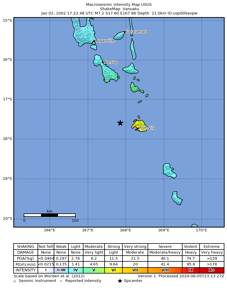
The USGS ShakeMap: shaking estimated from seismic stations and the quake’s size, on the Modified Mercalli intensity scale.
- Strongest estimated
- VI, strong shaking
- Peak ground acceleration
- 21.0% of gravity
- Peak ground velocity
- 3.1 cm/s
- Map
- Automatic
Did you feel it?
No one has reported feeling this quake to the USGS.
Fault motion and ground failure
How the rock slipped, from the moment tensor, and the USGS estimate of landslides and liquefaction.
- Faulting
- Reverse (thrust)
- Moment magnitude
- 7.2 Mww
- Nodal plane 1
- Strike 187°, dip 78°, rake 112°
- Nodal plane 2
- Strike 302°, dip 24°, rake 27°
Tectonic setting
Why earthquakes happen here, from the USGS tectonic summary.
The January 2, 2002, M 7.2 Vanuatu earthquake occurred as the result of shallow oblique reverse faulting on or near the convergent boundary between the Australia plate and the New Hebrides microplate (a segment of the much larger Pacific plate). Focal mechanism solutions indicate that rupture occurred on either a steeply dipping reverse fault or a shallowly dipping thrust fault striking northwest-southeast. At the location of the earthquake, the Australia plate moves to the east-northeast relative to the Pacific plate at a velocity of about 84 mm/yr, subducting at the New Hebrides Trench to the west of the January 2nd event. The earthquake’s location and depth are consistent with the earthquake having occurred close to the interplate thrust that defines the Australia-Pacific plate boundary at depth, though the obliquity of the focal mechanism solution to the subduction direction indicates that the event likely occurred on an intraplate fault within the Australia slab. Slip on a fault aligned with either nodal plane of the focal mechanism solution is consistent with this intraplate setting. The subducting Australia plate is seismically active to depths of about 300 km beneath the islands.
The Vanuatu region experiences a very high level of earthquake activity, with half a dozen events of M 7 or larger within 200 km of the January 2nd earthquake during the preceding 40 years. Recent large earthquakes near the January 2nd event include a M 7.5 earthquake in November 1999 and a M 7.2 earthquake in July 1994.
Hayes et al. (2016) Tectonic summaries of magnitude 7 and greater earthquakes from 2000 to 2015, USGS Open-File Report 2016-1192. (5.2 MB PDF)
From the USGS event page for usp000avpw. U.S. Geological Survey text and figures are in the public domain.
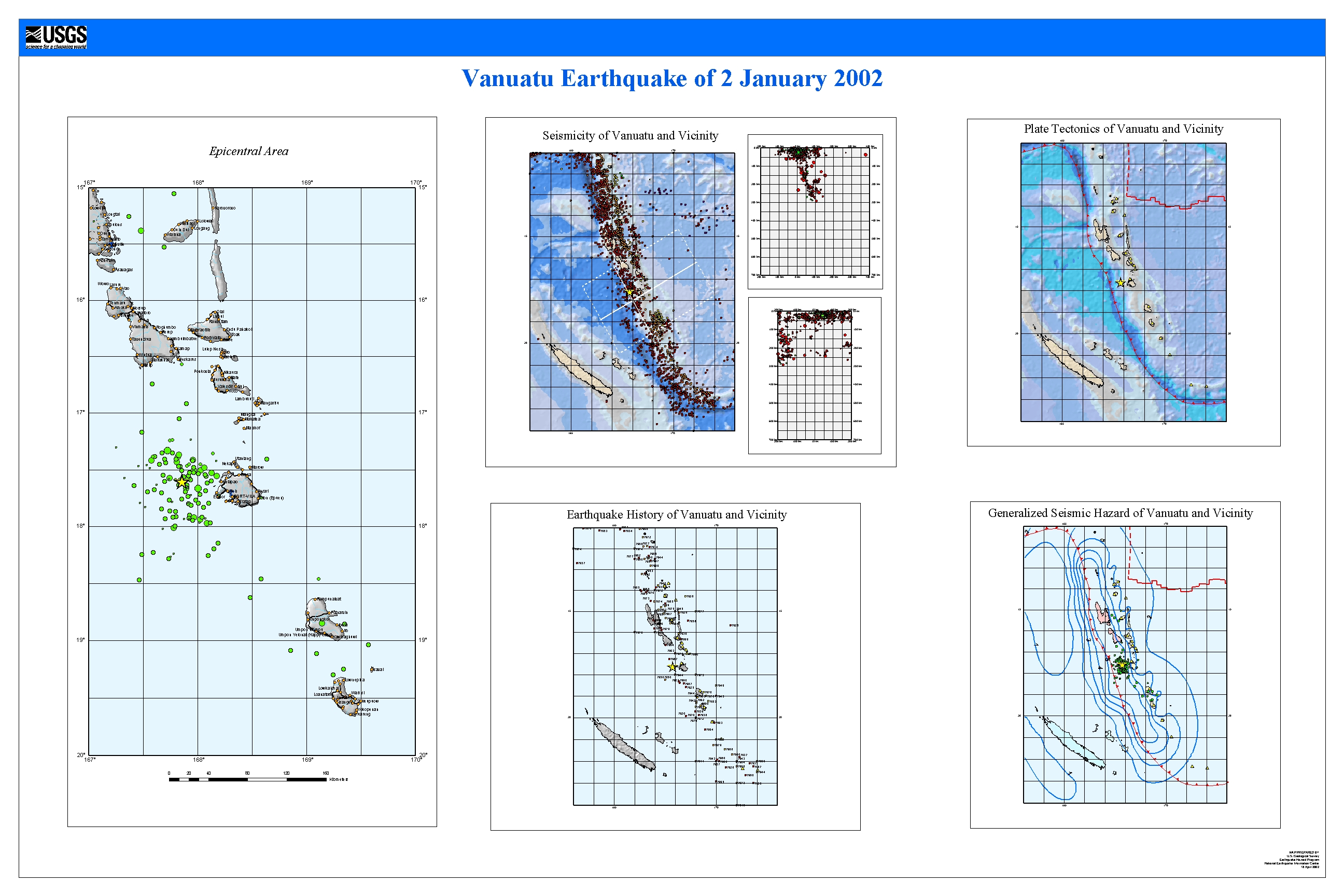
USGS summary poster
How well it is located
Reviewed by a seismologist.
- Depth from
- OPERATOR_ASSIGNED
- Stations used
- 427
Nearest places
Distance and direction from each place to the epicenter, with its forecast.
Nearby
Within 100 km, magnitude 4.2 and up: 74 in the 60 days after this one and 4 in the 30 days before it.
After
- 5.762 km WNW of Port-Vila, Vanuatu · 9039 days ago · 10 km deep · 12 km away
- 5.241 km WSW of Port-Vila, Vanuatu · 9039 days ago · 10 km deep · 38 km away
- 5.444 km W of Port-Vila, Vanuatu · 9039 days ago · 10 km deep · 9 km away
- 4.734 km W of Port-Vila, Vanuatu · 9039 days ago · 10 km deep · 23 km away
- 4.929 km WSW of Port-Vila, Vanuatu · 9039 days ago · 10 km deep · 33 km away
- 4.548 km W of Port-Vila, Vanuatu · 9039 days ago · 10 km deep · 17 km away
- 4.745 km W of Port-Vila, Vanuatu · 9039 days ago · 10 km deep · 11 km away
- 5.135 km SW of Port-Vila, Vanuatu · 9039 days ago · 10 km deep · 48 km away
- 4.923 km WSW of Port-Vila, Vanuatu · 9039 days ago · 10 km deep · 34 km away
- 4.312 km W of Port-Vila, Vanuatu · 9039 days ago · 10 km deep · 39 km away
- 6.633 km WNW of Port-Vila, Vanuatu · 9039 days ago · 10 km deep · 17 km away
- 4.942 km W of Port-Vila, Vanuatu · 9039 days ago · 10 km deep · 23 km away
- 4.366 km WNW of Port-Vila, Vanuatu · 9039 days ago · 10 km deep · 16 km away
- 5.238 km SW of Port-Vila, Vanuatu · 9038 days ago · 10 km deep · 42 km away
- 4.342 km W of Port-Vila, Vanuatu · 9038 days ago · 10 km deep · 16 km away
- 4.356 km WSW of Port-Vila, Vanuatu · 9038 days ago · 10 km deep · 30 km away
- 4.460 km WSW of Port-Vila, Vanuatu · 9038 days ago · 10 km deep · 36 km away
- 4.924 km NW of Port-Vila, Vanuatu · 9038 days ago · 10 km deep · 29 km away
- 4.444 km WSW of Port-Vila, Vanuatu · 9038 days ago · 10 km deep · 40 km away
- 4.860 km W of Port-Vila, Vanuatu · 9038 days ago · 10 km deep · 22 km away
- 5.564 km WSW of Port-Vila, Vanuatu · 9038 days ago · 10 km deep · 47 km away
- 4.867 km WSW of Port-Vila, Vanuatu · 9038 days ago · 10 km deep · 40 km away
- 4.571 km NW of Port-Vila, Vanuatu · 9037 days ago · 10 km deep · 29 km away
- 4.734 km SW of Port-Vila, Vanuatu · 9037 days ago · 10 km deep · 40 km away
- 4.832 km W of Port-Vila, Vanuatu · 9037 days ago · 10 km deep · 27 km away
- 5.261 km WSW of Port-Vila, Vanuatu · 9037 days ago · 10 km deep · 44 km away
- 4.557 km WSW of Port-Vila, Vanuatu · 9037 days ago · 10 km deep · 35 km away
- 4.3103 km WSW of Port-Vila, Vanuatu · 9036 days ago · 10 km deep · 81 km away
- 4.247 km SSW of Port-Vila, Vanuatu · 9036 days ago · 10 km deep · 70 km away
- 4.550 km WNW of Port-Vila, Vanuatu · 9036 days ago · 10 km deep · 5 km away
- 5.079 km WNW of Port-Vila, Vanuatu · 9036 days ago · 10 km deep · 34 km away
- 5.444 km NW of Port-Vila, Vanuatu · 9035 days ago · 10 km deep · 16 km away
- 4.274 km WNW of Port-Vila, Vanuatu · 9035 days ago · 10 km deep · 27 km away
- 4.724 km NW of Port-Vila, Vanuatu · 9035 days ago · 10 km deep · 34 km away
- 5.630 km NW of Port-Vila, Vanuatu · 9035 days ago · 10 km deep · 30 km away
- 4.831 km NW of Port-Vila, Vanuatu · 9035 days ago · 10 km deep · 24 km away
- 5.438 km NW of Port-Vila, Vanuatu · 9035 days ago · 10 km deep · 26 km away
- 4.291 km NW of Port-Vila, Vanuatu · 9035 days ago · 10 km deep · 61 km away
- 4.350 km NE of Port-Vila, Vanuatu · 9035 days ago · 10 km deep · 86 km away
- 5.227 km WNW of Port-Vila, Vanuatu · 9033 days ago · 10 km deep · 25 km away
- 5.746 km WNW of Port-Vila, Vanuatu · 9032 days ago · 10 km deep · 7 km away
- 4.469 km WNW of Port-Vila, Vanuatu · 9032 days ago · 10 km deep · 19 km away
- 4.284 km WNW of Port-Vila, Vanuatu · 9032 days ago · 10 km deep · 36 km away
- 4.425 km WNW of Port-Vila, Vanuatu · 9031 days ago · 10 km deep · 25 km away
- 4.544 km WNW of Port-Vila, Vanuatu · 9031 days ago · 10 km deep · 7 km away
- 4.946 km WSW of Port-Vila, Vanuatu · 9030 days ago · 10 km deep · 37 km away
- 5.265 km NW of Port-Vila, Vanuatu · 9029 days ago · 10 km deep · 22 km away
- 4.546 km WNW of Port-Vila, Vanuatu · 9029 days ago · 10 km deep · 9 km away
- 5.863 km WNW of Port-Vila, Vanuatu · 9028 days ago · 10 km deep · 19 km away
- 5.439 km NW of Port-Vila, Vanuatu · 9028 days ago · 10 km deep · 21 km away
- 4.539 km NW of Port-Vila, Vanuatu · 9028 days ago · 10 km deep · 18 km away
- 4.452 km WNW of Port-Vila, Vanuatu · 9028 days ago · 10 km deep · 5 km away
- 4.261 km SSW of Port-Vila, Vanuatu · 9028 days ago · 33 km deep · 77 km away
- 4.395 km W of Port-Vila, Vanuatu · 9027 days ago · 10 km deep · 46 km away
- 6.077 km NW of Port-Vila, Vanuatu · 9027 days ago · 10 km deep · 33 km away
- 5.465 km NW of Port-Vila, Vanuatu · 9027 days ago · 10 km deep · 24 km away
- 4.259 km WNW of Port-Vila, Vanuatu · 9027 days ago · 10 km deep · 15 km away
- 4.557 km WNW of Port-Vila, Vanuatu · 9027 days ago · 10 km deep · 15 km away
- 4.546 km NW of Port-Vila, Vanuatu · 9027 days ago · 10 km deep · 18 km away
- 4.277 km WNW of Port-Vila, Vanuatu · 9027 days ago · 10 km deep · 27 km away
The first 60 of 74.
Before
Earthquakes todayVanuatu earthquakesLive radar here
Sources
From the USGS Earthquake Hazards Program and its partner networks, event usp000avpw (also filed as choy20020102172248, gcmtc010202f, gcmt20020102172248, duputel010202f, atlas20020102172250, iscgem2431530). Read Fri, Oct 2, 2026, 10:59 PM UTC.