M4.8 earthquake 13km NW of Ludlow, CA
A magnitude 4.8 earthquake struck 13km NW of Ludlow, CA on Tue, Oct 29, 2002, 6:16 AM PST (14:16 UTC), 4 km (2 mi) below the surface.
Map
Where this earthquake was located, with the others nearby. Select one for its page.
The earthquake
- Magnitude
- 4.8 (ML, local (Richter)), light
- Magnitude from
- Southern California Seismic Network
- Local time
- UTC
- 2002-10-29 14:16:54 UTC
- Depth
- 3.7 km (2.3 mi), shallow
- Epicenter
- 34.803° N, 116.267° W
- Region
- California
- Felt reports
- 104
- Strongest shaking
- VI, strong shaking
- PAGER alert
- Green
- Tsunami flag
- No
- Status
- Reviewed by a seismologist
Magnitude estimates
Different scales measure different things and differ by a few tenths. The USGS marks one as preferred, and it is the one this page uses.
| Mag. | Scale | Computed by | Notes |
|---|---|---|---|
| 4.77 | ML, local (Richter) | Southern California Seismic Network | Preferred · Final · ±0.543 · 130 stations |
| 4.6 | Mwr, regional moment | USGS National Earthquake Information Center | Reviewed |
What happened
The USGS’s account of the effects of this earthquake.
Felt (IV) at Barstow and Newberry Springs; (III) at Apple Valley and Fort Irwin; (II) at Twentynine Palms and Victorville.
From the USGS event page for ci9854597. U.S. Geological Survey text and figures are in the public domain.
Shaking
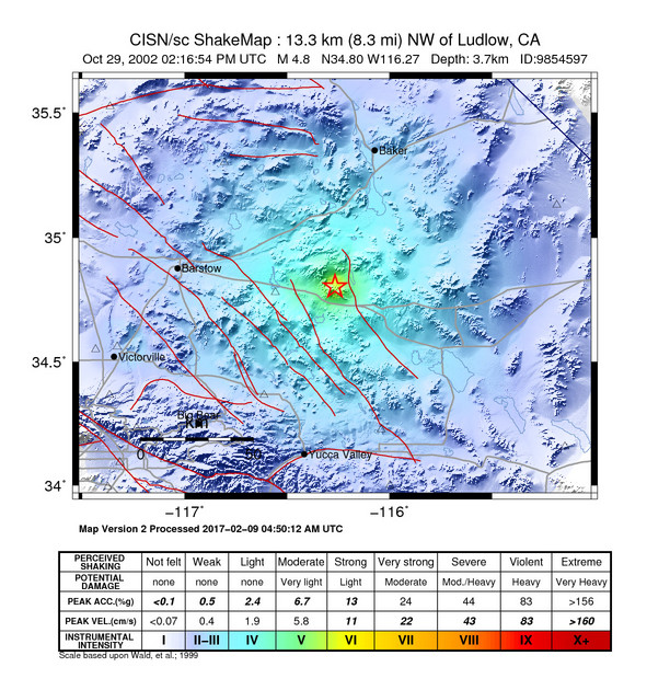
The USGS ShakeMap: shaking estimated from seismic stations and the quake’s size, on the Modified Mercalli intensity scale.
- Strongest estimated
- VI, strong shaking
- Map
- Automatic
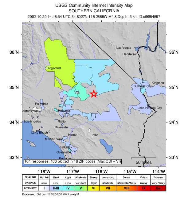
Did you feel it?
104 people reported to the USGS what they felt; the strongest reported shaking was VI, strong shaking.
Estimated impact
The USGS PAGER system estimates deaths and economic losses from the shaking and the population and buildings exposed to it.
- Alert level
- Green: little or no damage or loss of life expected
Fault motion and ground failure
How the rock slipped, from the moment tensor, and the USGS estimate of landslides and liquefaction.
- Faulting
- Strike-slip
- Nodal plane 1
- Strike 356°, dip 79°, rake 167°
- Nodal plane 2
- Strike 89°, dip 77°, rake 11°
How well it is located
Reviewed by a seismologist.
- Location uncertainty
- About 0.3 km horizontally, 0.5 km in depth
- Magnitude uncertainty
- ±0.54
- Depth from
- From location
- Station coverage gap
- 51°
- Stations used
- 31
Nearest places
Distance and direction from each place to the epicenter, with its forecast.
Nearby
Within 100 km, magnitude 1.8 and up: 94 in the 60 days after this one and 43 in the 30 days before it.
After
- 2.113km NW of Ludlow, CA · 8741 days ago · 6 km deep · 0 km away
- 2.513km NW of Ludlow, CA · 8741 days ago · 6 km deep · 0 km away
- 1.913km NW of Ludlow, California · 8741 days ago · 4 km deep · 0 km away
- 1.814km NW of Ludlow, CA · 8741 days ago · 6 km deep · 1 km away
- 2.114km NW of Ludlow, CA · 8741 days ago · 6 km deep · 0 km away
- 2.414km NW of Ludlow, CA · 8741 days ago · 6 km deep · 0 km away
- 2.013km NW of Ludlow, CA · 8741 days ago · 7 km deep · 1 km away
- 2.413km NW of Ludlow, CA · 8741 days ago · 7 km deep · 0 km away
- 2.014km NW of Ludlow, CA · 8741 days ago · 6 km deep · 1 km away
- 1.814km NW of Ludlow, CA · 8741 days ago · 5 km deep · 1 km away
- 2.37km WNW of Desert Hot Springs, CA · 8741 days ago · 11 km deep · 96 km away
- 1.813km NW of Ludlow, CA · 8741 days ago · 5 km deep · 0 km away
- 2.614km NW of Ludlow, CA · 8741 days ago · 6 km deep · 1 km away
- 1.913km NW of Ludlow, CA · 8741 days ago · 4 km deep · 0 km away
- 2.013km NW of Ludlow, CA · 8741 days ago · 7 km deep · 1 km away
- 2.213km NW of Ludlow, CA · 8741 days ago · 4 km deep · 0 km away
- 2.26km NW of Big Bear City, CA · 8740 days ago · 6 km deep · 80 km away
- 1.914km NW of Ludlow, California · 8740 days ago · 6 km deep · 1 km away
- 2.614km NW of Ludlow, CA · 8739 days ago · 5 km deep · 1 km away
- 1.813km NW of Ludlow, CA · 8739 days ago · 6 km deep · 0 km away
- 1.814km NW of Ludlow, CA · 8739 days ago · 3 km deep · 1 km away
- 2.030km NNW of Twentynine Palms, CA · 8739 days ago · 8 km deep · 46 km away
- 2.135km NW of Ludlow, CA · 8739 days ago · 5 km deep · 22 km away
- 2.814km NW of Ludlow, CA · 8738 days ago · 5 km deep · 1 km away
- 1.914km NW of Ludlow, CA · 8738 days ago · 6 km deep · 1 km away
- 2.214km WSW of Ludlow, CA · 8737 days ago · 3 km deep · 15 km away
- 2.514km WSW of Ludlow, CA · 8737 days ago · 3 km deep · 15 km away
- 2.714km NW of Ludlow, CA · 8736 days ago · 6 km deep · 0 km away
- 1.814km NW of Ludlow, California · 8736 days ago · 7 km deep · 1 km away
- 2.29km WNW of Yucca Valley, CA · 8736 days ago · 2 km deep · 75 km away
- 2.114km NW of Ludlow, California · 8736 days ago · 5 km deep · 0 km away
- 1.914km NW of Ludlow, California · 8736 days ago · 7 km deep · 0 km away
- 2.013km NW of Ludlow, California · 8735 days ago · 3 km deep · 1 km away
- 1.814km NW of Ludlow, CA · 8735 days ago · 6 km deep · 1 km away
- 2.813km NW of Ludlow, CA · 8734 days ago · 3 km deep · 0 km away
- 2.012km W of Ludlow, California · 8732 days ago · 6 km deep · 8 km away
- 3.114km NW of Ludlow, CA · 8732 days ago · 3 km deep · 1 km away
- 2.813km WSW of Ludlow, CA · 8732 days ago · 5 km deep · 14 km away
- 2.628km SSW of Ludlow, CA · 8732 days ago · 6 km deep · 37 km away
- 2.431km NNW of Barstow, CA · 8730 days ago · 5 km deep · 92 km away
- 2.214km NW of Ludlow, California · 8729 days ago · 1 km deep · 0 km away
- 2.613km NW of Ludlow, CA · 8729 days ago · 3 km deep · 1 km away
- 2.614km NW of Ludlow, CA · 8728 days ago · 5 km deep · 1 km away
- 2.029km N of Yucca Valley, CA · 8728 days ago · 5 km deep · 51 km away
- 1.913km NW of Ludlow, CA · 8727 days ago · 7 km deep · 0 km away
- 2.418km SSW of Ludlow, CA · 8727 days ago · 5 km deep · 24 km away
- 2.027km NW of Ludlow, CA · 8726 days ago · 5 km deep · 14 km away
- 1.826km WNW of Ludlow, CA · 8725 days ago · 7 km deep · 13 km away
- 2.633km SSW of Ludlow, CA · 8725 days ago · 3 km deep · 41 km away
- 1.926km WNW of Ludlow, CA · 8725 days ago · 4 km deep · 15 km away
- 2.413km NW of Ludlow, CA · 8723 days ago · 4 km deep · 0 km away
- 1.818km W of Ludlow, CA · 8722 days ago · 8 km deep · 13 km away
- 1.914km WNW of Ludlow, CA · 8721 days ago · 9 km deep · 7 km away
- 2.414km NW of Ludlow, CA · 8721 days ago · 6 km deep · 0 km away
- 1.99km ESE of Big Bear City, CA · 8721 days ago · 6 km deep · 79 km away
- 1.816km WSW of Ludlow, California · 8721 days ago · 6 km deep · 14 km away
- 1.936km ENE of Lucerne Valley, CA · 8719 days ago · 4 km deep · 40 km away
- 2.46km NW of Big Bear City, CA · 8718 days ago · 6 km deep · 79 km away
- 2.914km NW of Ludlow, CA · 8717 days ago · 7 km deep · 2 km away
- 2.317km WSW of Ludlow, CA · 8717 days ago · 5 km deep · 16 km away
The first 60 of 94.
Before
- 1.913km SSE of Big Bear City, CA · 8742 days ago · 10 km deep · 86 km away
- 2.015km WSW of Ludlow, CA · 8745 days ago · 2 km deep · 14 km away
- 2.99km NNE of Lake Arrowhead, CA · 8745 days ago · 3 km deep · 97 km away
- 2.019km SSW of Ludlow, CA · 8745 days ago · 4 km deep · 25 km away
- 2.127km NW of Ludlow, CA · 8745 days ago · 3 km deep · 14 km away
- 1.96km NW of Big Bear City, CA · 8746 days ago · 6 km deep · 80 km away
- 1.86km NW of Big Bear City, CA · 8747 days ago · 6 km deep · 80 km away
- 2.35km NW of Big Bear City, CA · 8747 days ago · 6 km deep · 80 km away
- 1.85km NW of Big Bear City, CA · 8747 days ago · 4 km deep · 79 km away
- 1.933km NNW of Twentynine Palms, CA · 8748 days ago · 5 km deep · 44 km away
- 3.66km NW of Big Bear City, CA · 8749 days ago · 5 km deep · 79 km away · felt by 101
- 3.012km W of Ludlow, CA · 8753 days ago · 1 km deep · 11 km away
- 1.827km NW of Ludlow, California · 8754 days ago · 3 km deep · 14 km away
- 2.030km NNW of Twentynine Palms, CA · 8754 days ago · 6 km deep · 46 km away
- 1.920km NNW of Yucca Valley, CA · 8755 days ago · 11 km deep · 61 km away
- 2.013km WSW of Ludlow, CA · 8755 days ago · 4 km deep · 16 km away
- 1.914km WSW of Ludlow, CA · 8755 days ago · 3 km deep · 16 km away
- 2.323km N of Yucca Valley, CA · 8755 days ago · 7 km deep · 57 km away
- 1.913km NW of Ludlow, CA · 8758 days ago · 4 km deep · 0 km away
- 2.519km ENE of Big Bear City, CA · 8760 days ago · 3 km deep · 64 km away
Earthquakes todayCalifornia earthquakesLive radar here
Sources
From the USGS Earthquake Hazards Program and its partner networks, event ci9854597 (also filed as ci09854597, usp000bfkw). Read Sun, Oct 4, 2026, 8:22 PM UTC.