M3.8 earthquake 10km ESE of Anza, CA
A magnitude 3.8 earthquake struck 10km ESE of Anza, CA on Thu, Oct 24, 2002, 10:18 AM PDT (17:18 UTC), 13 km (8 mi) below the surface.
Map
Where this earthquake was located, with the others nearby. Select one for its page.
The earthquake
- Magnitude
- 3.8 (ML, local (Richter)), minor
- Magnitude from
- Southern California Seismic Network
- Local time
- UTC
- 2002-10-24 17:18:32 UTC
- Depth
- 13.3 km (8.2 mi), shallow
- Epicenter
- 33.506° N, 116.581° W
- Region
- California
- Felt reports
- 86
- Tsunami flag
- No
- Status
- Reviewed by a seismologist
Magnitude estimates
Different scales measure different things and differ by a few tenths. The USGS marks one as preferred, and it is the one this page uses.
| Mag. | Scale | Computed by | Notes |
|---|---|---|---|
| 3.83 | ML, local (Richter) | Southern California Seismic Network | Preferred · Final · ±0.341 · 114 stations |
| 3.8 | ML, local (Richter) | USGS National Earthquake Information Center | Reviewed |
What happened
The USGS’s account of the effects of this earthquake.
Felt (III) at Anza, Palm Desert, La Quinta and Rancho Mirage; (II) at Cathedral City, Escondido and Palm Springs.
From the USGS event page for ci9853417. U.S. Geological Survey text and figures are in the public domain.
Did you feel it?
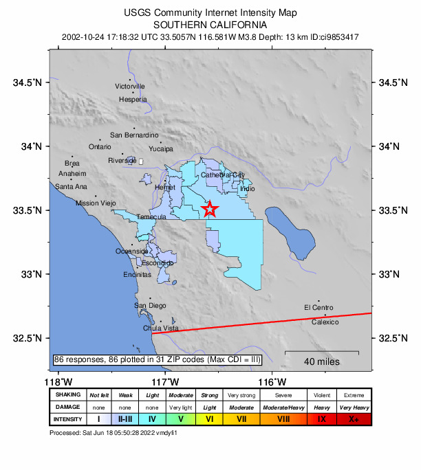
86 people reported to the USGS what they felt; the strongest reported shaking was III, weak shaking.
How well it is located
Reviewed by a seismologist.
- Location uncertainty
- About 0.2 km horizontally, 0.3 km in depth
- Magnitude uncertainty
- ±0.34
- Depth from
- From location
- Station coverage gap
- 22°
- Stations used
- 73
Nearest places
Distance and direction from each place to the epicenter, with its forecast.
Nearby
Within 100 km, magnitude 1.5 and up: 194 in the 60 days after this one and 112 in the 30 days before it.
After
- 2.010km ESE of Anza, CA · 8746 days ago · 14 km deep · 1 km away
- 1.911km ESE of Anza, CA · 8746 days ago · 14 km deep · 1 km away
- 2.311km ESE of Anza, CA · 8746 days ago · 14 km deep · 1 km away
- 1.511km ESE of Anza, CA · 8746 days ago · 15 km deep · 2 km away
- 2.410km ESE of Anza, CA · 8746 days ago · 13 km deep · 2 km away
- 2.510km ESE of Anza, CA · 8746 days ago · 13 km deep · 1 km away
- 2.010km ESE of Anza, CA · 8746 days ago · 14 km deep · 1 km away
- 2.17km ESE of Bombay Beach, CA · 8746 days ago · 11 km deep · 87 km away
- 2.216km S of Salton City, California · 8746 days ago · 9 km deep · 70 km away
- 1.610km ESE of Anza, CA · 8746 days ago · 13 km deep · 1 km away
- 1.611km ESE of Anza, California · 8746 days ago · 15 km deep · 2 km away
- 1.510km ESE of Anza, CA · 8746 days ago · 13 km deep · 1 km away
- 2.110km SE of Valle Vista, CA · 8746 days ago · 16 km deep · 30 km away
- 2.210km ESE of Anza, CA · 8745 days ago · 13 km deep · 0 km away
- 1.510km ESE of Anza, CA · 8745 days ago · 15 km deep · 2 km away
- 1.67km SSW of Idyllwild, CA · 8744 days ago · 16 km deep · 25 km away
- 1.910km NNW of Idyllwild, CA · 8744 days ago · 16 km deep · 39 km away
- 1.58km NNW of Lake Henshaw, CA · 8743 days ago · 5 km deep · 29 km away
- 2.010km SW of Idyllwild, CA · 8742 days ago · 16 km deep · 27 km away
- 1.56km SE of Julian, CA · 8742 days ago · 14 km deep · 53 km away
- 2.16km SE of Julian, CA · 8742 days ago · 14 km deep · 52 km away
- 2.06km SW of Idyllwild, California · 8742 days ago · 16 km deep · 28 km away
- 1.913km SSE of Big Bear City, CA · 8742 days ago · 10 km deep · 75 km away
- 1.67km N of Moreno Valley, California · 8742 days ago · 8 km deep · 80 km away
- 1.73km SSE of Hemet, CA · 8742 days ago · 15 km deep · 42 km away
- 1.83km ESE of Hemet, CA · 8742 days ago · 12 km deep · 42 km away
- 1.63km SSW of Salton City, CA · 8742 days ago · 5 km deep · 63 km away
- 2.810km N of Borrego Springs, CA · 8741 days ago · 13 km deep · 27 km away
- 1.626km ENE of Pine Valley, CA · 8741 days ago · 5 km deep · 76 km away
- 2.78km NE of Pala, CA · 8741 days ago · 13 km deep · 42 km away
- 2.37km WNW of Desert Hot Springs, CA · 8741 days ago · 11 km deep · 52 km away
- 1.812km ENE of Indio, CA · 8740 days ago · 10 km deep · 54 km away
- 1.56km NE of Cabazon, California · 8740 days ago · 16 km deep · 52 km away
- 1.513km ESE of Anza, CA · 8740 days ago · 9 km deep · 3 km away
- 1.61km SE of La Quinta, CA · 8740 days ago · 8 km deep · 31 km away
- 1.77km SE of Valle Vista, CA · 8740 days ago · 15 km deep · 32 km away
- 1.82km NNE of Grand Terrace, CA · 8740 days ago · 13 km deep · 90 km away
- 1.518km ENE of Borrego Springs, CA · 8740 days ago · 10 km deep · 42 km away
- 2.26km NW of Big Bear City, CA · 8740 days ago · 6 km deep · 93 km away
- 2.410km NNE of Ocotillo Wells, CA · 8740 days ago · 13 km deep · 54 km away
- 1.78km SSW of Idyllwild, CA · 8739 days ago · 15 km deep · 23 km away
- 1.78km N of Big Bear City, CA · 8739 days ago · 2 km deep · 95 km away
- 3.112km NW of Aguanga, CA · 8739 days ago · 5 km deep · 33 km away
- 1.713km NNW of Aguanga, CA · 8739 days ago · 7 km deep · 33 km away
- 1.56km N of Yucca Valley, CA · 8739 days ago · 9 km deep · 74 km away
- 2.212km WNW of Calipatria, CA · 8738 days ago · 6 km deep · 96 km away
- 2.010km WNW of Calipatria, CA · 8738 days ago · 9 km deep · 98 km away
- 1.911km N of Borrego Springs, CA · 8738 days ago · 13 km deep · 25 km away
- 1.79km ESE of Borrego Springs, CA · 8738 days ago · 7 km deep · 41 km away
- 1.54km NE of Cabazon, CA · 8738 days ago · 12 km deep · 51 km away
- 2.012km NW of Aguanga, CA · 8738 days ago · 7 km deep · 33 km away
- 1.920km ESE of Ocotillo Wells, CA · 8737 days ago · 11 km deep · 77 km away
- 1.811km SE of Anza, CA · 8737 days ago · 11 km deep · 3 km away
- 1.921km NNE of Pine Valley, CA · 8737 days ago · 10 km deep · 61 km away
- 1.69km ESE of Valle Vista, CA · 8737 days ago · 16 km deep · 31 km away
- 1.56km SSE of Loma Linda, CA · 8737 days ago · 14 km deep · 82 km away
- 1.812km WNW of Calipatria, CA · 8736 days ago · 4 km deep · 96 km away
- 3.313km WNW of Calipatria, CA · 8736 days ago · 2 km deep · 95 km away
- 3.012km WNW of Calipatria, CA · 8736 days ago · 3 km deep · 96 km away
- 2.512km WNW of Calipatria, California · 8736 days ago · 2 km deep · 96 km away
The first 60 of 194.
Before
- 1.76km SE of Big Bear Lake, CA · 8746 days ago · 3 km deep · 82 km away
- 1.72km NNE of Ocotillo Wells, CA · 8746 days ago · 9 km deep · 57 km away
- 1.517km ESE of Anza, CA · 8746 days ago · 10 km deep · 7 km away
- 1.96km NW of Big Bear City, CA · 8746 days ago · 6 km deep · 93 km away
- 1.61km NE of Loma Linda, California · 8747 days ago · 13 km deep · 87 km away
- 1.86km NW of Big Bear City, CA · 8747 days ago · 6 km deep · 92 km away
- 1.619km ESE of Anza, CA · 8747 days ago · 15 km deep · 10 km away
- 1.810km SE of Valle Vista, CA · 8747 days ago · 16 km deep · 30 km away
- 2.35km NW of Big Bear City, CA · 8747 days ago · 6 km deep · 92 km away
- 1.85km NW of Big Bear City, CA · 8747 days ago · 4 km deep · 92 km away
- 1.66km NW of Big Bear City, CA · 8747 days ago · 6 km deep · 93 km away
- 1.55km NW of Big Bear City, California · 8747 days ago · 5 km deep · 92 km away
- 1.55km N of Beaumont, CA · 8747 days ago · 17 km deep · 64 km away
- 1.89km NNE of Ocotillo Wells, CA · 8748 days ago · 5 km deep · 54 km away
- 1.89km SW of Niland, California · 8748 days ago · 4 km deep · 98 km away
- 1.59km SW of Niland, California · 8748 days ago · 3 km deep · 98 km away
- 1.618km SSW of Oasis, CA · 8748 days ago · 8 km deep · 42 km away
- 1.86km NW of Big Bear City, CA · 8748 days ago · 6 km deep · 93 km away
- 3.66km NW of Big Bear City, CA · 8748 days ago · 5 km deep · 93 km away · felt by 101
- 1.623km ESE of Anza, CA · 8749 days ago · 9 km deep · 13 km away
Earthquakes todayCalifornia earthquakesLive radar here
Sources
From the USGS Earthquake Hazards Program and its partner networks, event ci9853417 (also filed as ci09853417, usp000bf8y). Read Sun, Oct 4, 2026, 3:21 PM UTC.