M5.8 earthquake 39 km SSE of Puli, Taiwan
A magnitude 5.8 earthquake struck 39 km SSE of Puli, Taiwan on Wed, Sep 22, 1999, 8:49 AM GMT+8 (00:49 UTC), 33 km (21 mi) below the surface.
A larger quake followed: M6.5 31 km SE of Puli, Taiwan. This one was a foreshock.
Map
Where this earthquake was located, with the others nearby. Select one for its page.
The earthquake
- Magnitude
- 5.8 (mwc), moderate
- Local time
- UTC
- 1999-09-22 00:49:42 UTC
- Depth
- 33.0 km (20.5 mi), shallow
- Epicenter
- 23.642° N, 121.136° E
- Region
- Taiwan
- Strongest shaking
- V, moderate shaking
- Tsunami flag
- No
- Status
- Reviewed by a seismologist
Shaking
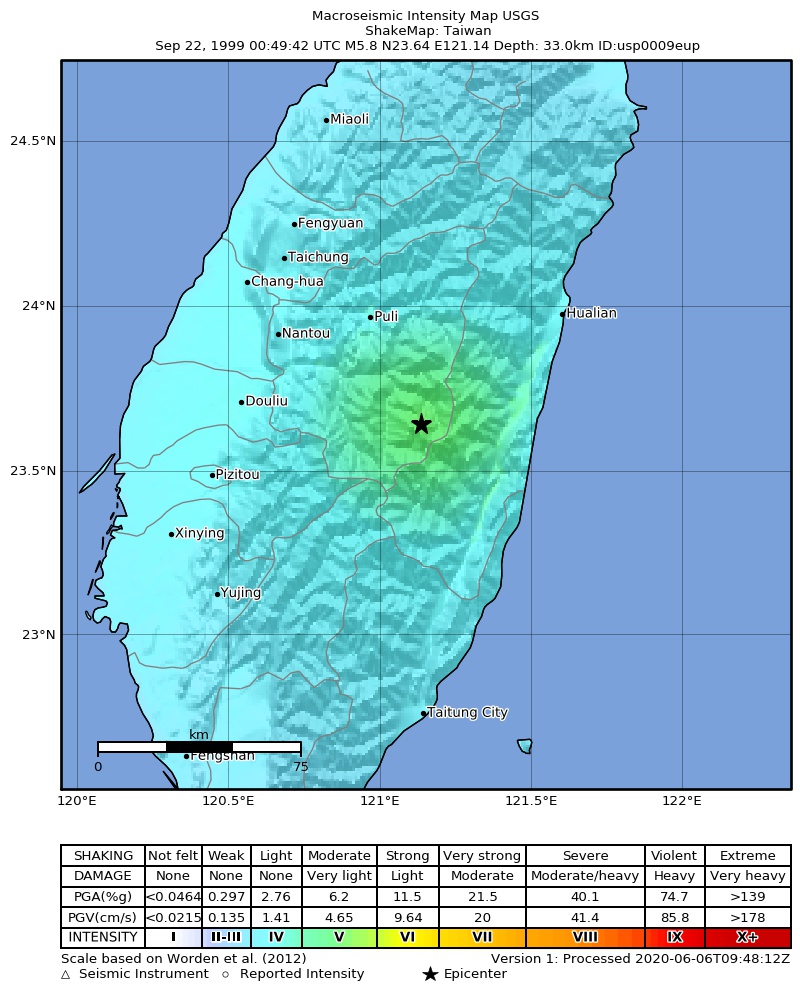
The USGS ShakeMap: shaking estimated from seismic stations and the quake’s size, on the Modified Mercalli intensity scale.
- Strongest estimated
- V, moderate shaking
- Peak ground acceleration
- 8.6% of gravity
- Peak ground velocity
- 1.6 cm/s
- Map
- Automatic
Did you feel it?
No one has reported feeling this quake to the USGS.
Fault motion and ground failure
How the rock slipped, from the moment tensor, and the USGS estimate of landslides and liquefaction.
- Faulting
- Reverse (thrust)
- Nodal plane 1
- Strike 3°, dip 25°, rake 97°
- Nodal plane 2
- Strike 175°, dip 65°, rake 87°
How well it is located
Reviewed by a seismologist.
- Depth from
- OPERATOR_ASSIGNED
Nearest places
Distance and direction from each place to the epicenter, with its forecast.
Nearby
Within 100 km, magnitude 2.8 and up: 111 in the 60 days after this one and 74 in the 30 days before it.
After
- 4.239 km SSE of Puli, Taiwan · 9870 days ago · 33 km deep · 1 km away
- 4.927 km SSW of Hualien City, Taiwan · 9870 days ago · 33 km deep · 37 km away
- 4.421 km S of Lugu, Taiwan · 9870 days ago · 33 km deep · 37 km away
- 4.636 km SSE of Puli, Taiwan · 9870 days ago · 33 km deep · 4 km away
- 3.811 km SE of Hualien City, Taiwan · 9869 days ago · 33 km deep · 64 km away
- 5.340 km ESE of Lugu, Taiwan · 9869 days ago · 33 km deep · 6 km away
- 4.519 km SSE of Lugu, Taiwan · 9869 days ago · 33 km deep · 31 km away
- 4.221 km NE of Hualien City, Taiwan · 9869 days ago · 33 km deep · 82 km away
- 4.022 km ENE of Puli, Taiwan · 9869 days ago · 33 km deep · 46 km away
- 4.55 km SSW of Hualien City, Taiwan · 9869 days ago · 33 km deep · 55 km away
- 4.426 km SSW of Hualien City, Taiwan · 9869 days ago · 33 km deep · 37 km away
- 4.836 km NE of Puli, Taiwan · 9869 days ago · 20 km deep · 64 km away
- 4.52 km E of Puli, Taiwan · 9868 days ago · 21 km deep · 39 km away
- 5.334 km ESE of Puli, Taiwan · 9868 days ago · 33 km deep · 23 km away
- 4.625 km SE of Puli, Taiwan · 9868 days ago · 33 km deep · 21 km away
- 4.550 km NW of Hualien City, Taiwan · 9868 days ago · 33 km deep · 80 km away
- 4.114 km SSE of Lugu, Taiwan · 9868 days ago · 3 km deep · 34 km away
- 5.022 km W of Hualien City, Taiwan · 9868 days ago · 16 km deep · 45 km away
- 4.516 km S of Hualien City, Taiwan · 9868 days ago · 33 km deep · 50 km away
- 4.237 km NNE of Puli, Taiwan · 9868 days ago · 33 km deep · 73 km away
- 3.623 km ENE of Puli, Taiwan · 9867 days ago · 33 km deep · 49 km away
- 3.75 km NNW of Lugu, Taiwan · 9867 days ago · 33 km deep · 45 km away
- 4.338 km ESE of Lugu, Taiwan · 9867 days ago · 33 km deep · 5 km away
- 4.79 km S of Hualien City, Taiwan · 9867 days ago · 33 km deep · 54 km away
- 4.335 km NW of Hualien City, Taiwan · 9866 days ago · 33 km deep · 70 km away
- 5.150 km ESE of Lugu, Taiwan · 9866 days ago · 33 km deep · 12 km away
- 4.429 km W of Hualien City, Taiwan · 9866 days ago · 33 km deep · 37 km away
- 4.544 km E of Yujing, Taiwan · 9866 days ago · 33 km deep · 58 km away
- 4.635 km SE of Lugu, Taiwan · 9866 days ago · 33 km deep · 21 km away
- 6.531 km SE of Puli, Taiwan · 9866 days ago · 17 km deep · 11 km away
- 4.041 km ESE of Lugu, Taiwan · 9865 days ago · 33 km deep · 7 km away
- 3.931 km NNE of Hualien City, Taiwan · 9865 days ago · 33 km deep · 90 km away
- 4.77 km NNW of Hualien City, Taiwan · 9865 days ago · 33 km deep · 64 km away
- 4.736 km WNW of Hualien City, Taiwan · 9865 days ago · 33 km deep · 57 km away
- 4.821 km ENE of Puli, Taiwan · 9864 days ago · 33 km deep · 43 km away
- 4.912 km E of Puli, Taiwan · 9864 days ago · 33 km deep · 35 km away
- 5.335 km SSW of Hualien City, Taiwan · 9864 days ago · 33 km deep · 39 km away
- 4.631 km S of Hualien City, Taiwan · 9864 days ago · 33 km deep · 45 km away
- 3.430 km ESE of Lugu, Taiwan · 9864 days ago · 33 km deep · 11 km away
- 4.216 km WNW of Hualien City, Taiwan · 9864 days ago · 33 km deep · 53 km away
- 4.235 km NNE of Puli, Taiwan · 9863 days ago · 33 km deep · 66 km away
- 4.66 km NE of Zhongxing New Village, Taiwan · 9863 days ago · 33 km deep · 59 km away
- 4.666 km E of Yujing, Taiwan · 9863 days ago · 33 km deep · 60 km away
- 3.928 km ESE of Puli, Taiwan · 9863 days ago · 33 km deep · 32 km away
- 4.10 km ESE of Lugu, Taiwan · 9863 days ago · 33 km deep · 40 km away
- 4.643 km NE of Puli, Taiwan · 9862 days ago · 33 km deep · 73 km away
- 4.324 km SE of Lugu, Taiwan · 9861 days ago · 9 km deep · 26 km away
- 4.513 km E of Yujing, Taiwan · 9861 days ago · 33 km deep · 80 km away
- 4.117 km SSE of Puli, Taiwan · 9861 days ago · 33 km deep · 22 km away
- 5.231 km ESE of Lugu, Taiwan · 9860 days ago · 33 km deep · 11 km away
- 4.543 km SSE of Puli, Taiwan · 9860 days ago · 33 km deep · 4 km away
- 3.638 km SE of Puli, Taiwan · 9860 days ago · 33 km deep · 15 km away
- 4.46 km S of Hualien City, Taiwan · 9860 days ago · 33 km deep · 56 km away
- 4.340 km SE of Puli, Taiwan · 9859 days ago · 33 km deep · 18 km away
- 4.924 km SSE of Lugu, Taiwan · 9858 days ago · 9 km deep · 28 km away
- 4.928 km ESE of Lugu, Taiwan · 9857 days ago · 33 km deep · 16 km away
- 3.916 km WSW of Hualien City, Taiwan · 9857 days ago · 33 km deep · 46 km away
- 3.740 km E of Yujing, Taiwan · 9857 days ago · 33 km deep · 69 km away
- 4.832 km SSE of Puli, Taiwan · 9856 days ago · 33 km deep · 7 km away
- 3.472 km ESE of Yujing, Taiwan · 9856 days ago · 33 km deep · 84 km away
The first 60 of 111.
Before
- 4.415 km E of Puli, Taiwan · 9870 days ago · 33 km deep · 34 km away
- 4.650 km ESE of Lugu, Taiwan · 9870 days ago · 33 km deep · 12 km away
- 6.433 km SE of Puli, Taiwan · 9870 days ago · 26 km deep · 10 km away
- 5.127 km SW of Hualien City, Taiwan · 9870 days ago · 33 km deep · 34 km away
- 4.323 km S of Lugu, Taiwan · 9870 days ago · 33 km deep · 43 km away
- 4.510 km ENE of Lugu, Taiwan · 9870 days ago · 33 km deep · 32 km away
- 5.221 km ENE of Puli, Taiwan · 9870 days ago · 33 km deep · 46 km away
- 5.234 km WSW of Hualien City, Taiwan · 9870 days ago · 14 km deep · 26 km away
- 4.227 km NNE of Taichung, Taiwan · 9870 days ago · 33 km deep · 86 km away
- 4.334 km WSW of Hualien City, Taiwan · 9870 days ago · 33 km deep · 27 km away
- 4.639 km SE of Lugu, Taiwan · 9870 days ago · 33 km deep · 14 km away
- 4.0Taiwan · 9870 days ago · 33 km deep · 62 km away
- 4.319 km SW of Hualien City, Taiwan · 9870 days ago · 33 km deep · 41 km away
- 4.132 km SE of Puli, Taiwan · 9870 days ago · 33 km deep · 19 km away
- 3.8Taiwan · 9870 days ago · 33 km deep · 60 km away
- 4.16 km NW of Pizitou, Taiwan · 9870 days ago · 33 km deep · 77 km away
- 4.632 km ESE of Lugu, Taiwan · 9870 days ago · 33 km deep · 13 km away
- 3.733 km ESE of Lugu, Taiwan · 9870 days ago · 33 km deep · 7 km away
- 4.213 km SE of Douliu, Taiwan · 9870 days ago · 33 km deep · 51 km away
- 4.125 km S of Lugu, Taiwan · 9870 days ago · 33 km deep · 38 km away
Earthquakes todayTaiwan earthquakesLive radar here
Sources
From the USGS Earthquake Hazards Program and its partner networks, event usp0009eup (also filed as gcmtc092299b, gcmt19990922004942, atlas19990922004943, iscgem1656276). Read Tue, Sep 29, 2026, 4:35 PM UTC.