M6.0 earthquake 5 km WNW of Fylí, Greece
A magnitude 6.0 earthquake struck 5 km WNW of Fylí, Greece on Tue, Sep 7, 1999, 2:56 PM GMT+3 (11:56 UTC), 10 km (6 mi) below the surface.
Map
Where this earthquake was located, with the others nearby. Select one for its page.
The earthquake
- Magnitude
- 6.0 (Mwc, centroid moment), strong
- Magnitude from
- USGS National Earthquake Information Center
- Local time
- UTC
- 1999-09-07 11:56:49 UTC
- Depth
- 10.0 km (6.2 mi), shallow
- Epicenter
- 38.119° N, 23.605° E
- Region
- Greece
- Strongest shaking
- IX, violent shaking
- Tsunami flag
- No
- Status
- Reviewed by a seismologist
Magnitude estimates
Different scales measure different things and differ by a few tenths. The USGS marks one as preferred, and it is the one this page uses.
| Mag. | Scale | Computed by | Notes |
|---|---|---|---|
| 6.0 | Mwc, centroid moment | USGS National Earthquake Information Center | Preferred · Reviewed |
| 5.98 | Mw, moment | ISC-GEM global catalog | Final · ±0.1 |
| 6.0 | Mwc, centroid moment | Global CMT project | Preliminary |
| 5.65 | Me, energy | Choy, USGS energy magnitude | Reviewed |
Deaths and damage
From NOAA NCEI’s Significant Earthquake Database (record 5531), matched to this event by time and place.
- Deaths
- 143
- Injuries
- 1,600
- Damage
- $4.2 billion
- Houses destroyed
- 53,000
Where the literature gives no number, NCEI records a description on a scale of 1 to 4, printed here in its words. Damage is in millions of US dollars of the year of the event, not adjusted for inflation.
From Wikipedia
The 1999 Athens earthquake occurred on September 7 at 14:56:51 local time near Mount Parnitha in Greece with a moment magnitude of 6.0 and a maximum Mercalli intensity of IX (Violent). The proximity to the Athens metropolitan area resulted in widespread structural damage, mainly to the nearby suburban towns of Ano Liosia, Acharnes, Fyli, Thrakomakedones, Kifissia, Metamorfosi, Kamatero and Nea Filadelfeia. More than 100 buildings (including three major factories) across those areas collapsed trapping scores of victims under their rubble while dozens more were severely damaged. With damage estimated at $3–4.2 billion, 143 people were killed, and up to 1,600 were treated for injuries in Greece's deadliest natural disaster in almost half a century.
Text from Wikipedia, “1999 Athens earthquake”, licensed CC BY-SA 4.0. Quoted as written; the full article has the rest.
The article is about the earthquake NOAA’s record describes, matched to this one by date, place and magnitude.
What happened
The USGS’s account of the effects of this earthquake.
One hundred forty-three people killed, 1,600 injured, 50,000 homeless and at least 53,000 buildings damaged or destroyed (IX) in the Athens area. Preliminary estimate of damage at 655 million U.S. dollars. Felt in much of central Greece and as far as Izmir, Turkey.
From the USGS event page for usp0009e46. U.S. Geological Survey text and figures are in the public domain.
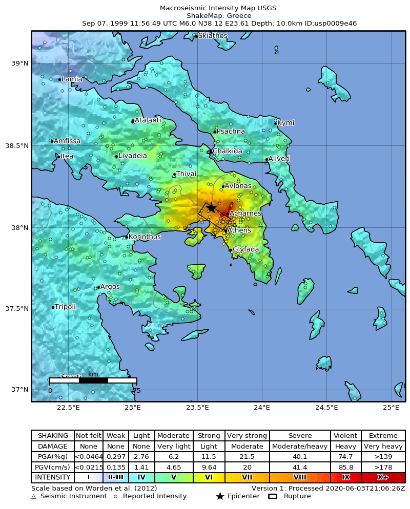
Shaking
The USGS ShakeMap: shaking estimated from seismic stations and the quake’s size, on the Modified Mercalli intensity scale.
- Strongest estimated
- IX, violent shaking
- Peak ground acceleration
- 92.7% of gravity
- Peak ground velocity
- 4.4 cm/s
- Map
- Automatic
Did you feel it?
No one has reported feeling this quake to the USGS.
Fault motion and ground failure
How the rock slipped, from the moment tensor, and the USGS estimate of landslides and liquefaction.
- Faulting
- Normal
- Nodal plane 1
- Strike 116°, dip 39°, rake -81°
- Nodal plane 2
- Strike 284°, dip 52°, rake -98°
- Landslide alert
- Yellow
- Liquefaction alert
- Yellow
How well it is located
Reviewed by a seismologist.
- Depth from
- OPERATOR_ASSIGNED
Nearest places
Distance and direction from each place to the epicenter, with its forecast.
Nearby
Within 100 km, magnitude 3.0 and up: 22 in the 60 days after this one and 1 in the 30 days before it.
After
- 4.40 km SE of Thrakomakedónes, Greece · 9889 days ago · 10 km deep · 14 km away
- 4.33 km NNW of Lykóvrysi, Greece · 9889 days ago · 10 km deep · 15 km away
- 4.02 km NW of Fylí, Greece · 9889 days ago · 10 km deep · 3 km away
- 4.31 km ESE of Paianía, Greece · 9889 days ago · 10 km deep · 30 km away
- 4.22 km NW of Athens, Greece · 9889 days ago · 10 km deep · 16 km away
- 4.22 km NNW of Chaïdári, Greece · 9889 days ago · 10 km deep · 11 km away
- 4.22 km SE of Karellás, Greece · 9889 days ago · 10 km deep · 33 km away
- 3.91 km NNW of Kipséli, Greece · 9889 days ago · 10 km deep · 16 km away
- 4.12 km S of Elefsína, Greece · 9888 days ago · 10 km deep · 12 km away
- 4.60 km NNE of Petroúpolis, Greece · 9888 days ago · 10 km deep · 11 km away
- 3.93 km W of Afidnés, Greece · 9888 days ago · 10 km deep · 19 km away
- 3.90 km S of Ágioi Anárgyroi, Greece · 9888 days ago · 10 km deep · 14 km away
- 4.41 km WSW of Petroúpolis, Greece · 9888 days ago · 10 km deep · 11 km away
- 4.01 km SE of Skarmagkás, Greece · 9888 days ago · 10 km deep · 13 km away
- 4.30 km SE of Kamaterón, Greece · 9888 days ago · 10 km deep · 12 km away
- 4.21 km NW of Chaïdári, Greece · 9886 days ago · 10 km deep · 12 km away
- 3.90 km N of Metamórfosi, Greece · 9884 days ago · 10 km deep · 15 km away
- 4.32 km NNE of Magoúla, Greece · 9873 days ago · 22 km deep · 6 km away
- 4.11 km WSW of Piraeus, Greece · 9870 days ago · 10 km deep · 21 km away
- 4.614 km SSW of Kaparéllion, Greece · 9843 days ago · 33 km deep · 37 km away
- 3.92 km NNE of Asprópyrgos, Greece · 9839 days ago · 33 km deep · 4 km away
- 4.211 km SSW of Áyios Thomás, Greece · 9836 days ago · 5 km deep · 11 km away
Before
Earthquakes todayGreece earthquakesLive radar here
Sources
From the USGS Earthquake Hazards Program and its partner networks, event usp0009e46 (also filed as choy19990907115649, gcmtb090799c, gcmt19990907115649, atlas19990907115649, iscgem1655758). Read Sun, Oct 4, 2026, 7:36 AM UTC.