M7.3 earthquake 46 km SSW of Adak, Alaska
A magnitude 7.3 earthquake struck 46 km SSW of Adak, Alaska on Mon, Jun 10, 1996, 6:24 AM HADT (15:24 UTC), 26 km (16 mi) below the surface.
Map
Where this earthquake was located, with the others nearby. Select one for its page.
The earthquake
- Magnitude
- 7.3 (Mwc, centroid moment), major
- Magnitude from
- USGS National Earthquake Information Center
- Local time
- UTC
- 1996-06-10 15:24:56 UTC
- Depth
- 26.3 km (16.3 mi), shallow
- Epicenter
- 51.478° N, 176.847° W
- Region
- Alaska
- Strongest shaking
- VII, very strong shaking
- Tsunami flag
- No
- Status
- Reviewed by a seismologist
Magnitude estimates
Different scales measure different things and differ by a few tenths. The USGS marks one as preferred, and it is the one this page uses.
| Mag. | Scale | Computed by | Notes |
|---|---|---|---|
| 7.3 | Mwc, centroid moment | USGS National Earthquake Information Center | Preferred · Reviewed |
| 7.23 | Mw, moment | ISC-GEM global catalog | Final · ±0.1 |
| 7.2 | Mwc, centroid moment | Global CMT project | Preliminary |
| 6.87 | Me, energy | Choy, USGS energy magnitude | Reviewed |
| 7.2 | Mww, W-phase moment | Duputel, W-phase inversion | Preliminary |
| 7.2 | Mw, moment | Alaska Earthquake Center | Preliminary |
Deaths and damage
From NOAA NCEI’s Significant Earthquake Database (record 6498), matched to this event by time and place.
NOAA’s record of this earthquake gives no deaths, injuries or damage.
What happened
The USGS’s account of the effects of this earthquake.
Felt strongly on Adak.
From the USGS event page for usp0007jfz. U.S. Geological Survey text and figures are in the public domain.
Shaking
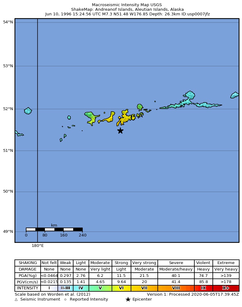
The USGS ShakeMap: shaking estimated from seismic stations and the quake’s size, on the Modified Mercalli intensity scale.
- Strongest estimated
- VII, very strong shaking
- Peak ground acceleration
- 28.1% of gravity
- Peak ground velocity
- 3.2 cm/s
- Map
- Automatic
Did you feel it?
No one has reported feeling this quake to the USGS.
Fault motion and ground failure
How the rock slipped, from the moment tensor, and the USGS estimate of landslides and liquefaction.
- Faulting
- Reverse (thrust)
- Moment magnitude
- 7.2 Mww
- Nodal plane 1
- Strike 260°, dip 25°, rake 105°
- Nodal plane 2
- Strike 63°, dip 65°, rake 82°
How well it is located
Reviewed by a seismologist.
- Depth from
- OPERATOR_ASSIGNED
Nearby
Within 100 km, magnitude 4.3 and up: 74 in the 60 days after this one and 56 in the 30 days before it.
After
- 5.577 km S of Adak, Alaska · 11072 days ago · 33 km deep · 34 km away
- 4.662 km S of Adak, Alaska · 11072 days ago · 33 km deep · 30 km away
- 4.598 km SSE of Adak, Alaska · 11072 days ago · 33 km deep · 65 km away
- 4.733 km WSW of Adak, Alaska · 11072 days ago · 33 km deep · 30 km away
- 4.467 km S of Adak, Alaska · 11072 days ago · 33 km deep · 23 km away
- 5.643 km SW of Adak, Alaska · 11072 days ago · 33 km deep · 17 km away
- 4.475 km S of Adak, Alaska · 11072 days ago · 33 km deep · 38 km away
- 4.5127 km SW of Adak, Alaska · 11072 days ago · 33 km deep · 90 km away
- 4.391 km WSW of Adak, Alaska · 11072 days ago · 33 km deep · 70 km away
- 4.760 km SSW of Adak, Alaska · 11072 days ago · 33 km deep · 15 km away
- 4.748 km SSE of Adak, Alaska · 11072 days ago · 33 km deep · 26 km away
- 4.867 km S of Adak, Alaska · 11072 days ago · 33 km deep · 35 km away
- 4.4Andreanof Islands, Aleutian Islands, Alaska · 11072 days ago · 33 km deep · 51 km away
- 4.552 km S of Adak, Alaska · 11072 days ago · 33 km deep · 14 km away
- 4.586 km S of Adak, Alaska · 11072 days ago · 33 km deep · 47 km away
- 4.474 km SSE of Adak, Alaska · 11072 days ago · 33 km deep · 42 km away
- 4.581 km SSE of Adak, Alaska · 11071 days ago · 33 km deep · 48 km away
- 4.480 km SSW of Adak, Alaska · 11071 days ago · 33 km deep · 34 km away
- 4.391 km S of Adak, Alaska · 11071 days ago · 33 km deep · 50 km away
- 4.392 km SSE of Adak, Alaska · 11071 days ago · 33 km deep · 64 km away
- 4.384 km S of Adak, Alaska · 11071 days ago · 33 km deep · 47 km away
- 4.785 km SSE of Adak, Alaska · 11071 days ago · 33 km deep · 61 km away
- 4.3100 km SSW of Adak, Alaska · 11071 days ago · 33 km deep · 55 km away
- 4.476 km SSE of Adak, Alaska · 11071 days ago · 33 km deep · 60 km away
- 5.971 km SSE of Adak, Alaska · 11071 days ago · 33 km deep · 47 km away
- 4.371 km SSE of Adak, Alaska · 11071 days ago · 33 km deep · 53 km away
- 4.866 km SSE of Adak, Alaska · 11071 days ago · 33 km deep · 35 km away
- 4.968 km SSE of Adak, Alaska · 11071 days ago · 33 km deep · 46 km away
- 5.873 km SSE of Adak, Alaska · 11071 days ago · 33 km deep · 51 km away
- 4.572 km SSE of Adak, Alaska · 11071 days ago · 33 km deep · 54 km away
- 4.540 km SSW of Adak, Alaska · 11071 days ago · 33 km deep · 6 km away
- 5.669 km S of Adak, Alaska · 11071 days ago · 33 km deep · 36 km away
- 4.4121 km SW of Adak, Alaska · 11071 days ago · 33 km deep · 81 km away
- 4.377 km S of Adak, Alaska · 11071 days ago · 33 km deep · 43 km away
- 4.581 km SSE of Adak, Alaska · 11071 days ago · 33 km deep · 60 km away
- 4.7100 km SW of Adak, Alaska · 11071 days ago · 33 km deep · 69 km away
- 4.553 km SSE of Adak, Alaska · 11071 days ago · 33 km deep · 38 km away
- 5.8120 km WSW of Adak, Alaska · 11070 days ago · 33 km deep · 95 km away
- 5.5123 km WSW of Adak, Alaska · 11070 days ago · 33 km deep · 96 km away
- 4.758 km SW of Adak, Alaska · 11070 days ago · 33 km deep · 29 km away
- 4.450 km SSW of Adak, Alaska · 11070 days ago · 33 km deep · 4 km away
- 4.764 km SSE of Adak, Alaska · 11070 days ago · 33 km deep · 37 km away
- 4.858 km SSE of Adak, Alaska · 11070 days ago · 33 km deep · 40 km away
- 4.5104 km SW of Adak, Alaska · 11070 days ago · 33 km deep · 68 km away
- 5.678 km SSE of Adak, Alaska · 11070 days ago · 33 km deep · 58 km away
- 4.686 km SSE of Adak, Alaska · 11070 days ago · 33 km deep · 52 km away
- 4.671 km SSE of Adak, Alaska · 11070 days ago · 33 km deep · 49 km away
- 4.783 km WSW of Adak, Alaska · 11069 days ago · 33 km deep · 62 km away
- 4.548 km SSW of Adak, Alaska · 11069 days ago · 33 km deep · 3 km away
- 4.5104 km WSW of Adak, Alaska · 11069 days ago · 33 km deep · 77 km away
- 4.471 km SSE of Adak, Alaska · 11068 days ago · 33 km deep · 41 km away
- 4.845 km SSW of Adak, Alaska · 11068 days ago · 33 km deep · 2 km away
- 4.667 km SSE of Adak, Alaska · 11067 days ago · 33 km deep · 40 km away
- 4.771 km SSE of Adak, Alaska · 11067 days ago · 33 km deep · 45 km away
- 5.055 km SSW of Adak, Alaska · 11066 days ago · 33 km deep · 10 km away
- 5.1126 km WSW of Adak, Alaska · 11065 days ago · 33 km deep · 98 km away
- 4.564 km SW of Adak, Alaska · 11064 days ago · 33 km deep · 28 km away
- 4.595 km WSW of Adak, Alaska · 11063 days ago · 33 km deep · 67 km away
- 4.883 km WSW of Adak, Alaska · 11063 days ago · 33 km deep · 61 km away
- 4.359 km SW of Adak, Alaska · 11061 days ago · 45 km deep · 27 km away
The first 60 of 74.
Before
- 4.4109 km SSW of Adak, Alaska · 11072 days ago · 33 km deep · 65 km away
- 5.265 km SW of Adak, Alaska · 11072 days ago · 33 km deep · 32 km away
- 4.877 km SSE of Adak, Alaska · 11072 days ago · 33 km deep · 46 km away
- 5.047 km SW of Adak, Alaska · 11072 days ago · 33 km deep · 16 km away
- 5.049 km SSW of Adak, Alaska · 11072 days ago · 33 km deep · 4 km away
- 4.386 km SSE of Adak, Alaska · 11072 days ago · 33 km deep · 61 km away
- 4.486 km WSW of Adak, Alaska · 11072 days ago · 33 km deep · 62 km away
- 5.2118 km WSW of Adak, Alaska · 11072 days ago · 33 km deep · 87 km away
- 4.460 km SSW of Adak, Alaska · 11072 days ago · 33 km deep · 15 km away
- 4.6129 km SW of Adak, Alaska · 11072 days ago · 33 km deep · 92 km away
- 4.8131 km SW of Adak, Alaska · 11072 days ago · 33 km deep · 94 km away
- 4.790 km SSW of Adak, Alaska · 11072 days ago · 33 km deep · 46 km away
- 4.9118 km WSW of Adak, Alaska · 11072 days ago · 33 km deep · 99 km away
- 4.3125 km WSW of Adak, Alaska · 11072 days ago · 33 km deep · 94 km away
- 4.7106 km SW of Adak, Alaska · 11072 days ago · 33 km deep · 71 km away
- 4.364 km S of Adak, Alaska · 11072 days ago · 33 km deep · 26 km away
- 5.0127 km WSW of Adak, Alaska · 11072 days ago · 33 km deep · 98 km away
- 4.590 km S of Adak, Alaska · 11072 days ago · 33 km deep · 54 km away
- 5.674 km S of Adak, Alaska · 11072 days ago · 33 km deep · 39 km away
- 5.277 km SSE of Adak, Alaska · 11072 days ago · 33 km deep · 45 km away
Earthquakes todayAlaska earthquakesLive radar here
Sources
From the USGS Earthquake Hazards Program and its partner networks, event usp0007jfz (also filed as choy19960610152456, gcmtc061096s, gcmt19960610152456, duputel061096s, ak9967g64zlm, iscgem968793, atlas19960610152458). Read Sat, Oct 3, 2026, 9:29 AM UTC.