M7.2 earthquake 27 km SSE of Nuwaybi‘a, Egypt
A magnitude 7.2 earthquake struck 27 km SSE of Nuwaybi‘a, Egypt on Wed, Nov 22, 1995, 7:15 AM GMT+3 (04:15 UTC), 10 km (6 mi) below the surface.
Map
Where this earthquake was located, with the others nearby. Select one for its page.
The earthquake
- Magnitude
- 7.2 (Mw, moment), major
- Magnitude from
- USGS National Earthquake Information Center
- Local time
- UTC
- 1995-11-22 04:15:11 UTC
- Depth
- 10.0 km (6.2 mi), shallow
- Epicenter
- 28.826° N, 34.799° E
- Region
- Egypt
- Strongest shaking
- IX, violent shaking
- Tsunami flag
- No
- Status
- Reviewed by a seismologist
Magnitude estimates
Different scales measure different things and differ by a few tenths. The USGS marks one as preferred, and it is the one this page uses.
| Mag. | Scale | Computed by | Notes |
|---|---|---|---|
| 7.2 | Mw, moment | USGS National Earthquake Information Center | Preferred · Reviewed |
| 7.18 | Mw, moment | ISC-GEM global catalog | Final · ±0.1 |
| 7.2 | Mwc, centroid moment | Global CMT project | Preliminary |
| 7.27 | Me, energy | Choy, USGS energy magnitude | Reviewed |
| 7.1 | Mww, W-phase moment | Duputel, W-phase inversion | Preliminary |
Deaths and damage
From NOAA NCEI’s Significant Earthquake Database (record 5426), matched to this event by time and place.
- Deaths
- 11
- Injuries
- 47
- Damage
- Moderate (about $1 to $5 million)
- Houses destroyed
- Few (about 1 to 50) with its tsunami and other effects
Where the literature gives no number, NCEI records a description on a scale of 1 to 4, printed here in its words. Damage is in millions of US dollars of the year of the event, not adjusted for inflation.
From Wikipedia
The 1995 Gulf of Aqaba earthquake (also known as Nuweiba earthquake) occurred on November 22 at 06:15 local time (04:15 UTC) and registered 7.3 on the Mw scale. The epicenter was located in the central segment of the Gulf of Aqaba, the narrow body of water that separates Egypt's Sinai Peninsula from the western border of Saudi Arabia. At least 8 people were killed and 30 were injured in the meizoseismal area.
The earthquake occurred along the Dead Sea Transform (DST) fault system, an active tectonic plate boundary with seismicity that is characterized by long-running quiescent periods with occasional large and damaging earthquakes, along with intermittent earthquake swarms. It was the strongest tectonic event in the area for many decades and caused injuries, damage, and deaths throughout the Levant and is also thought to have remotely triggered a series of small to moderate earthquakes 500 kilometers (310 mi) to the north of the epicenter. In the aftermath of the quake, several field investigations set out to determine the extent of any surface faulting, and the distribution of aftershocks was analyzed.
Text from Wikipedia, “1995 Gulf of Aqaba earthquake”, licensed CC BY-SA 4.0. Quoted as written; the full article has the rest.
The article is about the earthquake NOAA’s record describes, matched to this one by date, place and magnitude.
Wikidata records: 8 deaths and 30 injured. These are counts entered by Wikidata’s editors; they may differ from the official count, and this page never adds them to another figure. Q4115120, CC0.
What happened
The USGS’s account of the effects of this earthquake.
At least eight people killed and 30 injured in the epicentral region including two killed and 11 injured at Nuwaybi. Damage occurred in many parts of northeastern Egypt as far away as Cairo. One person was killed and two slightly injured at Al Bad, Saudi Arabia. Some damage occurred at Al Bad, Al Ula and Haql, Saudi Arabia. One person died of a heart attack, several people were injured and substantial damage, power outages and liquefaction occurred at Elat, Israel. Some damage also occurred at Jerusalem, Israel and Aqaba, Jordan. Felt from Sudan to Lebanon. Felt at Baghdad and Mosul, Iraq. Also felt by people in high-rise buildings at Limassol and Nicosia, Cyprus. Possible tsunami observed at Aqaba, Jordon. Complex event observed on broadband displacement seismograms. FAULT PLANE SOLUTION: P-Waves NP1:Strike=280 Dip=75 Slip=-161 NP2:Strike=185 Dip=72 Slip=-16 Principal Axes: (T) Plg=2 Azm=52 (P) Plg=24 Azm=143 Comment: The focal mechanism is well controlled and corresponds to strike-slip faulting with a moderate normal component. The preferred fault plane is not determined. RADIATED ENERGY No. of sta: 25 Focal mech. F Energy 2.0+0.4*10**15 Nm MOMENT TENSOR SOLUTION Dep 6 No. of sta: 38 Moment Tensor; Scale 10**19 Nm Mrr=-1.43 Mtt=-0.99 Mff=2.42 Mrt=3.00 Mrf=-0.15 Mtf=-3.28 Principal axes: (T) Val=4.92 Plg=17 Azm=53 (N) Val=0.00 Plg=48 Azm=304 (P) Val=-4.92 Plg=38 Azm=157 Best Double Couple:Mo=4.9*10**19 NP1:Strike=188 Dip=51 Slip=-17 NP2:Strike=289 Dip=77 Slip=-139 CENTROID, MOMENT TENSOR (HRV) Data Used: GSN M.W.: 59S,162C Centroid Location: Origin Time 04:15:26.2 0.1 Lat 29.07N 0.01 Lon 34.73E 0.01 Dep 18.4 0.4 Half-duration 11.0 Moment Tensor; Scale 10**19 Nm Mrr=-1.36 0.03 Mtt=-3.26 0.02 Mff=4.62 0.03 Mrt=3.89 0.21 Mrf=0.09 0.18 Mtf=-4.49 0.02 Principal Axes: (T) Val=6.97 Plg=12 Azm=62 (N) Val=0.48 Plg=56 Azm=314 (P) Val=-7.45 Plg=31 Azm=159 Best Double Couple:Mo=7.2*10**19 NP1:Strike=196 Dip=59 Slip=-15 NP2:Strike=294 Dip=77 Slip=-149
From the USGS event page for usp0007788. U.S. Geological Survey text and figures are in the public domain.
Shaking
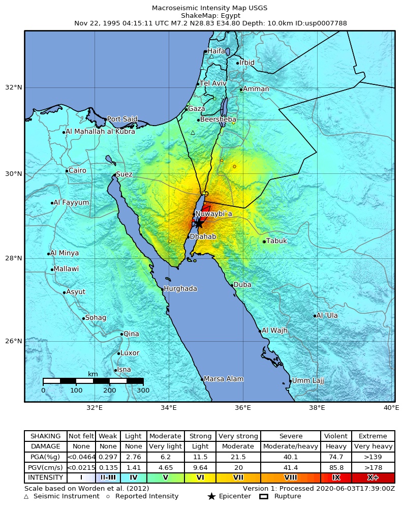
The USGS ShakeMap: shaking estimated from seismic stations and the quake’s size, on the Modified Mercalli intensity scale.
- Strongest estimated
- IX, violent shaking
- Peak ground acceleration
- 121.1% of gravity
- Peak ground velocity
- 4.7 cm/s
- Map
- Automatic
Did you feel it?
No one has reported feeling this quake to the USGS.
Fault motion and ground failure
How the rock slipped, from the moment tensor, and the USGS estimate of landslides and liquefaction.
- Faulting
- Strike-slip
- Moment magnitude
- 7.1 Mww
- Nodal plane 1
- Strike 293°, dip 85°, rake 205°
- Nodal plane 2
- Strike 201°, dip 64°, rake -4°
- Landslide alert
- Orange
- Liquefaction alert
- Green
How well it is located
Reviewed by a seismologist.
- Depth from
- OPERATOR_ASSIGNED
Nearest places
Distance and direction from each place to the epicenter, with its forecast.
Nearby
Within 100 km, magnitude 4.2 and up: 43 in the 60 days after this one and 0 in the 30 days before it.
After
- 4.84 km E of Nuwaybi‘a, Egypt · 11271 days ago · 10 km deep · 26 km away
- 4.47 km ESE of Nuwaybi‘a, Egypt · 11271 days ago · 10 km deep · 23 km away
- 4.935 km SSE of Nuwaybi‘a, Egypt · 11271 days ago · 10 km deep · 8 km away
- 5.150 km E of Dahab, Egypt · 11271 days ago · 10 km deep · 38 km away
- 4.412 km E of Nuwaybi‘a, Egypt · 11271 days ago · 10 km deep · 26 km away
- 5.420 km ENE of Dahab, Egypt · 11270 days ago · 10 km deep · 35 km away
- 4.636 km SSE of Nuwaybi‘a, Egypt · 11270 days ago · 10 km deep · 12 km away
- 5.723 km WSW of Tala Bay, Jordan · 11270 days ago · 10 km deep · 57 km away
- 4.426 km SSE of Tala Bay, Jordan · 11269 days ago · 10 km deep · 52 km away
- 4.514 km SE of Tala Bay, Jordan · 11269 days ago · 10 km deep · 60 km away
- 4.912 km SSE of Nuwaybi‘a, Egypt · 11269 days ago · 10 km deep · 15 km away
- 4.226 km NE of Nuwaybi‘a, Egypt · 11268 days ago · 10 km deep · 41 km away
- 4.818 km ENE of Nuwaybi‘a, Egypt · 11268 days ago · 10 km deep · 33 km away
- 4.225 km S of Tala Bay, Jordan · 11267 days ago · 10 km deep · 45 km away
- 4.528 km ENE of Nuwaybi‘a, Egypt · 11265 days ago · 10 km deep · 38 km away
- 4.425 km NE of Nuwaybi‘a, Egypt · 11264 days ago · 10 km deep · 40 km away
- 4.424 km N of Dahab, Egypt · 11262 days ago · 10 km deep · 30 km away
- 4.420 km N of Nuwaybi‘a, Egypt · 11262 days ago · 10 km deep · 46 km away
- 4.428 km N of Nuwaybi‘a, Egypt · 11261 days ago · 10 km deep · 55 km away
- 4.455 km ESE of Nuwaybi‘a, Egypt · 11261 days ago · 10 km deep · 35 km away
- 4.269 km ESE of Nuwaybi‘a, Egypt · 11260 days ago · 10 km deep · 49 km away
- 4.265 km SE of Nuwaybi‘a, Egypt · 11259 days ago · 10 km deep · 43 km away
- 4.735 km SE of Nuwaybi‘a, Egypt · 11259 days ago · 10 km deep · 14 km away
- 4.319 km NE of Nuwaybi‘a, Egypt · 11259 days ago · 10 km deep · 40 km away
- 4.341 km ESE of Tala Bay, Jordan · 11258 days ago · 10 km deep · 70 km away
- 4.312 km NE of Nuwaybi‘a, Egypt · 11257 days ago · 10 km deep · 34 km away
- 4.737 km SSE of Tala Bay, Jordan · 11257 days ago · 10 km deep · 48 km away
- 4.414 km S of Nuwaybi‘a, Egypt · 11255 days ago · 10 km deep · 18 km away
- 4.385 km SE of Tala Bay, Jordan · 11253 days ago · 10 km deep · 68 km away
- 4.328 km SSE of Nuwaybi‘a, Egypt · 11253 days ago · 10 km deep · 3 km away
- 5.018 km S of Nuwaybi‘a, Egypt · 11252 days ago · 10 km deep · 12 km away
- 4.594 km ESE of Dahab, Egypt · 11252 days ago · 10 km deep · 85 km away
- 4.611 km ESE of Nuwaybi‘a, Egypt · 11252 days ago · 20 km deep · 19 km away
- 4.221 km S of Nuwaybi‘a, Egypt · 11249 days ago · 10 km deep · 16 km away
- 4.215 km NE of Nuwaybi‘a, Egypt · 11249 days ago · 10 km deep · 35 km away
- 4.531 km SSE of Nuwaybi‘a, Egypt · 11248 days ago · 10 km deep · 8 km away
- 4.422 km E of Aqaba, Jordan · 11240 days ago · 9 km deep · 92 km away
- 4.242 km SE of Tala Bay, Jordan · 11238 days ago · 10 km deep · 66 km away
- 5.139 km SE of Tala Bay, Jordan · 11237 days ago · 10 km deep · 55 km away
- 4.946 km SE of Nuwaybi‘a, Egypt · 11229 days ago · 10 km deep · 19 km away
- 4.434 km NE of Dahab, Egypt · 11228 days ago · 10 km deep · 15 km away
- 4.331 km NE of Dahab, Egypt · 11228 days ago · 10 km deep · 17 km away
- 4.327 km S of Nuwaybi‘a, Egypt · 11219 days ago · 10 km deep · 14 km away
Earthquakes todayEgypt earthquakesLive radar here
Sources
From the USGS Earthquake Hazards Program and its partner networks, event usp0007788 (also filed as choy19951122041511, gcmtm112295a, gcmt19951122041511, duputel112295a, atlas19951122041513, iscgem70282). Read Thu, Oct 1, 2026, 8:07 AM UTC.