M6.8 earthquake 23 km E of Toribío, Colombia
A magnitude 6.8 earthquake struck 23 km E of Toribío, Colombia on Mon, Jun 6, 1994, 3:47 PM GMT-5 (20:47 UTC), 12 km (8 mi) below the surface.
Map
Where this earthquake was located, with the others nearby. Select one for its page.
The earthquake
- Magnitude
- 6.8 (Mw, moment), strong
- Magnitude from
- USGS National Earthquake Information Center
- Local time
- UTC
- 1994-06-06 20:47:40 UTC
- Depth
- 12.1 km (7.5 mi), shallow
- Epicenter
- 2.917° N, 76.057° W
- Region
- Colombia
- Strongest shaking
- IX, violent shaking
- Tsunami flag
- No
- Status
- Reviewed by a seismologist
Magnitude estimates
Different scales measure different things and differ by a few tenths. The USGS marks one as preferred, and it is the one this page uses.
| Mag. | Scale | Computed by | Notes |
|---|---|---|---|
| 6.8 | Mw, moment | USGS National Earthquake Information Center | Preferred · Reviewed |
| 6.78 | Mw, moment | ISC-GEM global catalog | Final · ±0.1 |
| 6.8 | Mwc, centroid moment | Global CMT project | Preliminary |
| 7.22 | Me, energy | Choy, USGS energy magnitude | Reviewed |
| 6.8 | Mww, W-phase moment | Duputel, W-phase inversion | Preliminary |
Deaths and damage
From NOAA NCEI’s Significant Earthquake Database (record 5387), matched to this event by time and place.
- Deaths
- 650
- Damage
- $2.4 million
- Houses destroyed
- 200
Where the literature gives no number, NCEI records a description on a scale of 1 to 4, printed here in its words. Damage is in millions of US dollars of the year of the event, not adjusted for inflation.
From Wikipedia
The 1994 Páez River earthquake occurred on June 6 with a moment magnitude of 6.8 at a depth of 12 km (7.5 mi). The event, which is also known as the Páez River disaster, included subsequent landslides and mudslides that destroyed much of the Páez municipality, located on the foothills of the Central Ranges of the Andes in Cauca in south-western Colombia.[1] It was estimated that 1,100 people, mostly from the Páez, were killed in some 15 settlements on the Páez River basin, Cauca and Huila departments of which the eponymous municipality of Páez suffered 50% of the death toll.[2][3] In response to the disaster, the government created the Nasa Kiwe Corporation to bring relief to the area, and begin the reconstruction of the affected areas.
Text from Wikipedia, “1994 Páez River earthquake”, licensed CC BY-SA 4.0. Quoted as written; the full article has the rest.
The article is about the earthquake NOAA’s record describes, matched to this one by date, place and magnitude.
What happened
The USGS’s account of the effects of this earthquake.
At least 295 people killed, 500 missing, 13,000 homeless and severe damage caused to houses, highways and bridges by the earthquake and ensuing landslides in Cauca, Huila, Tolima and Valle Departments. At least 200 homes were destroyed, including 25 at Toribio and 15 at Piendamo. Moderate structural damage occurred at Bogota and Cali. An avalanche from the Huila Volcano blocked the Paez River causing severe flooding at Belalcazar and Neiva. Felt in much of west-central Colombia from Tunja to Pasto. Depth from broadband displacement seismograms. FAULT PLANE SOLUTION: P-Waves NP1:Strike=30 Dip=83 Slip=165 NP2:Strike=122 Dip=75 Slip=7 Principal Axes: (T) Plg=16 Azm=345 (P) Plg=5 Azm=77 Comment: The focal mechanism is moderately well controlled and corresponds to strike-slip faulting with a small reverse component. The preferred fault plane is not determined. RADIATED ENERGY No. of sta: 21 Focal mech. F Energy 1.7+0.3*10**15 Nm MOMENT TENSOR SOLUTION Dep 20 No. of sta: 36 Moment Tensor; Scale 10**19 Nm Mrr=-0.02 Mtt=1.22 Mff=-1.19 Mrt=0.10 Mrf=0.25 Mtf=0.51 Principal axes: (T) Val=1.34 Plg=6 Azm=348 (N) Val=0.00 Plg=78 Azm=227 (P) Val=-1.34 Plg=10 Azm=79 Best Double Couple:Mo=1.3*10**19 NP1:Strike=123 Dip=79 Slip=-3 NP2:Strike=214 Dip=87 Slip=-169 CENTROID, MOMENT TENSOR (HRV) Data Used: GDSN L.P.B.: 65S,162C M.W.: 58S,125C Centroid Location: Origin Time 20:47:47.4 0.1 Lat 2.93N 0.01 Lon 75.94W 0.01 Dep 15.0 BDY Half-duration 6.2 Moment Tensor; Scale 10**19 Nm Mrr=-0.05 0.01 Mtt=1.46 0.01 Mff=-1.41 0.01 Mrt=-0.61 0.03 Mrf=-0.10 0.03 Mtf=1.00 0.01 Principal Axes: (T) Val=1.96 Plg=17 Azm=163 (N) Val=-0.24 Plg=73 Azm=332 (P) Val=-1.72 Plg=3 Azm=72 Best Double Couple:Mo=1.8*10**19 NP1:Strike=206 Dip=76 Slip=170 NP2:Strike=299 Dip=80 Slip=14
From the USGS event page for usp0006dv8. U.S. Geological Survey text and figures are in the public domain.
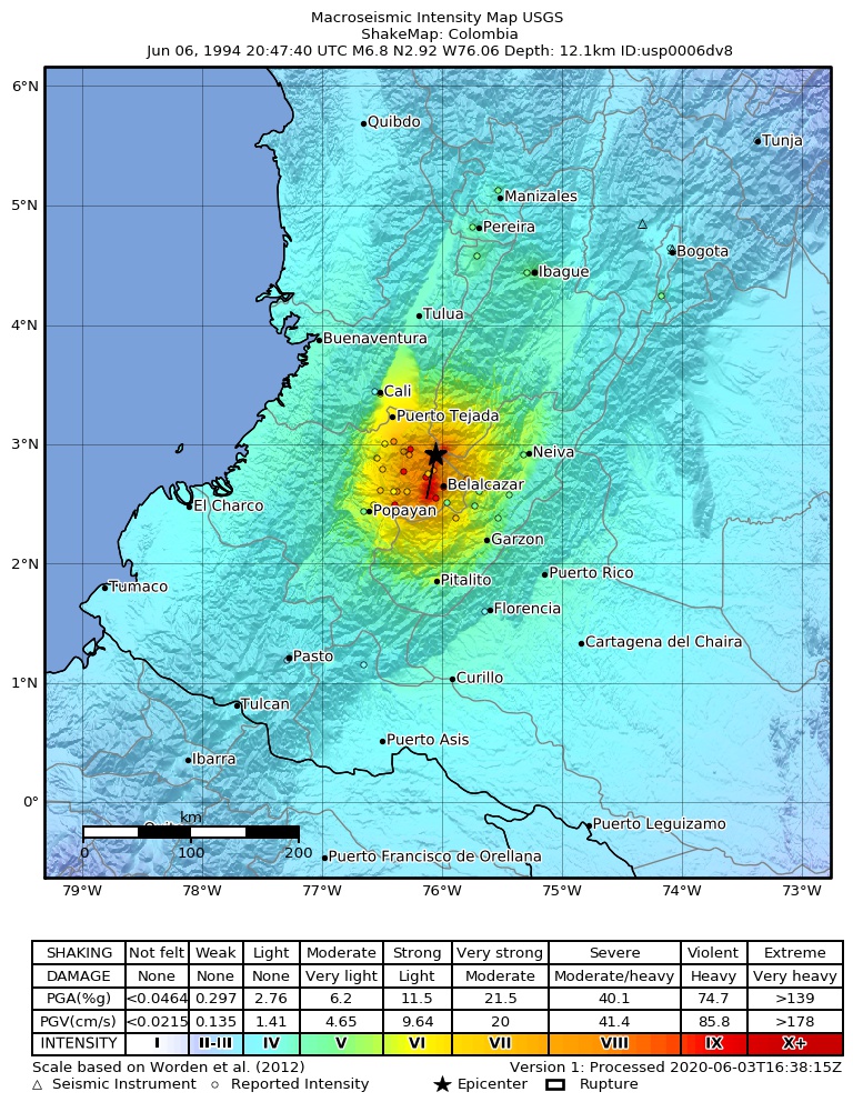
Shaking
The USGS ShakeMap: shaking estimated from seismic stations and the quake’s size, on the Modified Mercalli intensity scale.
- Strongest estimated
- IX, violent shaking
- Peak ground acceleration
- 129.0% of gravity
- Peak ground velocity
- 5.0 cm/s
- Map
- Automatic
Did you feel it?
No one has reported feeling this quake to the USGS.
Fault motion and ground failure
How the rock slipped, from the moment tensor, and the USGS estimate of landslides and liquefaction.
- Faulting
- Strike-slip
- Moment magnitude
- 6.8 Mww
- Nodal plane 1
- Strike 118°, dip 79°, rake 3°
- Nodal plane 2
- Strike 27°, dip 86°, rake 169°
- Landslide alert
- Red
- Liquefaction alert
- Red
How well it is located
Reviewed by a seismologist.
- Depth from
- OPERATOR_ASSIGNED
Nearest places
Distance and direction from each place to the epicenter, with its forecast.
Nearby
Within 100 km, magnitude 3.8 and up: 4 in the 60 days after this one and 0 in the 30 days before it.
After
- 3.94 km ESE of Belalcázar, Colombia · 11804 days ago · 33 km deep · 35 km away
- 4.49 km NE of Belalcázar, Colombia · 11804 days ago · 43 km deep · 27 km away
- 3.815 km NNW of Belalcázar, Colombia · 11802 days ago · 55 km deep · 17 km away
- 4.417 km SE of Toribío, Colombia · 11747 days ago · 10 km deep · 15 km away
Earthquakes todayColombia earthquakesLive radar here
Sources
From the USGS Earthquake Hazards Program and its partner networks, event usp0006dv8 (also filed as choy19940606204740, gcmtc060694j, gcmt19940606204739, duputel060694j, atlas19940606204742, iscgem167996). Read Fri, Oct 2, 2026, 2:09 AM UTC.