M5.9 earthquake 33 km S of Jonquière, Canada
A magnitude 5.9 earthquake struck 33 km S of Jonquière, Canada on Fri, Nov 25, 1988, 6:46 PM EST (23:46 UTC), 29 km (18 mi) below the surface.
Map
Where this earthquake was located, with the others nearby. Select one for its page.
The earthquake
- Magnitude
- 5.9 (Mw, moment), moderate
- Magnitude from
- USGS National Earthquake Information Center
- Local time
- UTC
- 1988-11-25 23:46:04 UTC
- Depth
- 28.9 km (18.0 mi), shallow
- Epicenter
- 48.117° N, 71.183° W
- Region
- Canada
- Strongest shaking
- VII, very strong shaking
- Tsunami flag
- No
- Status
- Reviewed by a seismologist
Magnitude estimates
Different scales measure different things and differ by a few tenths. The USGS marks one as preferred, and it is the one this page uses.
| Mag. | Scale | Computed by | Notes |
|---|---|---|---|
| 5.9 | Mw, moment | USGS National Earthquake Information Center | Preferred · Reviewed |
| 5.83 | Mw, moment | ISC-GEM global catalog | Final · ±0.1 |
| 5.8 | Mwc, centroid moment | Global CMT project | Preliminary |
| 5.89 | Me, energy | Choy, USGS energy magnitude | Reviewed |
Deaths and damage
From NOAA NCEI’s Significant Earthquake Database (record 5183), matched to this event by time and place.
- Deaths
- 2
- Injuries
- 50
- Damage
- Moderate (about $1 to $5 million)
Where the literature gives no number, NCEI records a description on a scale of 1 to 4, printed here in its words. Damage is in millions of US dollars of the year of the event, not adjusted for inflation.
From Wikipedia
The 1988 Saguenay earthquake struck Quebec, Canada with a moment magnitude of 5.9 on November 25. It is one of the largest recorded earthquakes in eastern Canada and eastern North America during the 20th century. The earthquake was felt by millions, and damaged some buildings. It could be felt as far as Toronto, Halifax, and Boston.
The earthquake was triggered by faults associated with the Saguenay Graben.
Aftershocks were felt as far south as Pennsylvania, USA, and as far west as Michigan.
Text from Wikipedia, “1988 Saguenay earthquake”, licensed CC BY-SA 4.0. Quoted as written; the full article has the rest.
The article is about the earthquake NOAA’s record describes, matched to this one by date, place and magnitude.
What happened
The USGS’s account of the effects of this earthquake.
Damage in the Chicoutimi-La Baie area and in the Quebec City area. Maximum intensity VII. Landslides reported in the La Tuque area. Felt in Canada from southern Ontario to Nova Scotia and western Labrador. Felt (V) in parts of Maine, Vermont, New Hampshire and New York. Felt in the New England States and in parts of Indiana, Michigan, New Jersey, New York, Ohio, Pennsylvania, Wisconsin and as far south as Washington, D.C. Depth 19.8 kilometers from broadband displacement seismograms. FAULT PLANE SOLUTION: P-Waves NP1:Strike=340 Dip=63 Slip=90 NP2:Strike=160 Dip=27 Slip=90 Principal Axes: (T) Plg=72 Azm=250 (P) Plg=18 Azm=70 Comment: The focal mechanism is poorly controlled and corresponds to reverse faulting. The preferred fault plane is not determined. RADIATED ENERGY No. of sta: 5 Focal mech. C Energy 1.9+0.8*10**13 Nm CENTROID, MOMENT TENSOR (HRV) Data Used: GDSN L.P.B.: 10S, 25C Centroid Location: Origin Time 23:46: 3.1 0.7 Lat 48.01N 0.07 Lon 71.16W 0.05 Dep 27.5 3.6 Half-duration 3.4 Moment Tensor; Scale 10**17 Nm Mrr=5.16 0.20 Mtt=0.03 0.25 Mff=-5.19 0.24 Mrt=-4.56 0.70 Mrf=1.07 0.50 Mtf=1.17 0.22 Principal Axes: (T) Val=7.83 Plg=60 Azm=183 (N) Val=-1.90 Plg=26 Azm=332 (P) Val=-5.93 Plg=14 Azm=68 Best Double Couple:Mo=6.9*10**17 NP1:Strike=189 Dip=39 Slip=135 NP2:Strike=317 Dip=64 Slip=60
From the USGS event page for usp0003p6p. U.S. Geological Survey text and figures are in the public domain.
Shaking
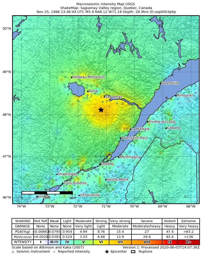
The USGS ShakeMap: shaking estimated from seismic stations and the quake’s size, on the Modified Mercalli intensity scale.
- Strongest estimated
- VII, very strong shaking
- Peak ground acceleration
- 26.8% of gravity
- Peak ground velocity
- 2.9 cm/s
- Map
- Automatic
Did you feel it?
No one has reported feeling this quake to the USGS.
Fault motion and ground failure
How the rock slipped, from the moment tensor, and the USGS estimate of landslides and liquefaction.
- Landslide alert
- Yellow
- Liquefaction alert
- Green
Nearest places
Distance and direction from each place to the epicenter, with its forecast.
Nearby
Within 100 km, magnitude 2.9 and up: 3 in the 60 days after this one and 1 in the 30 days before it.
After
- 4.130 km S of Jonquière, Canada · 13825 days ago · 26 km deep · 10 km away
- 2.930 km S of Jonquière, Canada · 13825 days ago · 25 km deep · 8 km away
- 3.939 km SSE of Saguenay, Canada · 13770 days ago · 30 km deep · 17 km away
Before
Earthquakes todayCanada earthquakesLive radar here
Sources
From the USGS Earthquake Hazards Program and its partner networks, event usp0003p6p (also filed as choy19881125234604, gcmtb112588c, gcmt19881125234604, atlas19881125234605, iscgem421305). Read Sat, Oct 3, 2026, 4:10 AM UTC.