M6.4 earthquake 37 km WNW of Atka, Alaska
A magnitude 6.4 earthquake struck 37 km WNW of Atka, Alaska on Wed, May 14, 1986, 9:38 PM HADT (06:38 UTC), 33 km (21 mi) below the surface.
A larger quake followed: M6.5 25 km NW of Atka, Alaska. This one was a foreshock.
Map
Where this earthquake was located, with the others nearby. Select one for its page.
The earthquake
- Magnitude
- 6.4 (mw), strong
- Local time
- UTC
- 1986-05-15 06:38:37 UTC
- Depth
- 33.0 km (20.5 mi), shallow
- Epicenter
- 52.294° N, 174.726° W
- Region
- Alaska
- Strongest shaking
- VI, strong shaking
- Tsunami flag
- No
- Status
- Reviewed by a seismologist
Shaking
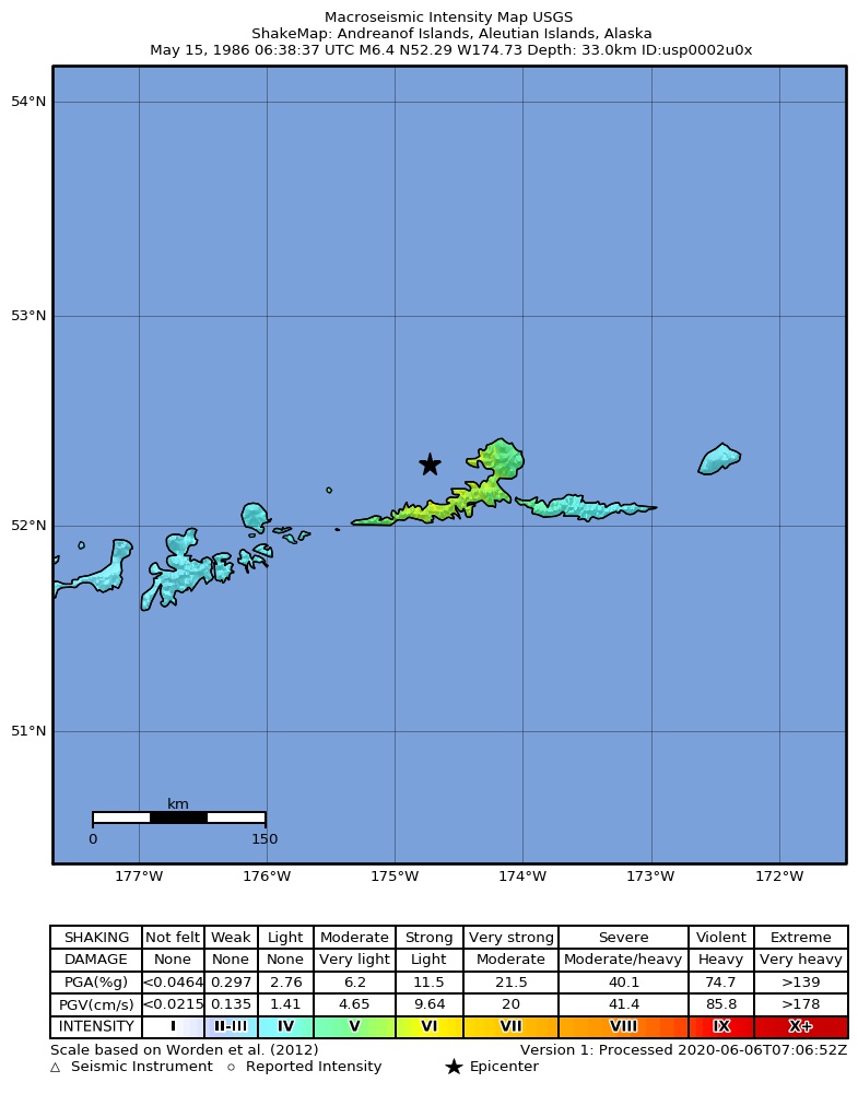
The USGS ShakeMap: shaking estimated from seismic stations and the quake’s size, on the Modified Mercalli intensity scale.
- Strongest estimated
- VI, strong shaking
- Peak ground acceleration
- 15.3% of gravity
- Peak ground velocity
- 2.5 cm/s
- Map
- Automatic
Did you feel it?
No one has reported feeling this quake to the USGS.
How well it is located
Reviewed by a seismologist.
- Depth from
- OPERATOR_ASSIGNED
Nearby
Within 100 km, magnitude 3.4 and up: 51 in the 60 days after this one and 69 in the 30 days before it.
After
- 4.726 km W of Atka, Alaska · 14748 days ago · 33 km deep · 16 km away
- 4.436 km WSW of Atka, Alaska · 14748 days ago · 33 km deep · 28 km away
- 4.338 km SSW of Atka, Alaska · 14748 days ago · 33 km deep · 52 km away
- 3.845 km WNW of Atka, Alaska · 14748 days ago · 33 km deep · 8 km away
- 4.833 km W of Atka, Alaska · 14748 days ago · 33 km deep · 11 km away
- 4.042 km WSW of Atka, Alaska · 14748 days ago · 33 km deep · 27 km away
- 4.219 km WSW of Atka, Alaska · 14748 days ago · 33 km deep · 23 km away
- 4.122 km WNW of Atka, Alaska · 14748 days ago · 33 km deep · 15 km away
- 5.325 km WNW of Atka, Alaska · 14748 days ago · 33 km deep · 14 km away
- 5.622 km W of Atka, Alaska · 14748 days ago · 33 km deep · 16 km away
- 3.822 km SW of Atka, Alaska · 14748 days ago · 33 km deep · 30 km away
- 4.098 km SW of Atka, Alaska · 14747 days ago · 33 km deep · 90 km away
- 5.082 km WSW of Atka, Alaska · 14747 days ago · 33 km deep · 62 km away
- 4.6101 km SW of Atka, Alaska · 14747 days ago · 33 km deep · 93 km away
- 4.889 km SW of Atka, Alaska · 14747 days ago · 33 km deep · 76 km away
- 6.525 km NW of Atka, Alaska · 14746 days ago · 26 km deep · 16 km away
- 4.922 km W of Atka, Alaska · 14746 days ago · 33 km deep · 16 km away
- 5.192 km SSW of Atka, Alaska · 14745 days ago · 33 km deep · 97 km away
- 4.984 km SW of Atka, Alaska · 14745 days ago · 33 km deep · 67 km away
- 4.774 km SSW of Atka, Alaska · 14745 days ago · 33 km deep · 75 km away
- 4.657 km W of Atka, Alaska · 14745 days ago · 33 km deep · 22 km away
- 5.451 km W of Atka, Alaska · 14744 days ago · 33 km deep · 15 km away
- 5.048 km W of Atka, Alaska · 14744 days ago · 33 km deep · 12 km away
- 4.021 km SW of Atka, Alaska · 14744 days ago · 33 km deep · 32 km away
- 3.851 km W of Atka, Alaska · 14744 days ago · 33 km deep · 24 km away
- 4.389 km SW of Atka, Alaska · 14743 days ago · 33 km deep · 81 km away
- 4.885 km E of Adak, Alaska · 14742 days ago · 33 km deep · 69 km away
- 4.655 km SW of Atka, Alaska · 14739 days ago · 33 km deep · 55 km away
- 5.091 km SW of Atka, Alaska · 14738 days ago · 33 km deep · 77 km away
- 4.896 km SSW of Atka, Alaska · 14738 days ago · 33 km deep · 98 km away
- 4.752 km SSW of Atka, Alaska · 14737 days ago · 33 km deep · 58 km away
- 4.962 km S of Atka, Alaska · 14736 days ago · 33 km deep · 79 km away
- 4.992 km ESE of Adak, Alaska · 14734 days ago · 33 km deep · 82 km away
- 4.247 km ENE of Adak, Alaska · 14731 days ago · 33 km deep · 92 km away
- 4.575 km SSW of Atka, Alaska · 14730 days ago · 33 km deep · 81 km away
- 5.493 km SSW of Atka, Alaska · 14729 days ago · 33 km deep · 98 km away
- 5.038 km SW of Atka, Alaska · 14728 days ago · 33 km deep · 40 km away
- 4.988 km SSW of Atka, Alaska · 14728 days ago · 33 km deep · 94 km away
- 4.765 km S of Atka, Alaska · 14727 days ago · 33 km deep · 84 km away
- 5.377 km S of Atka, Alaska · 14727 days ago · 33 km deep · 94 km away
- 4.461 km SW of Atka, Alaska · 14726 days ago · 33 km deep · 60 km away
- 4.885 km SSW of Atka, Alaska · 14725 days ago · 33 km deep · 83 km away
- 4.871 km SW of Atka, Alaska · 14724 days ago · 33 km deep · 68 km away
- 4.397 km SSW of Atka, Alaska · 14717 days ago · 33 km deep · 100 km away
- 4.493 km ESE of Adak, Alaska · 14716 days ago · 33 km deep · 90 km away
- 4.5104 km SW of Atka, Alaska · 14715 days ago · 33 km deep · 96 km away
- 4.887 km SW of Atka, Alaska · 14710 days ago · 33 km deep · 73 km away
- 4.665 km WSW of Atka, Alaska · 14710 days ago · 33 km deep · 37 km away
- 4.383 km SW of Atka, Alaska · 14709 days ago · 33 km deep · 70 km away
- 5.446 km WNW of Atka, Alaska · 14703 days ago · 33 km deep · 9 km away
- 4.743 km W of Atka, Alaska · 14703 days ago · 33 km deep · 9 km away
Before
- 4.770 km S of Atka, Alaska · 14749 days ago · 33 km deep · 87 km away
- 4.785 km SSW of Atka, Alaska · 14750 days ago · 33 km deep · 89 km away
- 4.380 km SW of Atka, Alaska · 14750 days ago · 33 km deep · 67 km away
- 4.940 km WSW of Atka, Alaska · 14751 days ago · 33 km deep · 33 km away
- 5.5Andreanof Islands, Aleutian Islands, Alaska · 14751 days ago · 33 km deep · 97 km away
- 5.781 km SSW of Atka, Alaska · 14752 days ago · 33 km deep · 85 km away
- 4.872 km S of Atka, Alaska · 14752 days ago · 33 km deep · 90 km away
- 4.481 km SW of Atka, Alaska · 14752 days ago · 33 km deep · 70 km away
- 4.178 km SSW of Atka, Alaska · 14753 days ago · 33 km deep · 78 km away
- 4.777 km SSW of Atka, Alaska · 14753 days ago · 33 km deep · 81 km away
- 4.056 km W of Atka, Alaska · 14753 days ago · 33 km deep · 23 km away
- 4.840 km SSE of Atka, Alaska · 14753 days ago · 33 km deep · 68 km away
- 5.168 km WSW of Atka, Alaska · 14753 days ago · 33 km deep · 50 km away
- 4.882 km S of Atka, Alaska · 14753 days ago · 33 km deep · 96 km away
- 5.981 km S of Atka, Alaska · 14754 days ago · 33 km deep · 98 km away
- 4.236 km WSW of Atka, Alaska · 14754 days ago · 33 km deep · 20 km away
- 4.726 km S of Atka, Alaska · 14754 days ago · 33 km deep · 55 km away
- 3.976 km SW of Atka, Alaska · 14754 days ago · 33 km deep · 63 km away
- 4.876 km ESE of Adak, Alaska · 14754 days ago · 33 km deep · 100 km away
- 5.141 km SSE of Atka, Alaska · 14755 days ago · 33 km deep · 69 km away
Earthquakes todayAlaska earthquakesLive radar here
Sources
From the USGS Earthquake Hazards Program and its partner networks, event usp0002u0x (also filed as gcmtc051586a, ushis3949, gcmt19860515063837, iscgem495695). Read Wed, Sep 30, 2026, 11:02 AM UTC.