M6.5 earthquake 57 km S of Adak, Alaska
A magnitude 6.5 earthquake struck 57 km S of Adak, Alaska on Tue, Jun 17, 1986, 11:05 PM HADT (08:05 UTC), 27 km (17 mi) below the surface.
Map
Where this earthquake was located, with the others nearby. Select one for its page.
The earthquake
- Magnitude
- 6.5 (Mw, moment), strong
- Magnitude from
- USGS National Earthquake Information Center
- Local time
- UTC
- 1986-06-18 08:05:15 UTC
- Depth
- 27.0 km (16.8 mi), shallow
- Epicenter
- 51.356° N, 176.653° W
- Region
- Alaska
- Strongest shaking
- V, moderate shaking
- Tsunami flag
- No
- Status
- Reviewed by a seismologist
Magnitude estimates
Different scales measure different things and differ by a few tenths. The USGS marks one as preferred, and it is the one this page uses.
| Mag. | Scale | Computed by | Notes |
|---|---|---|---|
| 6.5 | Mw, moment | USGS National Earthquake Information Center | Preferred · Reviewed |
| 6.45 | Mw, moment | ISC-GEM global catalog | Final · ±0.1 |
| 6.47 | Mw, moment | USGS historic United States catalog | Final |
| 6.4 | Mwc, centroid moment | Global CMT project | Preliminary |
What happened
The USGS’s account of the effects of this earthquake.
Felt (IV) on Adak and (III) on Atka. Depth 23.2 km. from broadband displacement seismograms. FAULT PLANE SOLUTION: P-Waves NP1:Strike=57 Dip=65 Slip=90 NP2:Strike=237 Dip=25 Slip=90 Principal Axes: (T) Plg=70 Azm=327 (P) Plg=20 Azm=147 Comment: The focal mechanism is poorly controlled and corresponds to reverse faulting. The preferred fault plane is NP2. CENTROID, MOMENT TENSOR (HRV) Data Used: GDSN L.P.B.: 20S, 48C M.W.: 8S, 19C Centroid Location: Origin Time 08:05:19.1 0.2 Lat 51.71N 0.01 Lon 176.54W 0.03 Dep 44.5 0.9 Half-duration 6.3 Moment Tensor; Scale 10**25 D-CM Mrr=4.56 0.07 Mtt=-3.92 0.06 Mff=-0.64 0.05 Mrt=2.60 0.12 Mrf=2.54 0.12 Mtf=-1.53 0.05 Principal Axes: (T) Val=5.96 Plg=68 Azm=302 (N) Val=-0.30 Plg=11 Azm=60 (P) Val=-5.66 Plg=19 Azm=154 Best Double Couple:Mo=5.8*10**25 NP1:Strike=261 Dip=28 Slip=113 NP2:Strike=55 Dip=64 Slip=78
Maximum observed Modified Mercalli Intensity (MMI) IV
From the USGS event page for usp0002v5r. U.S. Geological Survey text and figures are in the public domain.
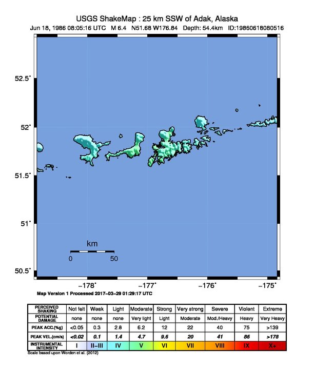
Shaking
The USGS ShakeMap: shaking estimated from seismic stations and the quake’s size, on the Modified Mercalli intensity scale.
- Strongest estimated
- V, moderate shaking
- Map
- Automatic
Did you feel it?
No one has reported feeling this quake to the USGS.
Nearby
Within 100 km, magnitude 3.5 and up: 40 in the 60 days after this one and 25 in the 30 days before it.
After
- 4.589 km SSE of Adak, Alaska · 14715 days ago · 33 km deep · 49 km away
- 4.883 km SSE of Adak, Alaska · 14715 days ago · 33 km deep · 40 km away
- 4.271 km SE of Adak, Alaska · 14715 days ago · 33 km deep · 49 km away
- 4.536 km SW of Adak, Alaska · 14715 days ago · 33 km deep · 35 km away
- 4.576 km SE of Adak, Alaska · 14712 days ago · 33 km deep · 54 km away
- 4.263 km SW of Adak, Alaska · 14711 days ago · 33 km deep · 44 km away
- 4.6101 km SE of Adak, Alaska · 14711 days ago · 33 km deep · 73 km away
- 4.359 km SW of Adak, Alaska · 14710 days ago · 33 km deep · 39 km away
- 4.853 km S of Adak, Alaska · 14703 days ago · 33 km deep · 4 km away
- 4.558 km S of Adak, Alaska · 14703 days ago · 33 km deep · 3 km away
- 4.455 km SE of Adak, Alaska · 14703 days ago · 33 km deep · 55 km away
- 5.475 km SSE of Adak, Alaska · 14703 days ago · 33 km deep · 35 km away
- 4.236 km S of Adak, Alaska · 14703 days ago · 33 km deep · 21 km away
- 4.093 km SSE of Adak, Alaska · 14703 days ago · 33 km deep · 47 km away
- 4.291 km SSE of Adak, Alaska · 14703 days ago · 33 km deep · 45 km away
- 4.484 km SSE of Adak, Alaska · 14703 days ago · 33 km deep · 40 km away
- 4.761 km SW of Adak, Alaska · 14702 days ago · 33 km deep · 34 km away
- 5.063 km SE of Adak, Alaska · 14700 days ago · 33 km deep · 52 km away
- 4.975 km ESE of Adak, Alaska · 14699 days ago · 33 km deep · 67 km away
- 4.569 km SE of Adak, Alaska · 14696 days ago · 33 km deep · 44 km away
- 5.527 km E of Adak, Alaska · 14694 days ago · 50 km deep · 68 km away
- 5.026 km SW of Adak, Alaska · 14694 days ago · 57 km deep · 39 km away
- 4.879 km SE of Adak, Alaska · 14681 days ago · 33 km deep · 66 km away
- 5.257 km SSE of Adak, Alaska · 14680 days ago · 33 km deep · 33 km away
- 4.983 km SSE of Adak, Alaska · 14680 days ago · 33 km deep · 39 km away
- 4.952 km S of Adak, Alaska · 14679 days ago · 33 km deep · 6 km away
- 5.876 km SSE of Adak, Alaska · 14678 days ago · 33 km deep · 36 km away
- 5.683 km SSE of Adak, Alaska · 14678 days ago · 33 km deep · 45 km away
- 4.669 km ESE of Adak, Alaska · 14678 days ago · 33 km deep · 82 km away
- 4.793 km SSE of Adak, Alaska · 14677 days ago · 33 km deep · 55 km away
- 4.497 km SSE of Adak, Alaska · 14676 days ago · 33 km deep · 49 km away
- 4.844 km E of Adak, Alaska · 14675 days ago · 33 km deep · 73 km away
- 4.883 km SSE of Adak, Alaska · 14671 days ago · 33 km deep · 38 km away
- 4.986 km SSE of Adak, Alaska · 14671 days ago · 33 km deep · 42 km away
- 4.354 km SSE of Adak, Alaska · 14671 days ago · 33 km deep · 28 km away
- 5.076 km SE of Adak, Alaska · 14670 days ago · 33 km deep · 46 km away
- 5.979 km S of Adak, Alaska · 14669 days ago · 33 km deep · 24 km away
- 4.784 km S of Adak, Alaska · 14669 days ago · 33 km deep · 27 km away
- 4.987 km S of Adak, Alaska · 14669 days ago · 33 km deep · 30 km away
- 4.780 km S of Adak, Alaska · 14669 days ago · 33 km deep · 23 km away
Before
- 4.493 km ESE of Adak, Alaska · 14717 days ago · 33 km deep · 93 km away
- 4.682 km SE of Adak, Alaska · 14723 days ago · 33 km deep · 61 km away
- 4.577 km SE of Adak, Alaska · 14723 days ago · 33 km deep · 47 km away
- 4.379 km SSE of Adak, Alaska · 14723 days ago · 33 km deep · 46 km away
- 4.7107 km SSW of Adak, Alaska · 14725 days ago · 33 km deep · 66 km away
- 5.1106 km SE of Adak, Alaska · 14728 days ago · 33 km deep · 91 km away
- 4.181 km SSE of Adak, Alaska · 14731 days ago · 33 km deep · 35 km away
- 4.247 km ENE of Adak, Alaska · 14732 days ago · 33 km deep · 92 km away
- 4.386 km SE of Adak, Alaska · 14733 days ago · 33 km deep · 64 km away
- 4.8113 km SE of Adak, Alaska · 14734 days ago · 33 km deep · 94 km away
- 4.992 km ESE of Adak, Alaska · 14735 days ago · 33 km deep · 97 km away
- 4.881 km SSE of Adak, Alaska · 14736 days ago · 33 km deep · 42 km away
- 4.281 km SE of Adak, Alaska · 14737 days ago · 33 km deep · 63 km away
- 4.763 km SSE of Adak, Alaska · 14739 days ago · 33 km deep · 36 km away
- 4.892 km SSE of Adak, Alaska · 14739 days ago · 33 km deep · 50 km away
- 4.689 km SSE of Adak, Alaska · 14740 days ago · 33 km deep · 41 km away
- 4.989 km SSE of Adak, Alaska · 14741 days ago · 33 km deep · 44 km away
- 4.5104 km SE of Adak, Alaska · 14742 days ago · 33 km deep · 76 km away
- 4.573 km ESE of Adak, Alaska · 14742 days ago · 33 km deep · 72 km away
- 4.898 km SE of Adak, Alaska · 14743 days ago · 33 km deep · 80 km away
Earthquakes todayAlaska earthquakesLive radar here
Sources
From the USGS Earthquake Hazards Program and its partner networks, event usp0002v5r (also filed as gcmtc061886a, ushis3955, gcmt19860618080516, atlas19860618080516, iscgem493430). Read Thu, Oct 1, 2026, 10:30 AM UTC.