M6.3 earthquake 17 km N of Dham?r, Yemen
A magnitude 6.3 earthquake struck 17 km N of Dham?r, Yemen on Mon, Dec 13, 1982, 12:12 PM GMT+3 (09:12 UTC), 5 km (3 mi) below the surface.
Map
Where this earthquake was located, with the others nearby. Select one for its page.
The earthquake
- Magnitude
- 6.3 (Mw, moment), strong
- Magnitude from
- USGS National Earthquake Information Center
- Local time
- UTC
- 1982-12-13 09:12:48 UTC
- Depth
- 5.0 km (3.1 mi), shallow
- Epicenter
- 14.701° N, 44.379° E
- Region
- Yemen
- Strongest shaking
- VIII, severe shaking
- Tsunami flag
- No
- Status
- Reviewed by a seismologist
Magnitude estimates
Different scales measure different things and differ by a few tenths. The USGS marks one as preferred, and it is the one this page uses.
| Mag. | Scale | Computed by | Notes |
|---|---|---|---|
| 6.3 | Mw, moment | USGS National Earthquake Information Center | Preferred · Reviewed |
| 6.2 | Mw, moment | ISC-GEM global catalog | Final · ±0.1 |
| 6.2 | Mwc, centroid moment | Global CMT project | Preliminary |
| 6.19 | Me, energy | Choy, USGS energy magnitude | Reviewed |
Deaths and damage
From NOAA NCEI’s Significant Earthquake Database (record 4954), matched to this event by time and place.
- Deaths
- 2,800
- Injuries
- 1,500
- Damage
- $2 billion
- Houses destroyed
- Very many (over 1,000)
Where the literature gives no number, NCEI records a description on a scale of 1 to 4, printed here in its words. Damage is in millions of US dollars of the year of the event, not adjusted for inflation.
From Wikipedia
The 1982 North Yemen earthquake hit near the city of Dhamar, North Yemen (now part of Yemen) on December 13. Measuring 6.2 on the moment magnitude scale, with a maximum perceived intensity of VIII (Severe) on the Mercalli intensity scale, as many as 2,800 people were killed and another 1,500 injured. The shock occurred within several hundred kilometers of a plate boundary in a geologically complex region that includes active volcanoes and seafloor spreading ridges. Yemen has a history of destructive earthquakes, though this was the first instrumentally recorded event to be detected on global seismograph networks.
Text from Wikipedia, “1982 North Yemen earthquake”, licensed CC BY-SA 4.0. Quoted as written; the full article has the rest.
The article is about the earthquake NOAA’s record describes, matched to this one by date, place and magnitude.
What happened
The USGS’s account of the effects of this earthquake.
Unconfirmed reports of 2,800 people killed, 1,500 injured, 700,000 homeless and about 300 villages destroyed or badly damaged in Yemen. Maximum intensity VIII in the Dawran-Risabah area. Felt throughout Yemen and in the Najran area, Saudi Arabia. Landslides occurred in the epicentral area, as well as extensional ground cracks trending north-northwest in zones up to 15 km. in length. This is the first instrumentally located hypocenter in the Dhamar region. [FS]. FAULT PLANE SOLUTION: P-WAVES NP1:STRIKE=340;DIP=75;SLIP=270 NP2:STRIKE=160;DIP=15;SLIP=270 PRINCIPAL AXES: (T) PLG=30; AZM=70 (P) PLG=60; AZM=250 COMMENT: Poorly controlled normal fault type mechanism. NP1 designated as the fault plane. MOMENT TENSOR SOLUTION NO OF STA 11 SCALE 10**25 D-CM PRINCIPAL AXES: (T) VAL=3.40; PLG=14; AZM=77 (N) VAL=-0.36; PLG=25; AZM=340 (P) VAL=-3.04; PLG=61; AZM=193 BEST DOUBLE COUPLE:Mo=3.2*10**25 NP1:STRIKE=197;DIP=38;SLIP=-47 NP2:STRIKE=326;DIP=63;SLIP=-118 CENTROID, MOMENT TENSOR SOLUTION HARVARD EVENT-FILE NAME B121382B DATA USED: GDSN L.P. BODY WAVES: 21S, 55C, T=45 CENTROID LOCATION: ORIGIN TIME 9:13: 1.2 0.2 LAT 14.99N 0.02;LON 44.60E 0.02 DEP 10.1 FIX;HALF-DURATION 4.5 MOMENT TENSOR; SCALE 10**25 D-CM MRR=-2.28 0.04; MTT=1.03 0.04 MFF=1.26 0.05; MRT=0.39 0.16 MRF=-0.61 0.12; MTF=-1.39 0.05 PRINCIPAL AXES: 1.(T) VAL=2.64;PLG=8;AZM=48 2.(N) -0.25; 3; 138 3.(P) -2.39; 81; 249 BEST DOUBLE COUPLE:M0=2.5*10**25 NP1:STRIKE=134;DIP=37;SLIP=-95 NP2:Strike=320;Dip=53;Slip=-86
From the USGS event page for usp0001reb. U.S. Geological Survey text and figures are in the public domain.
Shaking
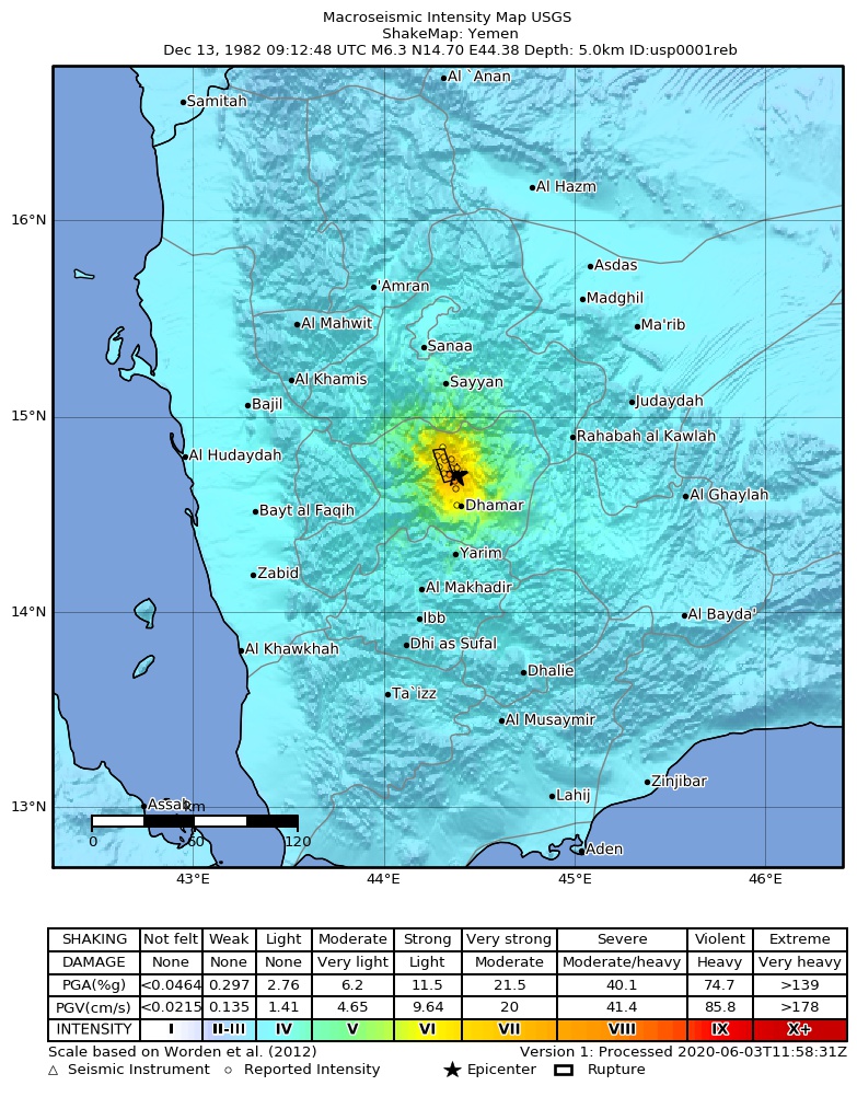
The USGS ShakeMap: shaking estimated from seismic stations and the quake’s size, on the Modified Mercalli intensity scale.
- Strongest estimated
- VIII, severe shaking
- Peak ground acceleration
- 53.8% of gravity
- Peak ground velocity
- 3.7 cm/s
- Map
- Automatic
Did you feel it?
No one has reported feeling this quake to the USGS.
Nearest places
Distance and direction from each place to the epicenter, with its forecast.
Nearby
Within 100 km, magnitude 3.3 and up: 6 in the 60 days after this one and 0 in the 30 days before it.
After
- 4.016 km N of Dham?r, Yemen · 16001 days ago · 5 km deep · 3 km away
- 4.640 km WNW of Dham?r, Yemen · 16001 days ago · 5 km deep · 32 km away
- 4.220 km ENE of Dham?r, Yemen · 15999 days ago · 5 km deep · 25 km away
- 4.723 km ENE of Dham?r, Yemen · 15993 days ago · 5 km deep · 27 km away
- 5.313 km NNE of Dham?r, Yemen · 15985 days ago · 5 km deep · 11 km away
- 4.612 km N of Dham?r, Yemen · 15975 days ago · 5 km deep · 7 km away
Earthquakes todayYemen earthquakesLive radar here
Sources
From the USGS Earthquake Hazards Program and its partner networks, event usp0001reb (also filed as choy19821213091248, gcmtb121382b, gcmt19821213091249, atlas19821213091248, iscgem586778). Read Sun, Oct 4, 2026, 8:46 PM UTC.