M6.5 The 1932 Eureka, California Earthquake
A magnitude 6.5 earthquake struck on Mon, Jun 6, 1932, 12:44 AM GMT-8 (08:44 UTC), 15 km (9 mi) below the surface.
Map
Where this earthquake was located, with the others nearby. Select one for its page.
The earthquake
- Magnitude
- 6.5 (Mw, moment), strong
- Magnitude from
- ISC-GEM global catalog
- Local time
- UTC
- 1932-06-06 08:44:26 UTC
- Depth
- 15.0 km (9.3 mi), shallow
- Epicenter
- 40.729° N, 124.287° W
- Region
- California
- Strongest shaking
- VII, very strong shaking
- Tsunami flag
- No
- Status
- Reviewed by a seismologist
Magnitude estimates
Different scales measure different things and differ by a few tenths. The USGS marks one as preferred, and it is the one this page uses.
| Mag. | Scale | Computed by | Notes |
|---|---|---|---|
| 6.45 | Mw, moment | ISC-GEM global catalog | Preferred · Final · ±0.2 |
| 6.4 | Ms, surface-wave | USGS historic United States catalog | Final |
Deaths and damage
From NOAA NCEI’s Significant Earthquake Database (record 10679), matched to this event by time and place.
- Deaths
- 1
- Damage
- Moderate (about $1 to $5 million)
- Houses destroyed
- Few (about 1 to 50)
Where the literature gives no number, NCEI records a description on a scale of 1 to 4, printed here in its words. Damage is in millions of US dollars of the year of the event, not adjusted for inflation.
From Wikipedia
The 1932 Eureka earthquake occurred on June 6 at 00:44:26 local time along the northern coastal area of California in the United States. With a moment magnitude of 6.4 and a maximum Mercalli intensity of VIII (Severe), this earthquake left one person dead from a falling chimney and several injured. The shock was the largest in the area since 1923 and was felt in southern Oregon and northern California.
Text from Wikipedia, “1932 Eureka earthquake”, licensed CC BY-SA 4.0. Quoted as written; the full article has the rest.
The article is about the earthquake NOAA’s record describes, matched to this one by date, place and magnitude.
What happened
The USGS’s account of the effects of this earthquake.
This earthquake, the strongest in the region since Jan. 22, 1923, killed one person at Eureka and injured several others. Property damage was severe at Eureka, where hundreds of chimneys were damaged and many fell, plate-glass windows were shattered, and water mains were broken. Several small houses were shaken down in Arcata, and most chimneys were damaged. Hardly a chimney remained standing at Fields Landing, and a 15-cm crack formed in the highway. Many chimneys also toppled at Loleta, where a brick wall was shaken into the street.
A 70-cm ground crack developed on Cock Robin Island, at the mouth of the Eel River, and many blowholes, some as much as 2.5 meters in diameter, were observed. The quake was felt north to Coos Bay, Oregon, south to San Jose, and east to Nevada City (Nevada County). Several aftershocks occurred. (Ref. 5, 38, 258, 381, 533, 544.)
Maximum observed Modified Mercalli Intensity (MMI) VIII
Abridged from Seismicity of the United States, 1568-1989 (Revised), by Carl W. Stover and Jerry L. Coffman, U.S. Geological Survey Professional Paper 1527, United States Government Printing Office, Washington: 1993.
From the USGS event page for iscgem906203. U.S. Geological Survey text and figures are in the public domain.
Shaking
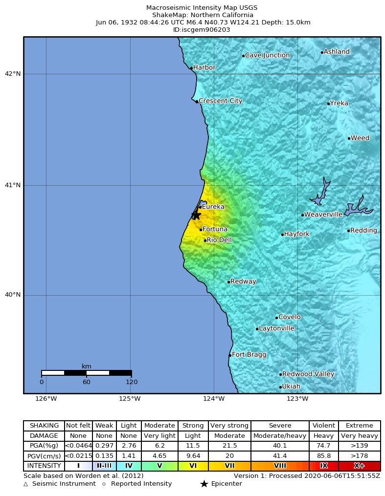
The USGS ShakeMap: shaking estimated from seismic stations and the quake’s size, on the Modified Mercalli intensity scale.
- Strongest estimated
- VII, very strong shaking
- Peak ground acceleration
- 31.3% of gravity
- Peak ground velocity
- 3.3 cm/s
- Map
- Automatic
Did you feel it?
No one has reported feeling this quake to the USGS.
How well it is located
Reviewed by a seismologist.
- Magnitude uncertainty
- ±0.20
- Depth from
- From location
Nearest places
Distance and direction from each place to the epicenter, with its forecast.
Nearby
Within 100 km, magnitude 3.5 and up: 0 in the 60 days after this one and 0 in the 30 days before it.
None recorded.
Earthquakes todayCalifornia earthquakesLive radar here
Sources
From the USGS Earthquake Hazards Program and its partner networks, event iscgem906203 (also filed as ushis899). Read Fri, Oct 2, 2026, 6:37 AM UTC.