Wyoming Plant Hardiness Zones
Wyoming’s towns run from zone 3b to zone 5b: the average coldest winter night is -13.3°F at Cheyenne and -30.5°F at La Barge.
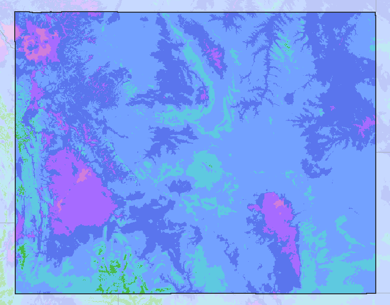
Hardiness zones in Wyoming
In USDA’s colors, neighboring states washed out. Zones follow elevation, coasts and cities down to half a mile. Drawn by WeatherOverTime from the USDA-ARS and Oregon State University PRISM Climate Group 2023 GIS data; this is not the official USDA Plant Hardiness Zone Map.
- 3b
- 4a
- 4b
- 5a
- 5b
- 6a
Towns by zone
Each town’s 1991-2020 average annual extreme minimum at its center, read from the map’s 800 m grid. Warmest zone first.
5b Zone 5b, -15 to -10°F 5 towns
5a Zone 5a, -20 to -15°F 41 towns
- Alpine-18.2°F
- Antelope Valley-Crestview-16.7°F
- Bar Nunn-18.1°F
- Buffalo-17.6°F
- Byron-19.7°F
- Casper-17.4°F
- Clearview Acres-18.4°F
- Cody-16.1°F
- Ethete-19.8°F
- Evanston-17°F
- Evansville-17°F
- Fort Washakie-19°F
- Gillette-16.9°F
- Glenrock-17.9°F
- Green River-18.2°F
- Guernsey-19.4°F
- Hartrandt-17.9°F
- Hoback-19.1°F
- James Town-18.6°F
- Lander-19.4°F
- Lovell-19.8°F
- Lusk-18.3°F
- Lyman-16.7°F
- Mills-16.9°F
- Newcastle-18.1°F
- North Rock Springs-17.7°F
- Pine Bluffs-16.3°F
- Powell-18.4°F
- Purple Sage-17.9°F
- Rawlins-18.7°F
- Reliance-18.2°F
- Rock Springs-17.3°F
- Sleepy Hollow-17.3°F
- Star Valley Ranch-19.8°F
- Story-17.1°F
- Sundance-19°F
- Thermopolis-19.3°F
- Torrington-18.2°F
- Vista West-18.1°F
- Wheatland-18.4°F
- Wright-19.4°F
4b Zone 4b, -25 to -20°F 28 towns
- Afton-21.4°F
- Arapahoe-20.8°F
- Basin-20.9°F
- Bear River-20.1°F
- Cowley-20.1°F
- Dayton-20.4°F
- Diamondville-22.1°F
- Douglas-20.9°F
- Dubois-20.7°F
- Greybull-22.7°F
- Hanna-20.6°F
- Jackson-22.8°F
- Kemmerer-21.9°F
- Lucerne-22.8°F
- Moorcroft-22.6°F
- Moose Wilson Road-23.1°F
- Pine Haven-23.4°F
- Rafter J Ranch-21.7°F
- Ranchester-20.9°F
- Riverton-21.6°F
- Saratoga-21.1°F
- Sheridan-22.2°F
- Shoshoni-23.8°F
- South Park-21.6°F
- Upton-21.1°F
- Washakie Ten-23.1°F
- Wilson-23°F
- Worland-22.3°F
4a Zone 4a, -30 to -25°F 5 towns
3b Zone 3b, -35 to -30°F 1 towns
Counties
At the county’s center; a county with hills or a coast spans several zones.
| County | Zone at the center | Average coldest night |
|---|---|---|
| Albany County | 4a | -25.2°F |
| Big Horn County | 4b | -21.4°F |
| Campbell County | 5a | -16.7°F |
| Carbon County | 5a | -18.3°F |
| Converse County | 5a | -19.1°F |
| Crook County | 5a | -16.6°F |
| Fremont County | 5a | -17.8°F |
| Goshen County | 5a | -19.6°F |
| Hot Springs County | 4b | -20.4°F |
| Johnson County | 5a | -19.9°F |
| Laramie County | 5b | -14.1°F |
| Lincoln County | 5b | -12.3°F |
| Natrona County | 5a | -17°F |
| Niobrara County | 5a | -18.6°F |
| Park County | 5a | -18.2°F |
| Platte County | 5a | -19.4°F |
| Sheridan County | 5a | -20°F |
| Sublette County | 4b | -22.1°F |
| Sweetwater County | 5b | -14.8°F |
| Teton County | 4b | -20.3°F |
| Uinta County | 5b | -13.1°F |
| Washakie County | 4b | -22.8°F |
| Weston County | 4b | -21.9°F |
The zones
A plant hardiness zone is set by the average of each winter’s single coldest temperature, 1991 to 2020: zones are 10°F apart and each half zone, a and b, 5°F. It says how cold a winter night usually gets, not the coldest it has ever been, and nothing about summer heat, rain or soil. Plant labels give the coldest zone a perennial survives in.
| Zone | Average coldest night | In Celsius |
|---|---|---|
| 3b | -35 to -30°F | -37.2 to -34.4°C |
| 4a | -30 to -25°F | -34.4 to -31.7°C |
| 4b | -25 to -20°F | -31.7 to -28.9°C |
| 5a | -20 to -15°F | -28.9 to -26.1°C |
| 5b | -15 to -10°F | -26.1 to -23.3°C |
Sources
Hardiness zones: USDA Plant Hardiness Zone Map, 2023, Agricultural Research Service, U.S. Department of Agriculture, from the GIS data of the PRISM Climate Group, Oregon State University, which may be freely reproduced and redistributed. Drawn by WeatherOverTime from the USDA-ARS and Oregon State University PRISM Climate Group 2023 GIS data; this is not the official USDA Plant Hardiness Zone Map.